
- Key Takeaways
- What Are Drone Flight Hazards?
- Obstacles Below 200 Feet AGL
- The Wire Environment
- Power Lines and Transmission Lines
- Guy Wires and Antenna Support Cables
- Antenna Towers and Communication Structures
- Thermal Plumes: Smoke Stacks and Cooling Towers
- How to Avoid Thermal Plumes
- Reading Obstacles on Sectional Charts
- How to Mitigate Flight Hazards Before You Fly
- Frequently Asked Questions
- What Are the Biggest Physical Hazards When Flying a Drone?
- How Far Should I Fly From a Guyed Tower?
- Can Thermal Plumes Damage a Drone?
- How Do I Find Obstacles in My Planned Flight Area?
- Conclusion
The most common drone flight hazards are power lines, guy wires, communication and broadcast towers, and thermal plumes.
Many are hard to see or unmarked, and the FAA lists them in the Aeronautical Information Manual, Section 7-6.
The best defense is to scout obstacles before you fly and keep a wide margin around anything tall or wired.
Sure, your drone has obstacle avoidance, GPS, and a return-to-home function. But don’t get too comfortable depending on technology alone.
Not every flight hazard is obvious. Razor-thin guy wires can blend into the sky, and thermal plumes often hide in plain sight. These hazards are nearly impossible to see until it’s too late.
Let’s take a closer look at the physical flight hazards lurking in our airspace and how to avoid obstacles when flying a drone.
Key Takeaways
- Power lines and guy wires can be very hard to see.
- Cell towers are often 50–200 feet AGL and may be unmarked.
- Broadcast towers can exceed 2,000 feet and have wide guy wires.
- Thermal plumes can cause turbulence and wind shear above towers.
What Are Drone Flight Hazards?
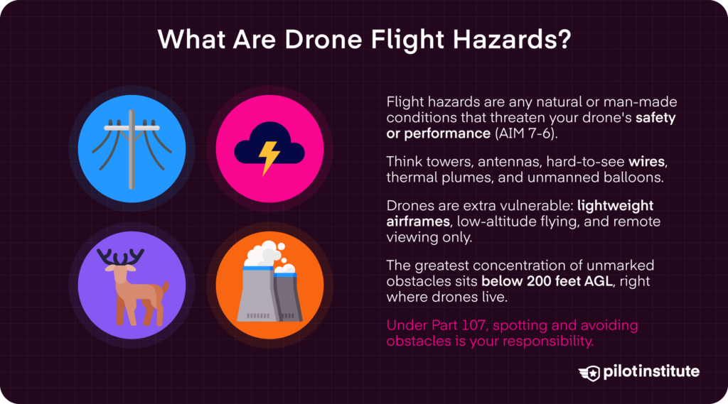
Drone flight hazards are any natural or man-made conditions that interfere with a drone’s safety or impact its performance. The FAA highlights several of these risks in the Aeronautical Information Manual (AIM), Section 7-6: Potential Flight Hazards.
Obstructions such as towers, antennas, difficult-to-see wires, thermal plumes, and unmanned balloons pose serious crash risks.
Such hazards are especially dangerous to drones because of the way they fly. Pilots fly low-altitude operations using drones with lightweight airframes. Unlike manned aircraft, drone pilots also rely entirely on remote viewing and onboard sensors.
Obstacles Below 200 Feet AGL
Drones operate below 400 feet above ground level (AGL). This means they share airspace with obstacles and hazards that are less of a concern for higher-flying manned aircraft.
In fact, the greatest concentration of unmarked obstacles exists below 200 feet AGL. At these low altitudes, power lines and guy wires can be difficult to identify until you’re already dangerously close. Overgrown trees and temporary construction cranes may unexpectedly crowd your flight path.
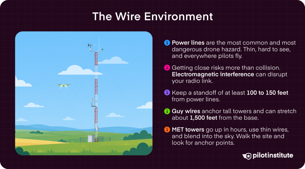
Meteorological towers (METs) are portable and often erected quickly. They are supported by thin guy wires and often built from galvanized material that blends into the sky.
Many hazards are uncharted. Under Part 107, the remote pilot in command is ultimately responsible for identifying and avoiding obstacles before and during flight operations.
The Wire Environment
Power Lines and Transmission Lines
Power and transmission lines are the most common (and most dangerous) flight hazards for drone operators.
The wires are extremely thin, making them difficult to see against vegetation or in changing light conditions. They obviously pose serious collision risks, but getting too close can also result in electromagnetic interference that can disrupt your drone’s radio signals.
These lines also frequently run through areas where drone pilots operate, including rural landscapes, construction zones, and utility corridors.
It’s critical to conduct thorough preflight surveys, visually noting the presence of any powerlines before taking off.
In the air, continuously scan for wires that may pop up unexpectedly. Maintain a conservative standoff distance of at least 100 to 150 feet.
These days, drones are often used in powerline inspections to improve efficiency and reduce risk to human crews. In such close quarters, careful preflight planning is essential.
Review any recent aerial imagery of the area and establish a clear inspection corridor before taking off. Once in the air, fly at a reduced speed and focus on smooth inputs. Maintain a continuous visual line of sight (VLOS) to avoid unexpected wires or obstacles along your flight path.
Guy Wires and Antenna Support Cables
Many drone collisions involve support cables, rather than actual towers themselves.
Guy wires are thin, steel cables that anchor tall radio, TV, or cell towers. They can extend up to 1,500 feet horizontally from the base of the structure.
These supporting wires often easily blend into the terrain or can be hard to see in changing lighting conditions.
In Advisory Circular (AC) 70/7460-1M, the FAA recommends maintaining a horizontal distance of at least 2,000 feet from guyed towers.
Before taking off, identify all nearby towers on satellite maps and sectional charts. Then extend your mental map beyond the tower itself to account for any unmarked guy wires.
Physically walk the site to look for anchor points, disturbed ground, or symmetry patterns that would suggest the presence of guy wires.
In flight, avoid orbiting close to towers at low altitude, as this is the angle where guy wires can be the hardest to spot. Instead, keep a wider standoff distance and approach from above.
Antenna Towers and Communication Structures
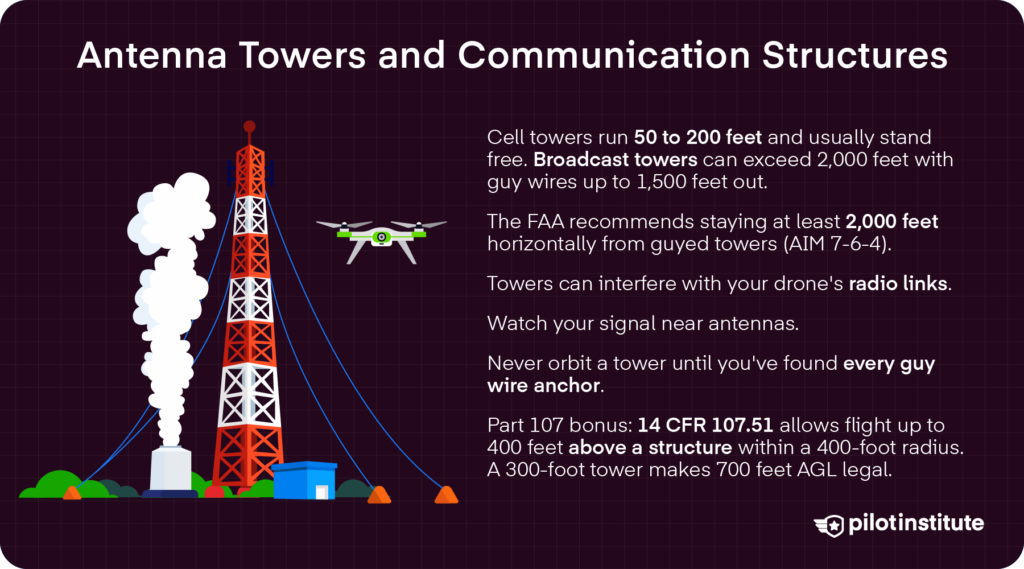
Cell towers are fixed masts that send and receive the signals we use on our mobile devices. According to service provider T-Mobile, cell towers typically range from 50 to 200 feet tall. Free-standing towers, like most cell antennas, do not have guy wires.
TV and radio broadcast towers can be a lot taller. Some exceed 1,000 feet AGL and are often supported by guy wires that extend hundreds of feet from the base.
Towers themselves are often not a single vertical structure, either. Many have various antennas, lighting fixtures, and other auxiliary components that extend outward from the main mast.
Cellular and broadcast towers can also impact frequency environments, potentially interfering with your drone’s essential communication links.
Still, drones are often used in inspecting cellular or broadcast towers. This requires pilots to operate close to structures intentionally.
In addition to reviewing recent imagery of the structures, pilots should conduct ground reconnaissance to identify any guy wire anchor points.
Always keep a generous safe operating buffer around structures and avoid orbiting towers unless you’ve identified the location of all supporting wires.
Luckily, Part 107 offers some flexibility in flying near tall structures. In fact, 14 CFR §107.51 allows flight up to 400 feet above a structure when operating within a 400-foot horizontal radius.
So, if you’re within 400 feet of a 300-foot cell tower, flying under Part 107 allows flight up to 700 feet AGL.
Thermal Plumes: Smoke Stacks and Cooling Towers
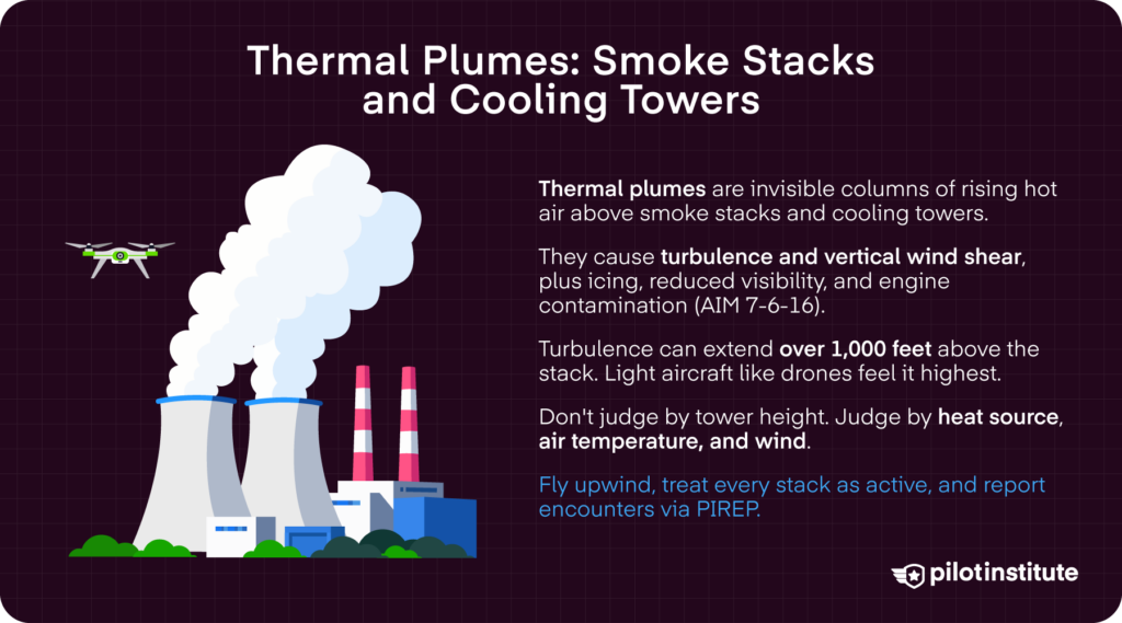
Thermal plumes are invisible columns of rising warm air. As the warm air rises, it forms localized updrafts that can affect a drone’s stability and flight performance.
Such plumes are often associated with visible or invisible emissions from power plants, industrial facilities, or other systems that release large amounts of vertically directed, unstable gases.
According to AIM 7-6-16, the high air temperatures in thermal plumes can result in turbulence and vertical wind shear, or the sudden shift in wind speed or direction as altitude increases.
Plumes from industrial stacks and cooling towers can also cause reduced visibility, rapid oxygen depletion, exposure to gaseous oxides, and icing. They can even result in engine particulate contamination, which can reduce efficiency and even lead to failure.
These effects are often more significant when the air around the plume is cold and stable.
Turbulence from thermal plumes can extend over 1,000 feet above the top of smoke stacks and cooling towers. Smaller aircraft, like drones, can feel the effects at higher altitudes than heavier aircraft.
Don’t rely on the size of the tower to determine how high you think the plume goes. Rather, consider the heat source, the ambient air temperature, and wind speed.
How to Avoid Thermal Plumes
Try to fly upwind of any visible smokestacks and cooling towers. Treat any stacks with caution, even if you can’t see visible plumes. Invisible plumes can be just as dangerous as the ones we can see.
Always check the Chart Supplement for any notes about structures in the area that may emit exhaust plumes.
When you do have to fly around smoke stacks or cooling towers, choose a day with a bit of a crosswind, as this helps dissipate the negative effects.
AIM 7-6-16 asks pilots to report hazardous plume encounters, including time, location, and intensity. As a drone pilot, you can contact the nearest FAA facility and file a report through the Aviation Weather Service’s PIREP submission.
Reading Obstacles on Sectional Charts
The FAA publishes VFR sectional charts to inform pilots of airspace conditions, terrain, and potential flight obstacles.
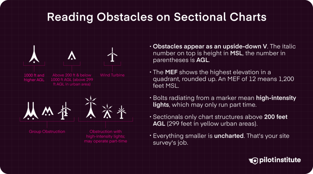
The Maximum Elevation Figure (MEF) shows the highest known elevation within the quadrant of a sectional chart. That includes both natural terrain and man-made obstacles, including towers.
The MEF is rounded up to the next highest 100-foot increment. The last two digits of the MEF are omitted. So, an MEF of 12 represents a maximum elevation of 1,200 feet MSL in that quadrant.
When reading sectional chart obstacles, structures appear as obstacle markers that look like a small triangle, or an upside-down letter “V.” One marker indicates a single tower less than 1,000 feet AGL.
A group of them indicates a cluster of structures, such as towers or a wind farm with several windmills. In dense urban areas, only the highest obstacle in a group has its height listed.
These markers have an italicized number next to the top of the symbol, which lists the height in Mean Sea Level (MSL). At the bottom of the structure marker is the AGL in parentheses.
FAA sectionals typically only mark structures higher than 200 feet AGL. In yellow-tinted urban areas, that increases to structures more than 299 feet AGL.
Given that most flights are under 400 feet AGL, that means drone pilots must be vigilant in identifying smaller towers during preflight planning and in-flight.
Markers with bolts radiating from the top indicate the presence of high-intensity lights, although these lights may only operate on a part-time basis.
It’s also important to note that towers and other structures still under construction may appear on charts before completion.
Want a more detailed guide on reading sectionals? Check out our easy-to-read guide to reading sectional charts.
Remember, many smaller obstacles under 200 feet are not depicted on sectional charts.
How to Mitigate Flight Hazards Before You Fly
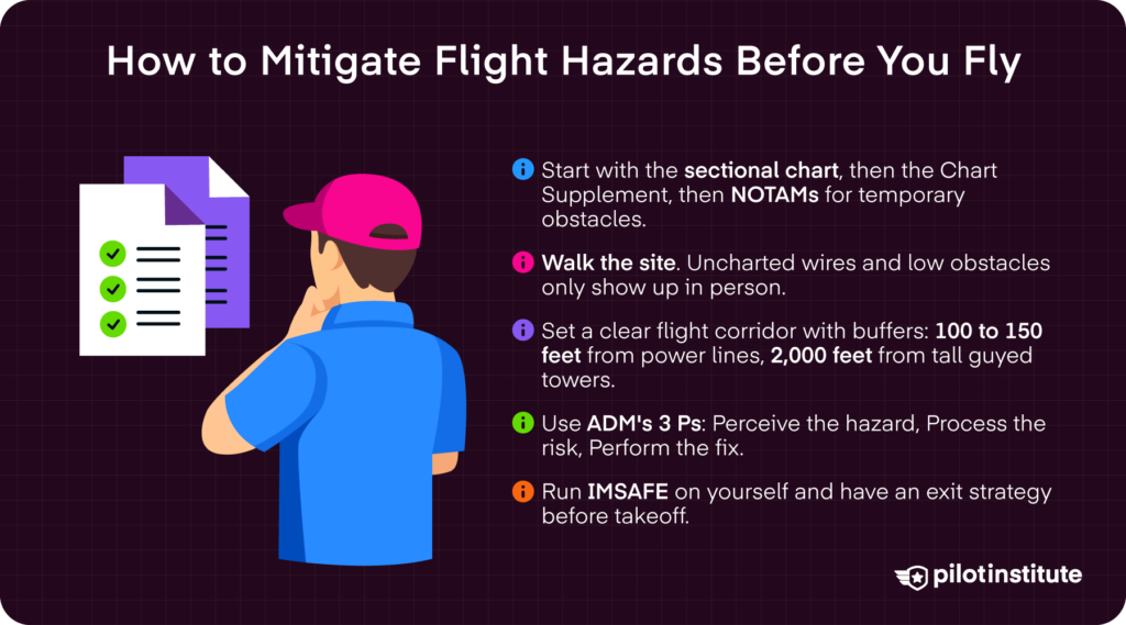
First, read the FAA’s VFR sectional charts to identify charted obstacles.
Next, check the Chart Supplement for additional airport information, special notices, and other navigational aids.
Search for any temporary flight obstacles detailed in Notice to Airmen (NOTAMs).
When on site, observe all the details around you. Conducting a thorough site survey helps you identify uncharted hazards, like powerlines, guy wires, and other low-altitude obstructions.
Give yourself a safety buffer and a designated flight corridor clear of obstacles. Avoid orbiting around the base of structures. Maintain slow, deliberate movements while keeping your eyes peeled for unexpected hazards. Stay 100 to 150 feet from powerlines and 2,000 feet horizontally away from tall towers.
Most importantly, have a contingency plan. After conducting your site survey, have an exit strategy in mind in case things go awry.
Remember, risk management is a key Part 107 test topic. It’s also a real-world obligation. Make sure you brush up on risk management principles such as hazard identification, operational decision-making, and safety maintenance procedures.
There are some helpful models to strengthen your risk management protocol, especially when operating under Part 107.
Aeronautical Decision-Making (ADM) provides a way to evaluate conditions and make safe operational choices. The model asks you to implement the 3 Ps in every flight: Perceive, Process, and Perform. Observe your surroundings to perceive hazards. Evaluate the potential impact of those hazards. Then, act to resolve the risks.
The IMSAFE Checklist helps you assess your personal readiness. Evaluate Illness, Medication, Stress, Alcohol, Fatigue, and Emotional factors before every flight.
Frequently Asked Questions
What Are the Biggest Physical Hazards When Flying a Drone?
The biggest physical hazards for drones are often found at 200 feet AGL and under. These include natural terrain features as well as man-made obstacles such as power lines, transmission wires, cellular and broadcast towers, and thermal plumes.
How Far Should I Fly From a Guyed Tower?
The FAA recommends flying at least 2,000 feet of horizontal distance from a guyed tower. This is a recommendation, not a regulation. But remember, guy wires can extend up to 1,500 feet from the base of towers, so it is best practice to follow such sage advice.
Can Thermal Plumes Damage a Drone?
Yes, thermal plumes can cause turbulence, vertical wind shear, and engine particulate contamination that can impact your drone’s performance and safety. These effects can extend 1,000 feet or more above the stack emitting the plume. Lighter aircraft, like drones, are also more susceptible.
How Do I Find Obstacles in My Planned Flight Area?
Start by reading VFR sectional charts and the Chart Supplement to identify charted obstacles, including towers. Next, review NOTAMs for temporary hazards, such as cranes or airspace use changes. Finally, conduct a thorough on-site survey, watching out for power lines, guy wire anchors, and smaller structures that may not be charted.
Conclusion
Technology can help you avoid hazards, but it can’t spot every hidden risk. Take a few minutes before takeoff to identify any obstacles lurking in your area to keep your drone (and mission) safe.
The best defense comes from awareness. Read the FAA’s VFR sectional charts and search for any NOTAMs in your area. Focus on pre-flight planning, including a thorough site survey to mark potential obstacles, like power lines or guy wires.
Train yourself to spot risks before takeoff to avoid the hazards that technology can’t.