-
Key Takeaways
-
What Is Controlled Airspace?
- Classes of Airspace - Concerning UAS
- Uncontrolled Airspace - In Relation to UAS
-
Why Is Authorization Required?
- Do You Need ATC Permission?
-
The Traditional Airspace Authorization Process
- Previous Requirements for Airspace Authorization
- Limitations of the Manual Process
-
Introduction of LAANC and Its Impact
- What Is LAANC?
- How LAANC Works
- Benefits of LAANC
- LAANC Coverage
-
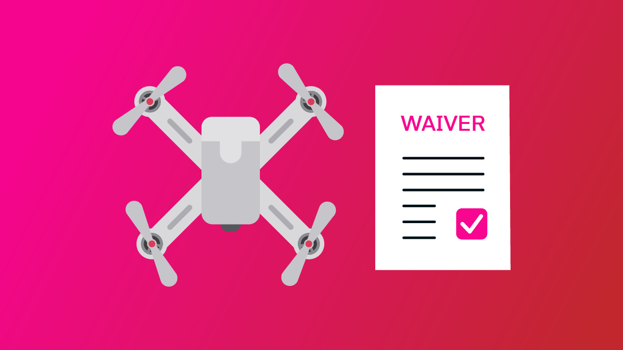
When Is a Waiver Still Necessary?
- Limitations of LAANC
- Special Operations Requiring Waiver
- Drone News Update
- Obtaining a Waiver
-
Recent Regulatory Changes Affecting Waivers
- Updates to Night Operations Regulations
- Operations Over People and Moving Vehicles
- Implications for Drone Pilots
-
Steps to Fly a Drone in Controlled Airspace Without a Waiver
- Utilizing LAANC
- Areas Without LAANC Coverage
- Compliance with Authorization Conditions
-
Best Practices for Drone Operations Compliance
- Staying Informed on Regulations
- Pre-Flight Planning Tools
- Training and Certification
-
Conclusion
FAA waivers have long been a hurdle for pilots flying in controlled airspace. Fortunately, the process is not as much of a headache as it used to be.
As FAA regulations evolve and systems like LAANC become more accessible, drone pilots need to stay informed.
With all these changes, do you still need a waiver for your operation? Let’s take a look at the facts.
Key Takeaways
- Learn the ins and outs of the different types of airspace with this detailed guide.
- Understand how to apply for LAANCs using FAA-approved UAS Service Suppliers (USS), like Aloft.
- Grasp the differences between an LAANC and an FAA Waiver so that you can fly in full compliance.
- Know what special scenarios still require a waiver, such as flying BVLOS operations, flights above people, or flights that exceed the standard 400 feet AGL.
- Discover how to apply for a waiver with our helpful tips.
What Is Controlled Airspace?
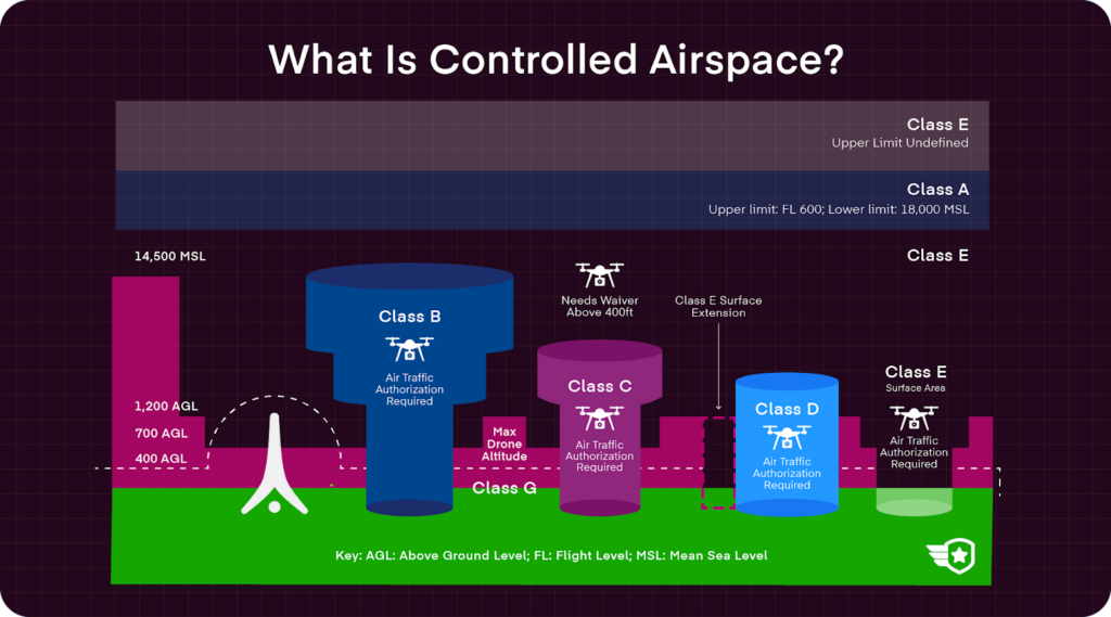
The FAA defines controlled airspace as “a generic term that covers the different classifications of airspace (Class A, Class B, Class C, Class D, and Class E airspace) and defined dimensions within which air traffic control service is provided to IFR and VFR flights.”
What does that mean? Controlled airspace is where air traffic control (ATC) services are provided to aircraft to safely and efficiently guide flight operations. Controlled airspace tends to be located near sensitive or busy areas, such as airports.
Within controlled airspace, there are specific rules and communication requirements pilots must abide by, depending on what class of airspace they are operating in.
Classes of Airspace – Concerning UAS
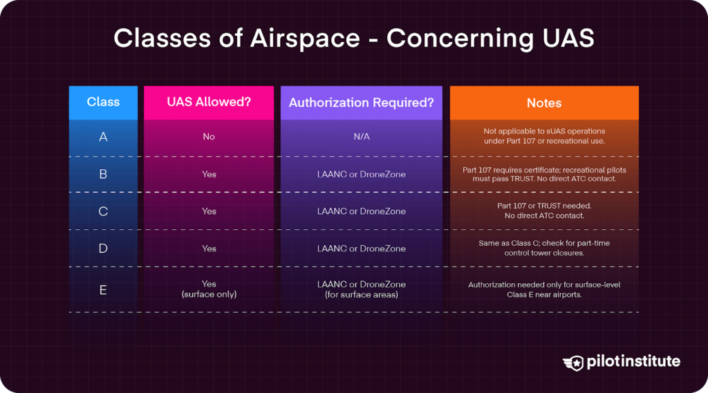
Class A
Altitude Range:
- From 18,000 feet MSL up to and including FL600 (60,000 feet).
Key Features:
- IFR flights only—requires instrument rating.
- Requires: Two-way radio, Mode C transponder, and ADS-B Out.
- Aircraft must operate under ATC clearance.
- Not commonly shown on sectional charts.
- Not accessible to drones.
Class B
Altitude Range:
- Surface to 10,000 feet MSL.
- Surrounds major airports, often shaped like an inverted wedding cake.
Requirements for All Aircraft:
- Two-way radio communication with ATC.
- Mode C transponder and ADS-B Out within 30 NM.
- Depicted on sectional charts with solid blue lines.
UAS Rules (Part 107):
- Must hold a Remote Pilot Certificate and obtain ATC authorization (via LAANC or DroneZone).
- Max speed: 100 mph (87 knots).
Manned Pilots:
- Must hold at least a private pilot certificate (with exceptions for certain endorsements).
Class C
Altitude Range:
- Surface to 4,000 feet above airport elevation (charted in MSL).
Typical Structure:
- Two-tiered surface and shelf area:
- Inner core: 5 NM radius.
- Shelf area: 10 NM radius, from 1,200 ft AGL to 4,000 ft AGL.
- Found around busy regional airports.
Requirements:
- Two-way ATC communication required before entry.
- VFR: Minimum 3 miles visibility.
- Depicted on sectional charts with solid magenta lines.
UAS Rules (Part 107):
- Remote Pilot Certificate and ATC authorization required.
- Max speed: 100 mph (87 knots).
Class D
Altitude & Shape:
- Surface to 2,500 feet AGL (charted in MSL).
- Shaped like a cylinder with a 4–5 NM radius.
- Depicted with dashed blue lines on sectional charts.
- Ceiling is labeled in brackets within the airspace.
Key Features:
- Surrounds smaller airports with an operational control tower.
- Part-time use: May revert to Class E or G when tower closes (marked with a * on sectional charts).
- Requires two-way radio communication before and during entry.
Weather & VFR Rules:
- Minimum visibility: 3 statute miles.
- Cloud clearance: 500 ft below, 1,000 ft above, 2,000 ft horizontal.
UAS Operations (Part 107):
- ATC authorization required.
- Pilot must hold a Remote Pilot Certificate.
- Max speed: 100 mph (87 knots).
Class E
Altitude & Coverage:
- Begins at 700 or 1,200 feet AGL, extending up to 18,000 feet MSL.
- Can start at surface level near some airports.
- Controlled airspace not classified as A, B, C, or D.
- Depicted with faded magenta lines on sectional charts.
ATC & Communication:
- No ATC clearance required for VFR.
- No radio communication required.
Weather & VFR Rules:
- Below 10,000 ft MSL:
- 3 miles visibility, 500 ft below, 1,000 ft above, 2,000 ft horizontal from clouds.
- Above 10,000 ft MSL:
- 5 miles visibility, 1,000 ft above/below, 1 mile horizontal from clouds.
UAS Operations (Part 107):
- ATC authorization is required if operating near an airport.
Uncontrolled Airspace – In Relation to UAS
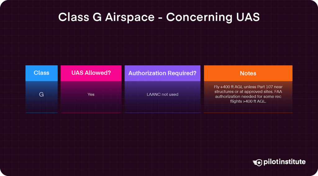
Class G
Class G airspace typically extends from the surface up to the base of Class E airspace. It is not depicted on sectional charts and does not require any entry clearance or radio communication with air traffic control.
For operations at or below 10,000 feet MSL:
- Daytime: 1,200 feet AGL or less: Requires 1 statute mile visibility and pilots must keep the aircraft clear of clouds.
- Nighttime: 1,200 feet AGL or less: Requires 3 statute miles visibility and cloud clearance of 500 feet below, 1,000 feet above, and 2,000 feet horizontally (note: Part 107 sUAS operations always require 3 statute miles visibility from the control station per § 107.51(c)).
- Daytime: more than 1,200 feet AGL but less than 10,000 feet MSL: Requires 1 statute mile visibility and cloud clearance of 500 feet below, 1,000 feet above, and 2,000 feet horizontally.
- Nighttime: more than 1,200 feet AGL but less than 10,000 feet MSL: Requires 3 statute miles visibility and cloud clearance of 500 feet below, 1,000 feet above, and 2,000 feet horizontally.
For operations in Class G airspace more than 1,200 feet AGL and at or above 10,000 feet MSL: Requires 5 statute miles visibility and pilots must maintain cloud clearance of 1,000 feet below, 1,000 feet above, and 1 statute mile horizontally from clouds.
Recreational aircraft may operate in Class G airspace where the aircraft is flown from the surface to not more than 400 feet AGL, and the operator must comply with all airspace restrictions and prohibitions. (AIM, Chapter 11, Section 2)
Most drone operations occur below 400 feet AGL, intersecting with controlled airspace near airports.
Why Is Authorization Required?
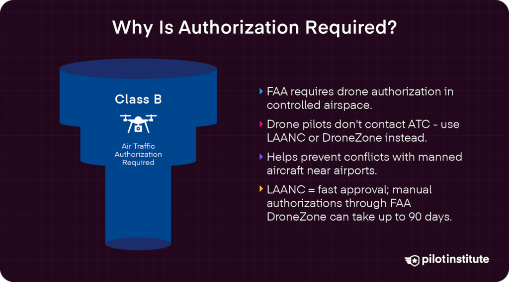
The Federal Aviation Administration (FAA) mandates authorization to ensure coordinated airspace use. Unauthorized flights can result in legal penalties and endanger others.
Air Traffic Control (ATC) is the main manager of aircraft movement within controlled airspace. Seeking authorization from ATC is required in certain airspace, such as Class B and C. It allows towers to be aware of drone movements and manage airspace safely and effectively.
Authorization in busy airspace prevents conflicts between drones and manned aircraft, especially during vulnerable takeoff and landing phases. Protecting airspace integrity also ensures greater public safety, as sensitive areas are more controlled.
Do You Need ATC Permission?
For all aircraft, ATC permission is required in Class B and C airspace.
Drone pilots have additional requirements from the FAA that require authorization for all drone operations in controlled airspace. This applies to both Part 107 and recreational pilots.
Typically, this does not mean that pilots must contact ATC specifically. In fact, the FAA has simplified the process of obtaining authorization with the Low Altitude Authorization and Notification Capability (LAANC).
The Traditional Airspace Authorization Process
Previous Requirements for Airspace Authorization
In the past, pilots had to manually submit authorization requests to the FAA via the DroneZone website, where pilots register their UAS. Requests required detailed information about the operations and sometimes took up to 90 days to be approved.
This created significant challenges for pilots who had limited timeframes for their operations. Lengthy processing times affected mission planning and business operations.
Limitations of the Manual Process
One of the biggest issues was that this process was an administrative burden. Extensive paperwork and documentation were required, where a high volume of requests led to backlogs and delays.
Drone operations were also impacted. Pilots’ opportunities and operations were limited. This ultimately discouraged some pilots from operating in controlled airspace altogether due to procedural complexities.
Introduction of LAANC and Its Impact
What Is LAANC?
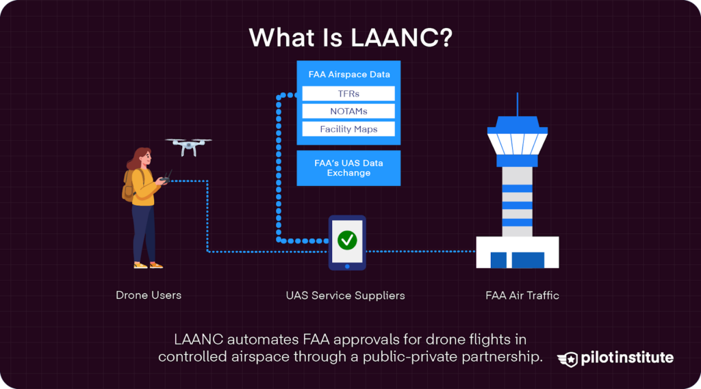
The Low Altitude Authorization and Notification Capability (LAANC) is a collaboration between the FAA and private industry that is designed to automate the approval process for drone operations in controlled airspace.
According to the FAA, “LAANC is the Low Altitude Authorization and Notification Capability, a collaboration between FAA and industry. It automates the application and approval process for airspace authorizations.” (AIM, Chapter 11, Section 8).
Sharing data facilitates faster authorizations for drone pilots and enhances airspace safety by providing real-time awareness to both pilots and ATC.
How LAANC Works
Today, pilots can seek authorization on the go, getting approval in mere minutes, in most cases. Mobile apps like Aloft’s Air Control or Wing’s Open Sky simplify pre-flight planning by combining airspace maps, authorization, and compliance tools.
Pilots simply submit a LAANC flight request through a variety of FAA-approved UAS Service Suppliers (USS). These include:
- Aloft
- AirMatrix
- Airspace Link
- AstraUTM
- AutoPylot
- Avision
- eTT Aviation
- Flightloop
- FlightReady
- FlyFreely
- UASidekick
- Wing
After inputting details such as location, altitude, and time of operation, LAANC processes the request instantly using real-time FAA data.
Benefits of LAANC
Without all the red tape, applying for LAANC is a lot easier–and faster. Most apps provide near-instant approval for spontaneous and flexible drone operations.
LAANC tools are available for both Part 107 and recreational pilots. Now, every pilot has access to accurate airspace information and enhanced flight data thanks to easy coordination with ATC.
Such ease of use and accessibility encourage us all to stay compliant.
LAANC Coverage
Currently, LAANC is available at 732 airports and air traffic facilities across the United States, covering approximately 81% of controlled airspace.
While the list keeps growing each year, there are still some controlled airspace areas not yet integrated with LAANC. Pilots should always revert to the manual authorization in regions not yet covered.
When Is a Waiver Still Necessary?
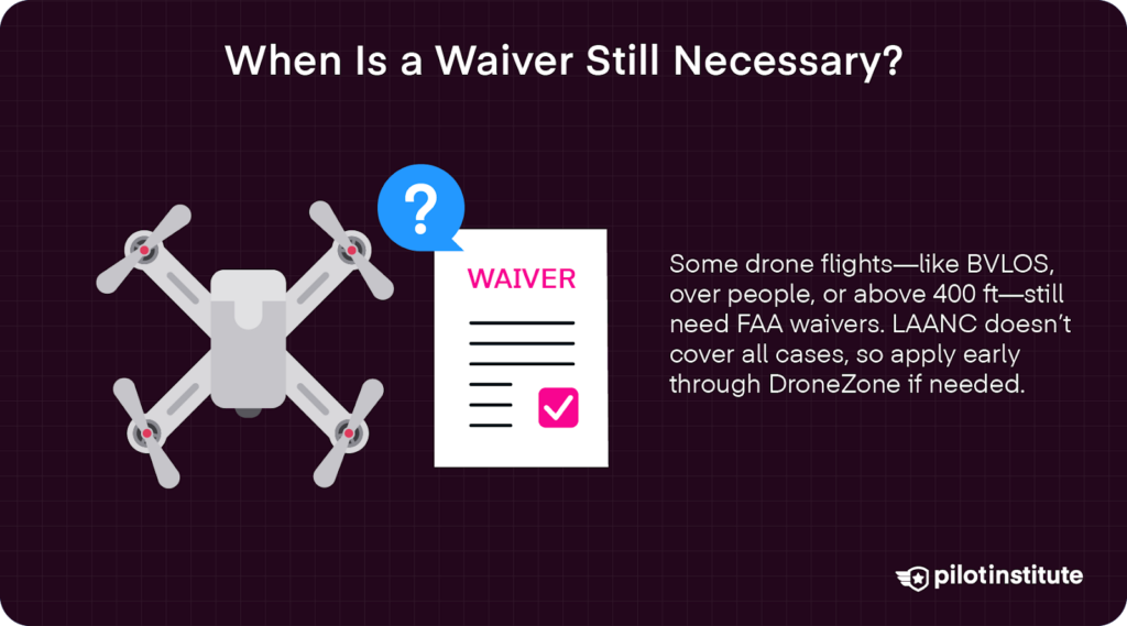
There are several instances where a waiver is still necessary. Certain airports and controlled airspace are not covered by LAANC, including some Class D and Class E locations.
Limitations of LAANC
LAANC provides predetermined maximum allowable altitudes in specific grid areas. For more complex operations that need to fly above 400 feet, Part 107 pilots can seek a “further coordination request,” up to 90 days in advance of a flight.
Additionally, LAANC is designed for standard visual line of sight (VLOS) operations under Part 107 rules, including night operations provided the pilot meets all requirements under § 107.29. Specialized operations, such as beyond visual line of sight (BVLOS), are not authorized through LAANC and require a separate waiver.
Special Operations Requiring Waiver
Beyond Visual Line of Sight (BVLOS)
Flying the drone beyond the pilot’s direct line of sight requires a waiver due to increased safety risks. According to the FAA, “Part 107 includes the opportunity for individuals to request waivers for certain provisions of the rules, for example, Beyond Visual Line-Of-Sight (BVLOS)” (AIM, Chapter 11, Section 2).
Waivers are thus often required for operations including long-distance mapping, infrastructure inspection, or delivery operations.
Operations Over People
Flying over unprotected individuals not directly participating in the operation often requires a waiver granted by the FAA.
While UAS categories 1-4 have been granted greater permissions under recent regulations, it is still important to check if your operation would require a waiver to fly over people, especially those not involved in the operation.
Operations Over Moving Vehicles
Similar to flying over people, there is greater flexibility for most UAS classes thanks to recent updates to FAA rules that do not require a waiver for flights over closed or restricted sites where notice is given beforehand.
However, flying over moving traffic has specific restrictions. A waiver may be needed if the operation involves flying in an unrestricted site.
Flying in Restricted or Prohibited Areas
“Restricted” areas, such as military installations, wilderness areas, national parks, sports stadiums, or other sensitive areas, are still largely restricted under current FAA rules. While difficult to access, special permission and/or waivers are required to operate in these zones.
Drone Operations Above Maximum Allowable Altitudes
Flying above 400 feet AGL (when not within a 400-foot radius of a structure and above its uppermost limit) requires a waiver of 14 CFR § 107.51(b). For operations within controlled airspace that exceed LAANC-approved altitudes (UASFM ceilings) but are still within Part 107’s general altitude limits.
Part 107 pilots can seek a higher authorization, potentially through a LAANC “further coordination request,” which can be submitted up to 90 days in advance, or via FAA DroneZone.
Obtaining a Waiver
This application process formerly used the FAA’s DroneZone website, but now you can apply for a waiver using the Aviation Safety Hub. Pilots will need to create an account and log in. They can then submit a detailed waiver application, outlining the proposed operation.
Tips for a Successful Waiver Application
- Be Thorough and Clear: Provide detailed information to demonstrate understanding and preparedness.
- Demonstrate Safety Measures: Highlight how risks will be managed and minimized.
- Plan Ahead: Submit applications well in advance, as processing can take 90 days or more.
- Follow FAA Guidance: Utilize FAA resources and guidelines to ensure compliance with application requirements.
Recent Regulatory Changes Affecting Waivers
Updates to Night Operations Regulations
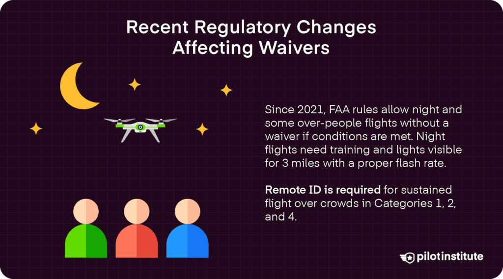
In January 2021, the FAA introduced Amendments to Part 107 that reduced the need for waivers.
Pilots can now conduct night flights without a waiver, as long as the pilot has completed training on operating at night. This training requires pilots to demonstrate their knowledge of night physiology and visual illusions. The FAA offers recurrent training courses online, so pilots can keep up-to-date.
Additionally, the UAS has to have anti-collision lighting that is visible for at least 3 statute miles and has a flash rate sufficient to avoid collisions.
Operations Over People and Moving Vehicles
New operational categories were introduced for flying over people and moving vehicles in 2021, meaning some operations that previously required waivers may not need the extra effort anymore.
Category 1 drones weigh 0.55 lbs (250 grams) or less and can operate over people without a waiver. These drones are also required to “contain no exposed rotating parts that would cause lacerations,” according to the FAA. Any flights over open-air assemblies must be done with a UAS that is compliant with Remote ID.
Category 2 and 3 UAS approval is based on certain performance-based eligibility requirements. These drones may weigh more than 0.55 lb and require Remote ID.
Additionally, under 14 CFR § 107.120(b), Category 3 UAS may not be flown over open-air assemblies of human beings. For operations over people not in an open-air assembly, Category 3 UAS must not conduct sustained flight over any human being unless that person is directly participating in the operation or is under a covered structure or inside a stationary vehicle providing reasonable protection.
Category 4 drones may fly over people or moving vehicles only if they have an airworthiness certificate under Part 21. Sustained flight over open-air assemblies requires the UAS to have Remote ID. Additional requirements may apply, so it is important for pilots with Category 4 drones to check with the FAA.
In terms of flights over moving vehicles, Category 1, 2, and 3 drones are allowed to fly over moving vehicles if:
- (1) the operation is within or over a closed- or restricted-access site, and all human beings located inside a moving vehicle within the site are on notice that a small unmanned aircraft may fly over them (in which case sustained flight is permissible);
- OR (2) the small unmanned aircraft does not maintain sustained flight over any moving vehicles (if not operating under the closed-site-with-notice provision).
Implications for Drone Pilots
The reduced requirements make it easier for pilots to conduct night flights and operations over people under specific conditions.
As regulations continue to evolve, however, pilots must keep up-to-date to best take advantage of them.
With new opportunities for expanded operations, pilots can explore new business opportunities with fewer regulatory hurdles.
Despite eased restrictions, safety remains paramount. As such, compliance with all operational requirements is essential.
Steps to Fly a Drone in Controlled Airspace Without a Waiver
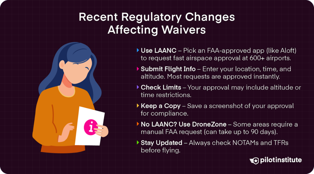
Utilizing LAANC
First, pilots choose an FAA-approved LAANC service provider. According to the FAA, “using applications developed by an FAA-approved UAS service supplier (USS), you can apply for an airspace authorization at over 600 airports.” (AIM, Chapter 11, Section 8).
One of the most popular today is Aloft, which offers an easy-to-use mobile application that offers rapid application turnaround times.
Next, prepare your flight details. After reviewing airspace maps and any altitude restrictions, determine the exact location, date, time, and altitude of your planned flight. Submit these details to the LAANC system.
Receiving authorization is faster and easier than ever before. Most LAANC applications are processed instantly, receiving approval or denial based on current airspace and traffic data.
Once an application is accepted, note any specific limitations or further requirements. Often, a LAANC approval will come with a maximum flight altitude below the typical 400 feet AGL or other requirements based on the unique circumstances of the location and flight traffic.
Keep a copy of the authorization accessible during your flight, either digital or printed. Often, a simple screenshot of the approval will suffice. Record-keeping aids in compliance and serves as proof if questioned.
Areas Without LAANC Coverage
For areas that are not covered by the LAANC system, pilots will have to revert to requesting airspace authorization through the FAA’s DroneZone website.
Log in to your FAA DroneZone account and navigate to the Airspace Authorization section. Provide detailed flight information, operational purpose, equipment used, and any other pertinent information. Make sure to include maps of the coordinates of the operation area for full disclosure.
Unfortunately, manual requests can take time, sometimes up to 90 days. Plan operations accordingly and submit requests well in advance.
If the FAA communicates a need for any more information, be responsive and clear to facilitate a smoother approval process.
Compliance with Authorization Conditions
It is critical to adhere to restrictions and operate strictly within the approved parameters of location, altitude, and time granted access by the waiver applied for. Violating conditions can result in enforcement actions.
Monitoring airspace changes is also key. The FAA states, “the Notice to Air Missions (NOTAM) system, like aviation weather sources, remains primarily predicated on manned aviation needs. However, the system provides continual updates on all aviation activity (to include UAS flight activities which have been input to the FAA), as well as airport status.” (AIM, Chapter 11, Section 8). Make sure to check Notices to Airmen (NOTAMs) to identify any temporary airspace restrictions or hazards.
Temporary Flight Restrictions (TFRs) are non-permanent airspace restrictions created to protect persons and property in the air or on the surface from an existing or imminent hazard associated with an incident on the surface, when the presence of low flying aircraft would magnify, alter, spread, or compound that hazard (14 CFR Section 91.137(a)(1)).” (AIM, Chapter 11, Section 4). These may also pop up due to events, disasters, or security concerns.
Finally, commit to conducting regular pre-flight checks. Even with authorization, always verify the current airspace status before flight.
Best Practices for Drone Operations Compliance
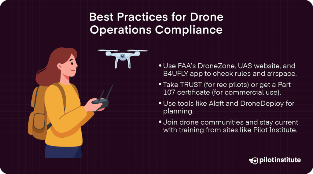
Staying Informed on Regulations
Utilize official resources, such as the FAA’s DroneZone and UAS website, for updates. Read Advisory Circulars and other regulatory amendments.
Engaging with the drone community is also helpful. Join industry associations, such as the Association for Unmanned Vehicle Systems (AUVSI). Participating in forums can also help share knowledge.
Pilot Institute also has a wide variety of drone courses to keep you up-to-date on the latest regulatory changes, technology updates, and best practices.
Pre-Flight Planning Tools
There are many helpful apps and other software that help in pre-flight planning.
One of the top recommendations is the B4UFLY app, which, according to the FAA is a “mobile application is a partnership” between the FAA and Aloft Technologies (formerly Kittyhawk)” that “helps recreational flyers know whether it is safe to fly their drone, as well as increases their situational awareness.” (AIM, Chapter 11, Section 8).
One of the top recommendations is the B4UFLY app. According to the FAA (AIM, Chapter 11, Section 8), the B4UFLY “mobile application is a partnership” between the FAA and Kittyhawk. (Kittyhawk is now known as Aloft Technologies.) The app “helps recreational flyers know whether it is safe to fly their drone, as well as increases their situational awareness.”
Other impressive planning tools are found in Airloft, which also facilitates LAANC requests, and DroneDeploy for comprehensive mission planning.
Conducting regular airspace checks visually and with current flight data also helps ensure safe operations. Even in familiar areas, verify airspace status before each flight. Remember, airspace classifications and restrictions can change due to temporary conditions.
Training and Certification
Obtaining Proper Certification helps pilots fly safely and with full compliance.
Commercial pilots should obtain the Part 107 Remote Pilot Certificate, which requires an initial test and recurrent training. We have some excellent study tools and practice tests right here on Pilot Institute.
It is important to remember that even with Part 107 certification, “to fly under 14 CFR Part 107, the UAS must weigh less than 55 pounds and the operator (called a remote pilot) must pass a knowledge test. Also, the UAS must be registered.” (AIM, Chapter 11, Section 2). Just make sure to keep up to date with Part 107 changes.
For recreational flyers, it is advised to complete The Recreational UAS Safety Test (TRUST). This module was developed in consultation with multiple UAS stakeholders and through interested party feedback. TRUST is available electronically, has no minimum age limit, and is provided by volunteer test administrators, vetted by the FAA” (AIM, Chapter 11, Section 2). Again, Pilot Institute has some great study tools to ensure your success on the TRUST exam.
In fact, it is always beneficial to expand your education to increase competency and skill sets. Pilots can pursue additional training for advanced operations, such as BVLOS flights or expanded operations over people.
Conclusion
The need for waivers to fly in controlled airspace has decreased significantly thanks to LAANC and recent regulatory changes. Pilots can now obtain near-instant authorization for many standard operations. However, understanding when a waiver is still necessary is crucial for compliance and safety.
Leveraging LAANC and other resources helps ensure compliance and safety in all your operations. If a waiver is needed, make sure to initiate the application process early to accommodate long processing times.