-
Key Takeaways
-
Understanding Atmospheric Pressure
-
The Difference Between High and Low-Pressure Systems
-
Interactive: How High and Low-Pressure Systems Work
-
Low-Pressure Systems
- Vertical Movement
- Rotation (The Coriolis Effect)
- Flying in Low-Pressure Systems
-
High-Pressure Systems
- Vertical Movement
- Rotation (The Coriolis Effect)
- Flying in High-Pressure Systems
-
Staying Safe in High and Low-Pressure Systems
- Pre-Flight Checks
- Stay Informed
- Use Onboard Tools
- Plan Your Route
-
Frequently Asked Questions
- What Is the Difference Between a High and Low-Pressure System?
- What Is Considered High or Low Barometric Pressure?
- Does Low Pressure Always Mean Bad Weather?
- How Do High and Low-Pressure Systems Affect Flying?
-
Conclusion
Last Updated:
Almost 10% of General Aviation accidents happen because of weather.
What’s the key to preventing them?
Understanding weather systems.
But for many pilots, high and low-pressure systems remain a mystery.
We’re here to help.
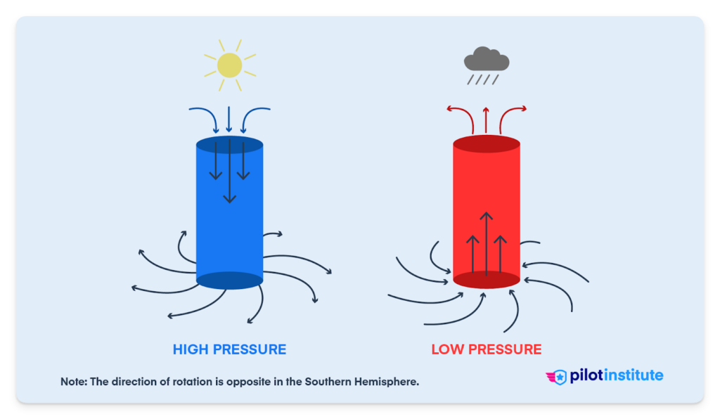
In a high-pressure system, air sinks toward the ground, bringing stable air, clear skies, and fair weather. In a low-pressure system, air rises, bringing clouds, precipitation, and unstable weather.
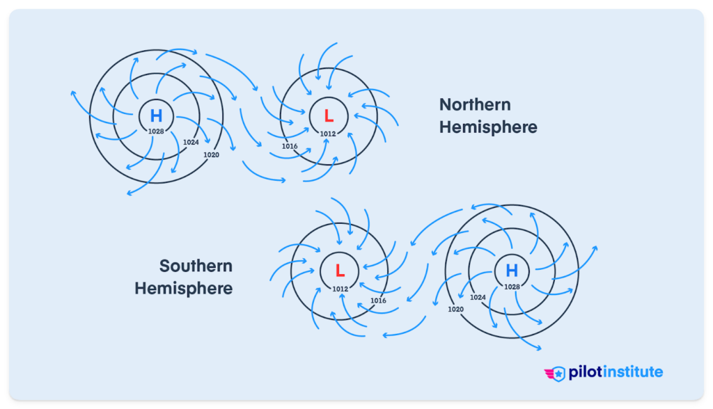
Air always moves from high pressure to low pressure. In the Northern Hemisphere, high-pressure systems rotate clockwise and low-pressure systems rotate counterclockwise, due to the Coriolis effect. South of the equator, the pattern flips.
In this article, we’ll explain everything you need to know about the differences between high and low-pressure systems.
Ready to become a safer pilot?
Key Takeaways
- Atmospheric pressure, or air pressure, is the force exerted onto a surface by the weight of the air above it.
- We call the areas with lower pressure low-pressure systems. We call areas with higher pressure high-pressure systems.
- Air descends toward the ground in high-pressure systems. This creates stable atmospheric conditions and fair weather.
- In low-pressure systems, air rises, leading to more unstable air and poor weather.
- In the Northern Hemisphere, high-pressure systems rotate clockwise. Low-pressure systems rotate counterclockwise. This rotation is due to the Coriolis effect. It is the opposite in the Southern Hemisphere.
Free Private Pilot Study Sheet
Grab a printable PDF that highlights must-know PPL topics for the written test and checkride.
- Airspace at-a-glance.
- Key regs & V-speeds.
- Weather quick cues.
- Pattern and radio calls.
Understanding Atmospheric Pressure
To understand the difference between high and low-pressure systems, we have to understand atmospheric pressure in general.
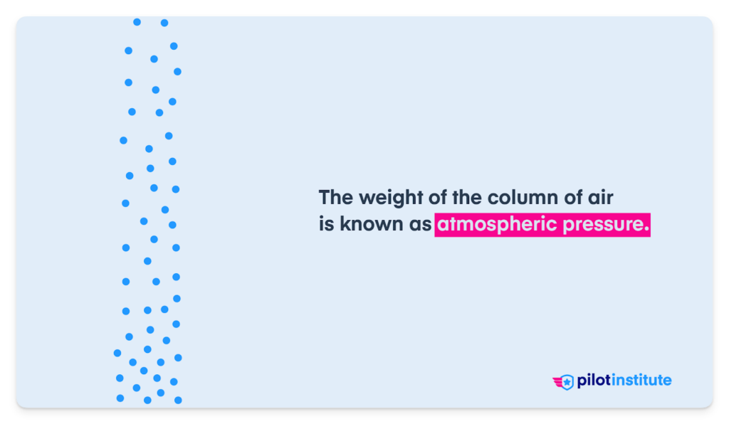
Atmospheric pressure, also called air pressure, is the force exerted onto a surface by the weight of the air above it.
Imagine a column of air stretching from the ground up to the edge of space. The weight of this entire column creates pressure on the Earth’s surface. That pressure is what we call atmospheric pressure.
At any given moment, some areas on the Earth’s surface have higher pressure compared to their surroundings, and some have lower pressure.
We call the areas with lower pressure low-pressure systems. We call areas with higher pressure high-pressure systems.
In the US, we measure atmospheric pressure in inches of mercury (inHg) and millibars (mb).
Remember altimeter settings like “29.92”? That’s 29.92 inches of mercury (inHg).
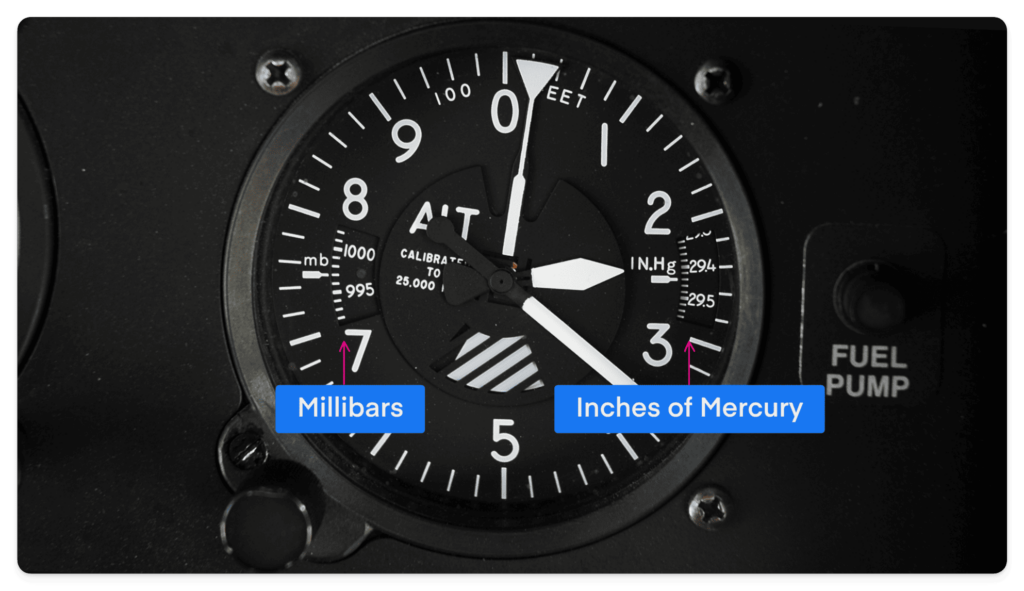
The rest of the word uses the hectopascal (hPa).
One hectopascal (hPa) equals one millibar (mb), so it’s practically only a difference in name.
The Difference Between High and Low-Pressure Systems
The most fundamental difference between high and low-pressure systems is the movement of air.
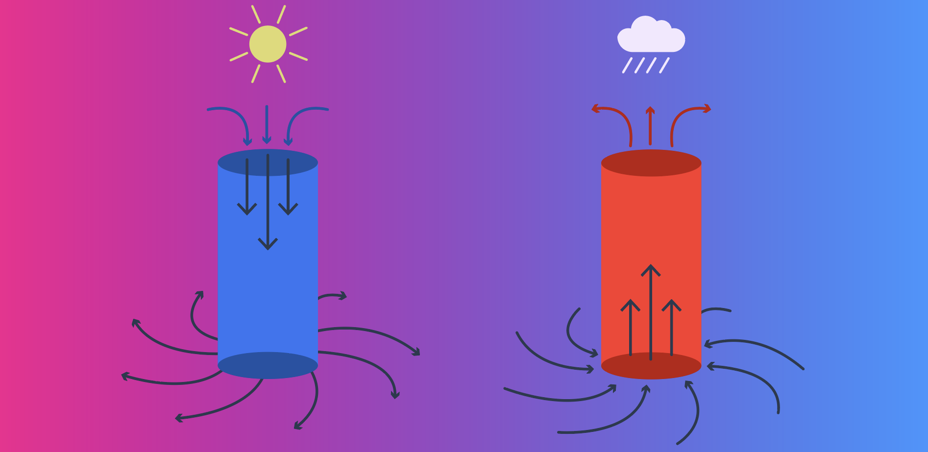
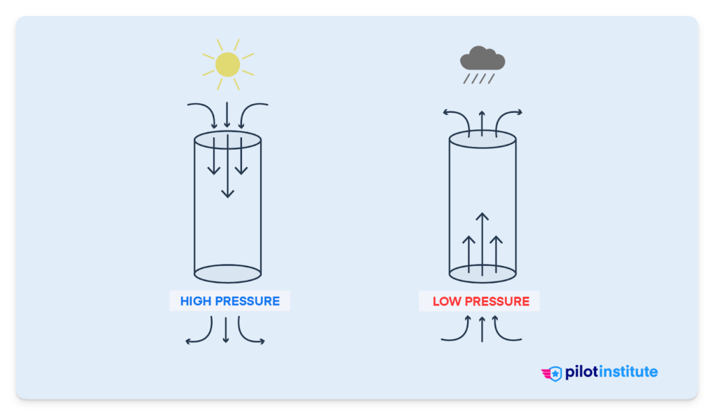
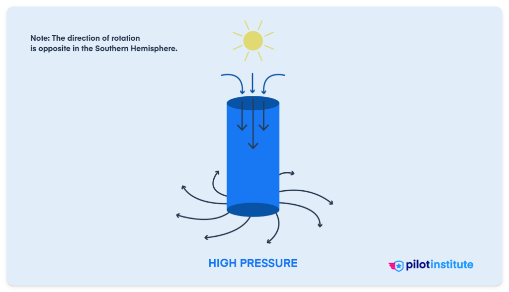
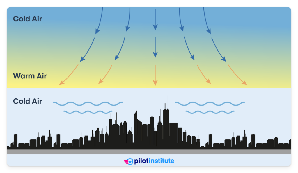
In high-pressure systems, air descends toward the ground, resulting in stable atmospheric conditions.
In low-pressure systems, air rises, leading to more unstable atmospheric conditions.
Air also always moves from high pressure to low pressure. In other words, air comes together in areas of low pressure and goes away from areas of high pressure.
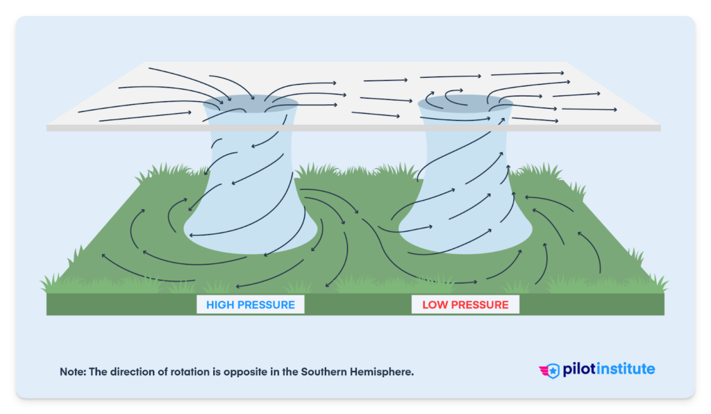
There’s also a difference in rotation.
In the Northern Hemisphere, a high-pressure system rotates clockwise. A low-pressure system has a counterclockwise rotation. This rotation is due to the Coriolis effect (more on that later).
All of these characteristics come together to create one fundamental difference between high and low-pressure systems:
- High-pressure systems bring fair weather, clear skies, and calm air.
- Low-pressure systems bring unstable air, clouds, and precipitation – ranging from light drizzle to heavy storms.
Now, let’s explore each pressure system in detail.
Interactive: How High and Low-Pressure Systems Work
High vs Low Pressure — Interactive Explainer
Pick a system and a hemisphere to see how the air actually moves — and what kind of flying weather it brings.
Top-Down View (Surface Winds)
Clockwise circulation, air spiraling outward (divergence).
Cross-Section (Vertical Motion)
Sinking air warms by compression — clouds dissipate, skies stay clear.
High Pressure (Anticyclone)
- Circulation
- Clockwise in the Northern Hemisphere, counterclockwise in the Southern Hemisphere.
- Air movement
- Air sinks (subsides) and diverges outward at the surface.
- Typical weather
- Clear skies, light winds, and stable air. Sinking air warms by compression, which suppresses cloud formation.
- Watch out for
- Temperature inversions that trap haze, smoke, and pollutants — visibility can be poor under a strong, stagnant high.
- For pilots
- Generally smooth, fair-weather flying, but check visibility and expect an inversion layer on climb-out.
In the Northern Hemisphere, this high spins clockwise.
Low Pressure (Cyclone)
- Circulation
- Counterclockwise in the Northern Hemisphere, clockwise in the Southern Hemisphere.
- Air movement
- Air converges inward at the surface and rises.
- Typical weather
- Clouds, precipitation, and unstable air. Rising air cools, moisture condenses, and weather deteriorates.
- Watch out for
- Lowering ceilings and visibility, turbulence, and stronger winds — pressure gradients around lows are usually tighter.
- For pilots
- Plan for deteriorating conditions, and remember your altimeter: flying from high to low pressure without an updated setting means you're lower than indicated.
In the Northern Hemisphere, this low spins counterclockwise.
Test Yourself
Question 1 of 5
Interactive explainer by Pilot Institute. Simplified model for training purposes — always get a full weather briefing before flight.
Low-Pressure Systems
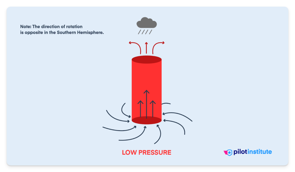
Low-pressure systems are atmospheric zones where the air pressure is lower than that of the surrounding areas.
When you hear low-pressure, think of “bad” weather.
Low-pressure systems often create challenging conditions for pilots.
The closer you are to the center of a low-pressure system, the more significant the weather (wind, rain, etc.) will be.
Vertical Movement
Remember how air always moves from high to low pressure? Because of this tendency, air converges toward the center of a low-pressure system.
The air also rises because of the reduced pressure.
Think of a low-pressure system as a vacuum that “sucks” air up and toward the center.
The rising of the air is the biggest reason why low-pressure systems bring clouds and precipitation.
As the air rises, it cools, and moisture within it condenses to form clouds (and rain or snow).
Rotation (The Coriolis Effect)
In the Northern Hemisphere, low-pressure systems rotate counterclockwise due to the Coriolis effect.
The Coriolis effect is the apparent movement of wind due to the spinning of the Earth.
Because of the Earth’s rotation, winds don’t move in a straight line from point A to point B.
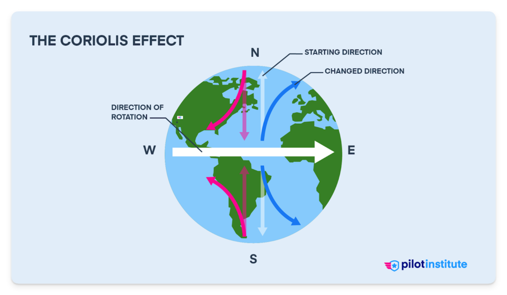
Instead, in the Northern Hemisphere, winds curve to the right. This makes wind rotate counterclockwise around areas of low pressure and clockwise around areas of high pressure.
In the Southern Hemisphere, it’s the opposite.
Think of it like throwing a ball to someone on the opposite end of a merry-go-round. The ball won’t go straight toward them – it will curve because you’re spinning.
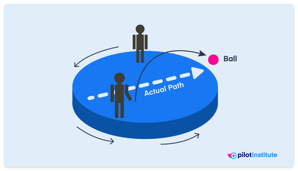
That’s what happens to moving wind on our spinning merry-go-round, the Earth.
Flying in Low-Pressure Systems
For pilots, a low-pressure system isn’t just a rainy day.
Low-pressure systems can cause turbulence because of unstable air. These systems can also cause clouds and precipitation.
The real danger of low-pressure systems?
They can also bring potentially dangerous conditions like icing or thunderstorms.
In a low-pressure system, the air is unstable. Interestingly, this leads to good visibility outside of clouds and precipitation.
Flying near or through these systems requires careful planning and keen awareness. Sometimes, alternate decision-making like rerouting or delaying a flight is necessary.
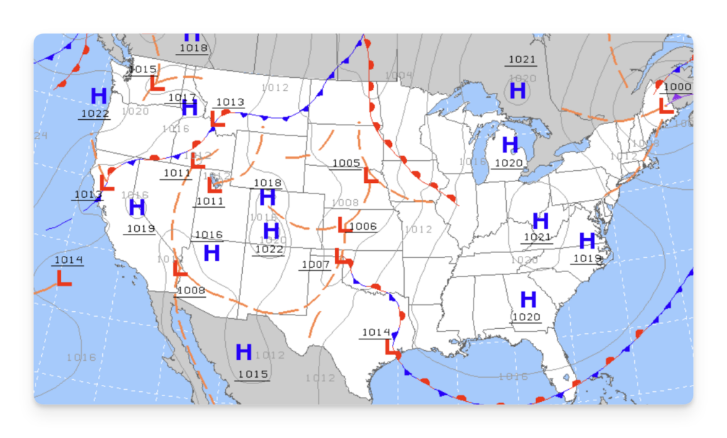
Pilots rely on surface analysis charts that show the position of high and low-pressure systems. These charts help pilots understand general weather conditions and trends across a wide area.
High-Pressure Systems
High-pressure systems are atmospheric zones where the air pressure is higher than that of the surrounding areas.
High-pressure systems often feature stable air and fair weather conditions.
When you hear high pressure, think of “good” weather.
Vertical Movement
Unlike the rising air in low-pressure systems, high-pressure systems feature descending air.
Air in a high-pressure system also diverges. In other words, the air moves down and away from the center (toward the lower pressure surrounding it).
Think of a high-pressure system as a blow-dryer that blows air down and away from the center.
The sinking of the air keeps it warmer and suppresses cloud formation.
Rotation (The Coriolis Effect)
Remember the Coriolis effect?
In the Northern Hemisphere, the air in high-pressure systems moves in a clockwise direction due to this effect. In the Southern Hemisphere, it’s the opposite, with air rotating counterclockwise.
Flying in High-Pressure Systems
High-pressure systems mean less turbulence. The stable air associated with these systems reduces the vertical movement of air masses, making for smoother rides.
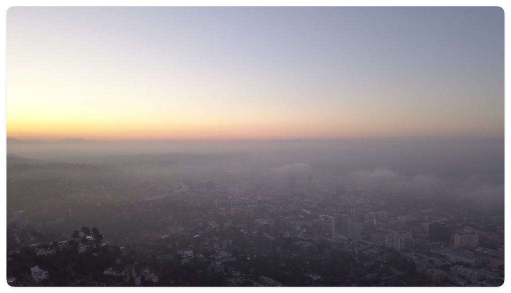
The clear skies of a high-pressure system can also lead to rapid cooling of the Earth’s surface, especially during the night. This can result in morning ground fog or frost on aircraft surfaces.
While high-pressure systems often promise clear skies, there’s a catch that you should be aware of.
Precipitation, such as fog or haze, doesn’t dissipate easily in the stable air of high-pressure systems.
Sometimes, high-pressure systems can lead to temperature inversions. A temperature inversion is when the temperature increases with altitude rather than decreasing. This can cause reduced visibility and affect aircraft performance.
Generally, the visibility in high-pressure systems isn’t that poor unless smoke is present from a nearby wildfire, for example.
Staying Safe in High and Low-Pressure Systems
Now that you understand the difference between high and low-pressure systems, how do you go about navigating them safely?
Here are a few tips to keep in mind.
Pre-Flight Checks
High-pressure systems can lead to morning frost. In low-pressure systems, wet conditions can cause icing.
Check for frost, ice, or any anomalies during your preflight, and pay special attention if a large pressure system is present.
Stay Informed
Monitor METARs, TAFs, and other weather updates. Changes in pressure systems can be swift, and having the latest data ensures you’re not caught off guard.
Additionally, learn to interpret surface analysis charts. These charts help you anticipate the movement of atmospheric pressure systems. They’re key to getting a “bigger picture” of the weather.
Use Onboard Tools
Make use of modern in-flight weather monitoring tools such as the FAA’s NextGen ADS-B network or SiriusXM’s satellite weather service.
These tools offer real-time weather updates (even via your tablet). You can use them to identify and avoid turbulence or bad weather.
Depending on the type of aircraft you fly, you may even have onboard weather radar capabilities. Weather radar is a fantastic way to ensure you navigate significant weather conditions safely.
Plan Your Route
Anticipate the movement of low-pressure systems and adjust your route accordingly.
In general, try to fly around strong low-pressure systems.
If the low-pressure system isn’t significant, consider making altitude and course adjustments to avoid areas of icing and turbulence.
Sometimes, a small change in altitude and course can make a significant difference in flight conditions.
Frequently Asked Questions
What Is the Difference Between a High and Low-Pressure System?
In a high-pressure system, air sinks toward the ground and brings stable, fair weather. In a low-pressure system, air rises, cools, and forms clouds and precipitation. That one difference in air movement drives everything else, from wind and rotation to the kind of flying weather you can expect.
What Is Considered High or Low Barometric Pressure?
Standard sea-level pressure is 29.92 inches of mercury (inHg), which equals 1013 millibars. Readings above that lean toward high pressure, and readings below lean toward low. The terms are relative, so a system is only “high” or “low” compared to the air around it.
Does Low Pressure Always Mean Bad Weather?
Not always, but usually. Low-pressure systems bring clouds, precipitation, and turbulence from rising, unstable air. Outside of the clouds and rain, though, visibility is often good, because that same unstable air mixes out haze and stagnation.
How Do High and Low-Pressure Systems Affect Flying?
High-pressure systems usually bring smooth air and clear skies, but they can trap fog, haze, and morning frost. Low-pressure systems bring turbulence, low ceilings, and hazards like icing or thunderstorms.
Check current METARs and TAFs before every flight to stay ahead of changing conditions. And remember the altimeter rule: flying from a high into a low without a new setting leaves you lower than indicated.
Conclusion
Now that you have a solid grasp of pressure systems, you need to learn how to receive weather information in flight.
Where should you start?
By understanding the difference between ATIS, AWOS, and ASOS.
Read our article on ATIS, AWOS, and ASOS Explained.