-
The Difference between ATIS, AWOS, and ASOS
-
Automated Terminal Information Service (ATIS) Explained
- ATIS vs. AWOS and ASOS
- What Kind of Information Can You Get from an ATIS?
- Automatic ATIS
-
Automated Weather Observing System (AWOS) Explained
- AWOS Levels
-
Automated Surface Observing System (ASOS) Explained
- ASOS and the National Weather Service
-
Where to Find ATIS, ASOS, or AWOS Frequencies
- Airport Diagrams
- Sectional Charts
- Approach Plates
- FAA Directory
-
What’s the Difference between a METAR and ATIS/ASOS/AWOS?
- METAR vs. ATIS
- METAR vs. ASOS/AWOS
-
What is AWSS?
-
Summary
As a pilot, keeping a keen eye on the weather is essential for safe and smooth flying. Thankfully, we have a trio of trusty weather reporting systems to keep us informed and prepared:
- Automatic Terminal Information Service (ATIS)
- Automated Weather Observing System (AWOS)
- Automated Surface Observing System (ASOS)
But getting tangled up in this web of acronyms and systems is easy, and their similarities make it difficult to understand their differences.
Fear not; we’re here to make sense of them all.
The Difference between ATIS, AWOS, and ASOS
ATIS, AWOS, and ASOS all provide crucial weather updates, but there’s a clear difference.
ATIS delivers essential weather and airport information at controlled airports.
AWOS and ASOS both report weather conditions, but don’t deliver airport information like the ATIS. AWOS stations report weather information every minute and are operated by the Federal Aviation Administration (FAA). ASOS stations are more advanced than AWOS stations and are typically operated by the National Weather Service (NWS).
In other words (with some exceptions that we’ll dive into later), ATIS reports weather and airport information at controlled airfields, while ASOS is a more advanced version of AWOS, which reports weather information automatically at controlled and uncontrolled airports.
| AWOS | ASOS | ATIS | |
| Update Frequency | Every minute | Every minute | Every hour |
| Comprehensiveness | Least comprehensive | More comprehensive | Most comprehensive |
| Availability | Towered and non-towered airports | Towered and non-towered airports | Only towered airports |
Automated Terminal Information Service (ATIS) Explained
The Automated Terminal Information Service (ATIS) is your best friend when approaching an airport. It’s a continuous broadcast of important details you need to know.
What kind of details?
Well, think of ATIS as your personal airport news channel. It gives you the current weather, active runways, available approaches, and any notable conditions or changes.
But ATIS isn’t real-time. The broadcasts typically update every hour unless there’s a significant weather or operation change. So, always double-check the ATIS code (usually a letter) to make sure you have the latest information.
You might be wondering how to access the ATIS. It’s simple. You just tune into the designated ATIS frequency for your specific airport. Then sit back, listen, and note down the essential points.
ATIS is the most comprehensive of the three because you’ll receive weather and airport information. More on that later.
ATIS vs. AWOS and ASOS
Remember, the Automated Terminal Information Service (ATIS) isn’t just about weather. It tells you about active runways, NOTAMs, and other crucial details, along with the weather.
On the flip side, the Automated Weather Observing System (AWOS) and Automated Surface Observing System (ASOS) are purely weather-focused. They are automated systems that record and broadcast meteorological data.
With an ATIS, there is usually a human involved in broadcasting the information. A new ATIS report is issued every hour at 55 minutes past the hour while the control tower is open.
At some airports, when the control tower closes, the ATIS turns off too. Usually, the ATIS experiences a bit of an identity crisis and changes over to an AWOS or ASOS until the tower opens again.
Here’s the takeaway: ATIS gives you the big picture at airports with a control tower, including the weather. AWOS and ASOS give you weather data but not additional airport-specific info and are updated automatically and more frequently than the ATIS.
What Kind of Information Can You Get from an ATIS?
Firstly, you’ll get the ATIS information identifier, a letter from the phonetic alphabet. This letter changes with each update to help you ensure you’re getting the latest info.
You’ll also get information about the weather conditions. Expect to hear about the wind direction and speed, visibility, temperature, dew point, and altimeter setting.
But ATIS isn’t just a weatherman. It also shares vital operational data. You’ll hear about the active runways, available instrument approaches, and critical NOTAMs.
Sometimes, you may even get special instructions or airport advisories, like taxiway closures or construction areas.
Here’s a real-life example of a typical ATIS broadcast:
“Danbury Tower ATIS information India, one-two-five-three Zulu,
Wind two-four-zero at five,
Visibility ten,
Scattered clouds one-zero thousand,
Temperature two-one dewpoint one-zero,
Altimeter three-zero zero-niner,
Runway two-six in use for arrivals and departures,
Arriving aircraft, expect the visual approach,
Use caution for bird activity in the vicinity,
For further information, contact flight service frequencies,
Advise on contact that you have ATIS information India.”
Automatic ATIS
There are ATIS services that are somewhat automated to decrease the workload of Air Traffic Controllers.
The most common form of automatic ATIS services is a synthetic voice reading the ATIS. Traditionally, an Air Traffic Controller needs to record the ATIS message (the one that will broadcast on the frequency) every hour. With an automatic ATIS, controllers only need to check the information and automatically recorded the voice.
While human input is still required (checking the ATIS, turning the automated system off when the tower closes, etc.), automated ATIS services make the process much more efficient.
You may also come across ATIS frequencies labeled “D-ATIS.”
D-ATIS, also known as “digital-ATIS” or “data-link ATIS,” is a newer, digital version of the traditional ATIS. It delivers essential airport information digitally, straight into the cockpit. Instead of manually tuning into a frequency and listening to a looped recording, pilots with ATIS-D capable aircraft receive text-based updates automatically. This system increases readability and reduces potential errors from misheard information.
Automated Weather Observing System (AWOS) Explained
AWOS is all about weather, and nothing but weather. It’s an automated system that measures and broadcasts current weather data. It’s like having a personal weather station at your fingertips.
What kind of information will AWOS deliver? That depends on the AWOS level.
AWOS Levels
You might hear AWOS referred to with different ‘levels’ or ‘types.’ These categories are there to denote the kind of information each AWOS station can provide. Let’s break it down.
AWOS I is your entry-level system. It provides basic weather information: wind speed, wind direction, temperature, dew point, and altimeter setting.
But sometimes, you need more, right? That’s where AWOS II comes in. It offers everything AWOS I does but with an additional feature: visibility readings.
Then, we have AWOS III. In addition to all the AWOS II data, it also reports sky conditions, cloud ceiling height, and precipitation type.
AWOS IV are top-tier stations that go even further, adding sensors for runway surface conditions and freezing rain.
Within the four AWOS levels, there are additional categories.
Here’s the full list of what each AWOS level is capable of reporting:
- AWOS A: barometric pressure, altimeter setting.
- AWOS AV: Altimeter setting and visibility.
- AWOS I: wind speed and gusts, wind direction, variable wind direction, temperature and dew point, altimeter setting, density altitude.
- AWOS II: AWOS I parameters + visibility, variable visibility.
- AWOS III: AWOS II parameters + sky condition, cloud ceiling height, liquid precipitation accumulation.
- AWOS III P: AWOS III parameters + precipitation type identification (rain, snow, drizzle).
- AWOS III T: AWOS III parameters + thunderstorm detection.
- AWOS III P/T: AWOS III parameters + precipitation type identification, thunderstorm detection.
- AWOS IV Z: AWOS III P/T parameters + freezing rain detection (previously known as AWOS III PTZ).
- AWOS IV R: AWOS III P/T parameters + runway surface condition.
- AWOS IV Z/R: AWOS III P/T parameters + freezing rain detection, runway surface condition.
You’ll rarely find AWOS A, AWOS AV, AWOS I, or AWOS II stations these days. Most AWOS stations are AWOS III P or AWOS III P/T.
AWOS stations update every minute, 24 hours a day, seven days a week. Pretty neat!
Automated Surface Observing System (ASOS) Explained
ASOS is similar to AWOS in that it is automated and provides weather information. The information an ASOS provides on frequency is practically the same as an AWOS III P/T.
Most ASOS stations update every minute, but you may find some that update less frequently.
ASOS stations are more advanced than AWOS and are used for more than just broadcasting current weather information. For example, ASOS stations play a vital role in generating forecasts (like TAFs).
Furthermore, ASOS systems do more than just report the weather to pilots. They also play a crucial role in maintaining the National Weather Service’s climatological database.
ASOS and the National Weather Service
The National Weather Service (NWS) relies on ASOS stations for collecting critical meteorological data. This data helps meteorologists forecast weather patterns and track climate changes over time.
The NWS operates ASOS stations, unlike AWOS stations, which are under the FAA’s control.
The NWS uses ASOS information to support public, aviation, and marine forecasts. Additionally, it assists in severe weather warnings and many other weather-related operations.
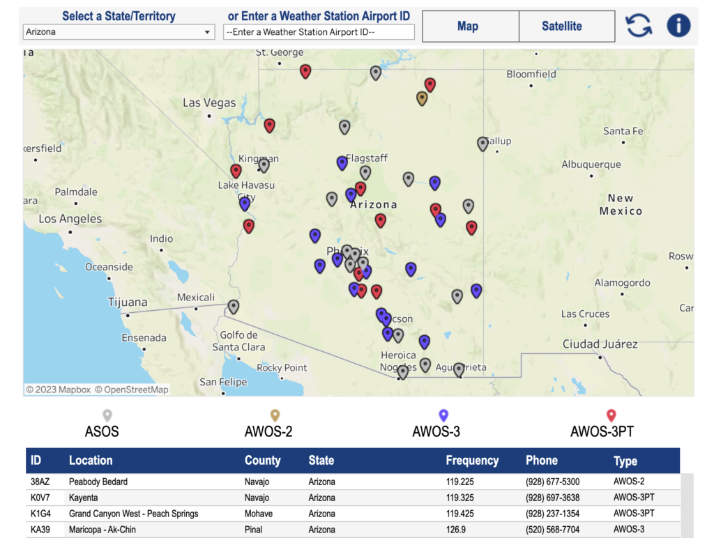
Where to Find ATIS, ASOS, or AWOS Frequencies
You might be puzzled about how to identify if an airport has an ATIS, ASOS, or AWOS frequency.
Luckily, there are several ways that you can find ATIS, ASOS, or AWOS frequencies.
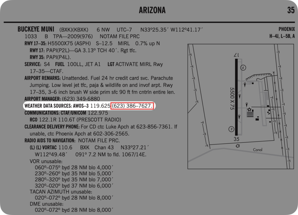
Airport Diagrams
The easiest way to identify if an airport has an ATIS, ASOS, or AWOS frequency is to look at the airport diagram.
At larger airports where you’ll find ATIS frequencies, you’ll have a dedicated airport diagram with the relevant frequencies listed.
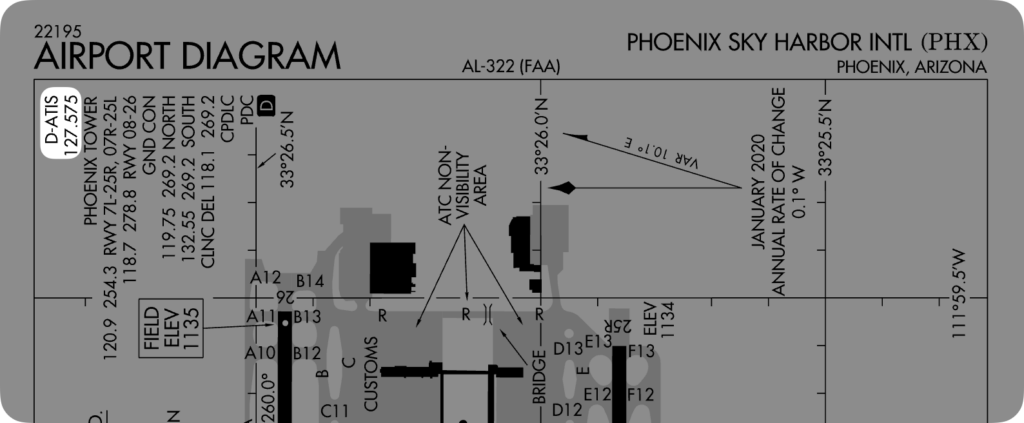
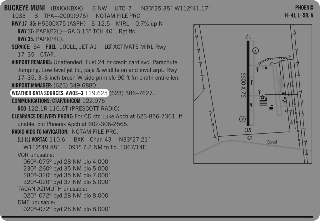
At smaller airports (where AWOS or ASOS stations are more common), you’ll find the frequency under “weather data sources” in the FAA’s airport directory.
Sectional Charts
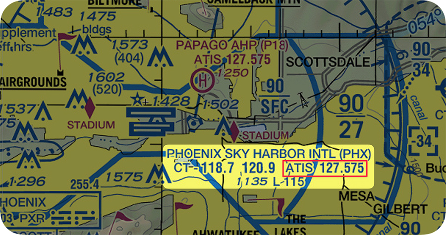
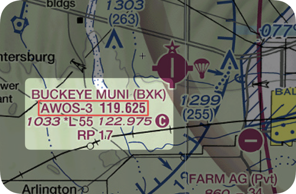
Sectional charts are like treasure maps. They provide a ton of valuable information, including topography, airspace, and airport data. And yes, that includes ATIS, ASOS, or AWOS frequencies.
Just locate your airport on the sectional chart, and you’ll find the ATIS, ASOS, or AWOS frequency listed next to it.
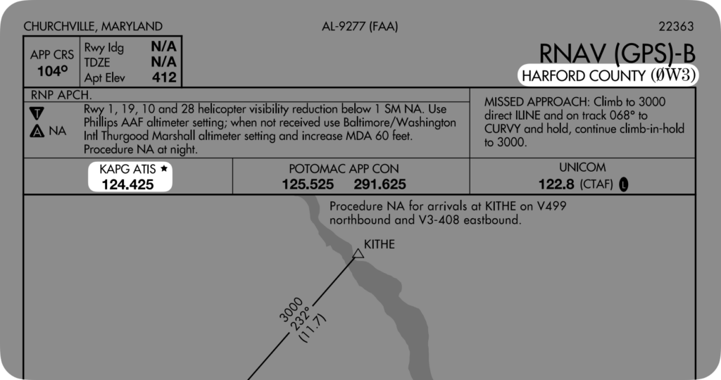
Approach Plates
Similar to the airport diagrams, airport approach plates will feature relevant ATIS, AWOS, or ASOS frequencies.
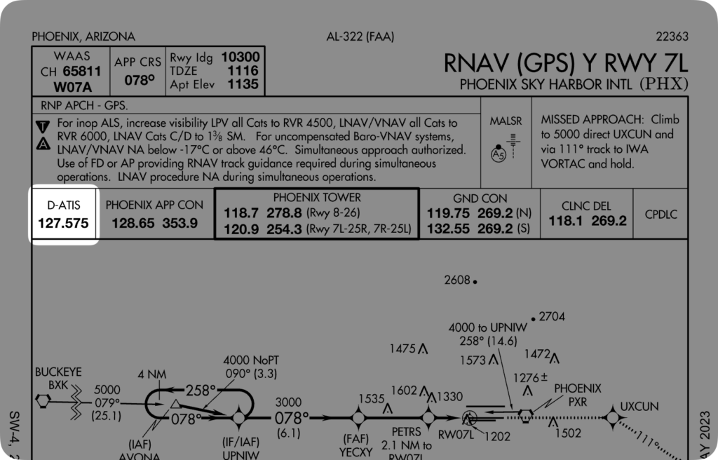
Sometimes, if the airport doesn’t have an ATIS, AWOS, or ASOS station, you’ll see the nearest airport with an ATIS or AWOS/ASOS frequency listed on the approach plate
FAA Directory
The FAA has a great (ASOS/AWOS) directory, which lets you search for any ASOS or AWOS station, and even see the AWOS level!
The phone numbers listed in the directory (and on the airport directory) allow you to call the associated ATIS, ASOS, or AWOS station and listen to a digital readout of the weather (or ATIS).
Don’t rely on this for most stations, though, as we’ve found many of the phone numbers no longer work, particularly for the smaller airports.
What’s the Difference between a METAR and ATIS/ASOS/AWOS?
By this point, you may wonder how METARs (Meteorological Aerodrome Reports) fit into the picture.
The primary difference between a METAR and ATIS/ASOS/AWOS is where you receive the information. Typically, you’ll receive ATIS/ASOS/AWOS information from a radio frequency or data link, whereas you’ll typically receive METAR information from a preflight briefing.
If you’re still confused, that’s okay – to understand the fundamental differences, let’s look at a METAR compared to each of the three weather information stations.
METAR vs. ATIS
The confusion between METAR and ATIS often comes from the fact that both provide weather information. Despite this, they serve different purposes and are used in different scenarios.
METAR is a coded weather report, typically issued every hour, that gives you detailed current weather conditions at a specific airport. It includes data like temperature, dew point, wind direction and speed, visibility, cloud cover, and pressure.
ATIS, on the other hand, is a continuous broadcast of recorded aeronautical information, updated hourly. It not only provides weather information from the latest METAR but also crucial details about the airport’s active runways, instrument approaches, and any notable conditions or temporary changes.
In short, use METAR for weather updates, and ATIS for comprehensive airport info.
METAR vs. ASOS/AWOS
The distinctions among METAR, ASOS, and AWOS lie in their functions and how they generate weather data.
ASOS/AWOS systems provide real-time weather data, including many of the same elements as a METAR.
But ASOS/AWOS stations update more frequently than METARs and effectively provide real-time weather data.
In other words:
- METAR: An hourly weather report that provides current conditions at an airport (not broadcast on a frequency unless part of an ATIS).
- ASOS/AWOS: Automated weather stations offering real-time weather data broadcast on a radio frequency.
What is AWSS?
You may come across the term “AWSS” or “Automated Weather Sensor System.”
Don’t worry; this one is easy to explain.
AWSS is an older version of AWOS. There are no more AWSS stations in service today, and previous AWSS stations have all been converted to AWOS stations.
Summary
That was quite the ride, wasn’t it?
But now, you’ll never be confused about the differences between ATIS, AWOS, ASOS, and METARs ever again.
Here’s a quick summary of what we covered:
- ATIS provides comprehensive airport and weather information and updates every hour. AWOS and ASOS offer weather data without additional airport information. AWOS and ASOS systems can be found at both towered and non-towered airports. ATIS, however, is only available at towered airports.
- AWOS, which operates under the FAA, provides weather updates every minute, the detail of which is determined by the AWOS level.
- ASOS, managed by the National Weather Service, also updates weather data frequently and contributes significantly to the US climatological database.
- Although METARs also provide weather updates, their function differs from ATIS, AWOS, and ASOS. METARs are coded weather reports issued every hour, typically accessed via preflight briefing. In contrast, ATIS, AWOS, and ASOS broadcast information through a radio frequency or data link.
- AWSS is an older version of AWOS that is no longer used.