-
Key Takeaways
-
What Is a METAR?
-
How Do You Decode a METAR?
- 1) The ICAO Designator – KBWI
- 2) Date and Time – 082330Z
- 3) Automated Observation – AUTO
- 4) Wind Information – 21010KT
- 5) Visibility – 5SM
- 6) Precipitation – DZ
- 7) Cloud Cover – OVC010 BKN020
- 8) Temperature and Dew Point – 10/8
- 9) Altimeter Setting – A3000
-
Practicing How to Decode a METAR
-
Conclusion
Last Updated:
When flying an airplane, you become a part of the air around you. So, you will want to know what the air and prevailing weather conditions are doing.
Forget checking your phone apps or the TV. You will want detailed and accurate weather information. The best way to do that is to read a METAR.
Learning how to read a METAR can be tricky. Today we will offer you some easy-to-follow guidance and some practical examples. Let’s jump right in.
Key Takeaways
- A METAR is a standardized aviation weather report for a specific airport.
- Decoding a METAR involves reading wind, visibility, cloud cover, and temperature.
- METARs use abbreviations but become easy to read with practice.
- Pilots use METARs for flight safety, runway selection, and weather planning.

Private Pilot
Study Sheet

Grab a printable PDF that highlights must-know PPL topics for the written test and checkride.
- Airspace at-a-glance.
- Key regs & V-speeds.
- Weather quick cues.
- Pattern and radio calls.
What Is a METAR?
METAR is an abbreviation for “Meteorological Aerodrome Report”. It is a weather report written specifically for aviators and follows a standard format. It includes key information specific to each aerodrome and data such as wind speed and direction, visibility, cloud cover, and precipitation.
A METAR usually looks something like this.
KBOS 081730Z AUTO 18008KT 3SM HZ SHVC BKN020 20/16 A2993
Suppose you are used to accessing the weather via more ‘traditional’ mediums, such as an app or TV. In that case, METARS can appear a little daunting.
There are certainly no pictures in a METAR and some really important information contained within a METAR isn’t always obvious.
For example, if we were to write this METAR in plain English, it would sound something like this: –
“The weather is taken from Boston at 1730 Zulu time on the 08th of the month. The observation was provided automatically. The wind is from the south at 8 knots. The visibility is 3 statute miles. Haze has been observed, and there are showers in the vicinity, with broken clouds 2000 feet above the airport. The temperature is 20 degrees Celsius, and the dew point is 16 degrees. The altimeter setting for the aerodrome is 29.93 inches of mercury.”
Which version do you think is easier to read and more concise? If you said “the METAR in plain English,” you’d be right, but only to a point.
Once you learn how to read a METAR, reading it in its true form (like our first example above) becomes just as easy. You will be able to gain a really great overview simply by glancing at it.
Next, we’ll explore how to decode a METAR.
How Do You Decode a METAR?
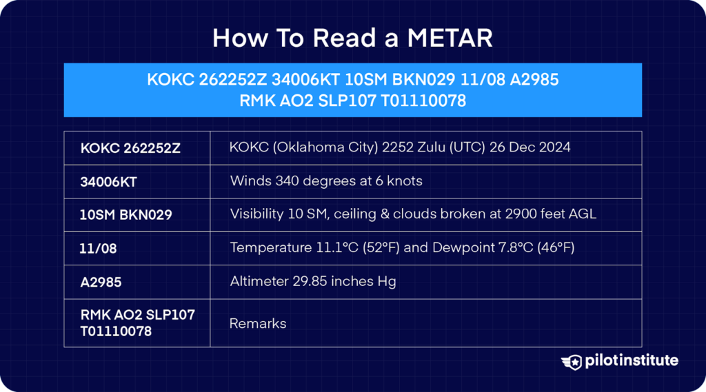
Instead of looking at a METAR as a whole, it is better to learn how to read a METAR by breaking it into little ‘chunks’.
After all, this is precisely what a METAR is.
A detailed report containing several really valuable snippets of weather information.
Here’s another for you to look at as an example. Once you’ve had a quick glance, check out our detailed METAR step-by-step breakdown below.
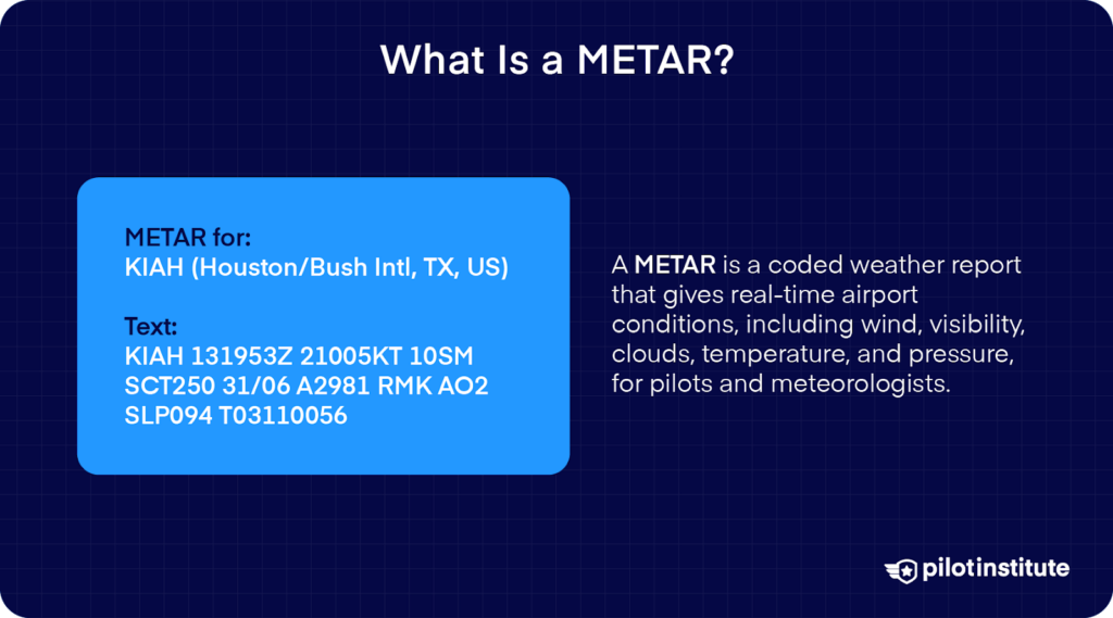
KBWI 082330Z AUTO 21010KT 5SM DZ OVC010 BKN020 10/8 A3000
Ready?
Let’s ‘chop’ the above METAR into its component parts and then take a look at each piece in turn.
- KBWI
- 082330Z
- AUTO
- 21010KT
- 5SM
- DZ
- OVC010 BKN020
- 10/8
- A3000
Here’s a detailed guide to how the above METAR is decoded piece by piece: –
1) The ICAO Designator – KBWI
METAR reports will always start with a 4 letter designator. This will match the four-letter ICAO designator of the airport in question. The above METAR corresponds to Baltimore airport. There are actually hundreds of these ICAO codes used throughout the USA.
Why it is important in a METAR – It should be obvious. You will want to know the actual weather for the airport you are flying to. Often, large cities have many airports spread far apart, so the weather might differ even though they serve the same city.
2) Date and Time – 082330Z
How recent is the reported weather? Well, this section of the METAR will tell you. It is actually two pieces of information.
The first two numbers are the day of the month. The four following numbers are the time at which the observation was taken.
And, it is important to note that the observation times are not given in local time. Instead, they are given in Zulu time. Zulu time is the same the world over. If you want to read more about Zulu time, we have a great article here.
Why it is important in a METAR – if a METAR is long out of date, then the information contained within won’t be valid and may have changed completely in some circumstances. Generally, METARs are issued at least once per hour or more regularly if significant changes occur.
3) Automated Observation – AUTO
In today’s age of technology, computers can even be weathermen! Many airfields are festooned with various sensors and gauges, which feed into a meteorological computer. This computer will automatically issue reports at a predetermined time.
Neat, right?
If you ever see a METAR without AUTO, a real-life human being has made the observation and issued the METAR, so it will be omitted.
Why it is important in a METAR – Automated observations are useful during quiet times on aerodromes. However, they do have limits. Human observation allows for more nuanced and accurate measurements, especially if the weather changes rapidly or has a directional element, such as moving fog patches or thunderstorms in a given direction.
4) Wind Information – 21010KT
The first three digits are directional bearing. They indicate which direction the wind is coming from. It is vital to remember that this bearing will be given in degrees true, not magnetic. So there may be a difference based on the local variation.
The second two digits are the wind speed. The ‘KT’ indicates that the scale used is ‘knots’ (an abbreviated term for nautical miles per hour). The higher this number, the stronger the wind!
Pilots love knowing about the wind. Ideally, they try to land into a headwind, may tolerate crosswinds, and try to avoid significant tailwinds. To accommodate this, airports will normally choose a runway number corresponding to the general wind direction.
And here’s the thing: by knowing the wind speed and direction, you can make a really good guess at which runway will be in use based on all of the above.
Keep a good lookout for the letter “G” appearing in the wind report. This means “gusting” and indicates a wild variation in wind speeds!
Why it is important in a METAR – Landing in a strong crosswind is a tricky business. Landing in a tailwind vastly increases the runway required to slow to a safe speed.
Suppose either of these factors exceeds your ability as a pilot or the airframe limits. In that case, you’ll be able to plan to go somewhere else in good time!
5) Visibility – 5SM
This section describes the horizontal visibility at the airport. You’ll be presented with a number followed by “SM”.
What does the SM in a METAR stand for?
Quite simply, SM stands for “statute miles”. The greater this number, the further you will be able to see!
This is normally expressed as a fraction of statute miles in poor visibility.
Why it is important in a METAR – Generally speaking, to align your aircraft and land on the runway, you’ll need to be able to see it!
Most pilots of light aircraft fly VFR, requiring good visibility to navigate. Bad visibility obscures in-flight obstacles and makes navigation much more challenging. If visibility is poor according to the METAR, then you may want to avoid flying altogether until the weather clears!
6) Precipitation – DZ
A few two-letter codes are used to describe the various forms of precipitation.
In this case, “DZ” means “moderate drizzle.”
This section can be more complex. Aside from knowing the types of precipitation, you’ll often find they are preceded by a ‘descriptor.’ These descriptors add further detailed information, designed to present a fuller picture.
You can find the descriptors and the meanings of NOTAM precipitation and weather codes in alphabetical order below: –
| NOTAM CODE | Meaning |
| “-“ | Light |
| “+” | Heavy |
| FC | Funnel Cloud (“+” means Tornado) |
| BC | Patches |
| BL | Blowing |
| BR | Mist |
| DR | Drifting |
| DS | Dust Storm |
| DU | Dust |
| DZ | Drizzle |
| FG | Fog |
| FU | Smoke |
| FZ | Freezing |
| GR | Hail stones |
| GS | Snow pellets |
| HZ | Haze |
| IC | Ice crystals |
| MI | Shallow |
| PL | Ice pellets |
| PO | Sand/Dust Devils |
| PR | Partial |
| PY | Spray |
| RA | Rain |
| SA | Sand |
| SG | Snow grains |
| SH | Showers |
| SN | Snow |
| SQ | Squalls |
| SS | Sand storms |
| TS | Thunderstorms |
| VA | Volcanic Ash |
| VC | Nearby or in the vicinity |
Try out a few examples:
- +SNSH (Heavy Snow Showers)
- FZFG +FZRA (Freezing Fog and Heavy Freezing Rain)
- MIFG BR -DZ (Shallow Fog, Mist, Light Drizzle)
Why it is important in a METAR – Landing in a drizzle isn’t too big of a deal. Landing in heavy rain is a lot more challenging. To simply say it is ‘raining’ isn’t enough when it comes to aviation.
The severity and intensity of precipitation can have serious implications for flight safety. Thunderstorms, for instance, are to be avoided at all costs!
7) Cloud Cover – OVC010 BKN020
The section detailing cloud cover can sometimes be extensive and sometimes nonexistent. Each layer of cloud is given its own little section in the METAR. It has two parts in one block.
The three letters are called a ‘contraction’ (a fancy word for ‘description’) used to portray how much of the sky is covered. The numbers indicate the altitude of the cloud base in thousands of feet.
In the above METAR, the report states that the sky is overcast at 1000ft and there is a broken cloud at 2000ft.
But it’s a big sky. How do they work out how much is covered and where?
Easy. The cloud cover gives reference to the area directly above the aerodrome.
The sky will be divided into 8 equal sections, called ‘oktas’. Think of it a little like the pattern you’d find on a basketball. These are used to grade how much of the sky is clear or covered.
Check the table below for a detailed look at oktas and how they are reported in a METAR:
| Cloud Cover | Definition | Naming Convention in METAR |
| Clear | Clear | CLR |
| 1 to 2 oktas | Few clouds | FEW |
| 3 to 4 oktas | Scattered cloud | SCT |
| 5-7 oktas | Broken cloud | BKN |
| 8 oktas | Overcast | OVC |
Why it is important in a METAR – Cloud cover is a big deal. In most clouds, the visibility is zero, meaning that you should avoid clouds entirely if you are flying VFR. If the sky is only partially covered, you may be able to find a hole and navigate VFR on top.
However, beware! Many aviators have flown through a ‘fools hole’ only for the hole to close up! Cloud can easily obscure even high obstacles, not to mention stopping you from seeing other aircraft!
8) Temperature and Dew Point – 10/8
This section of the METAR gives two vital pieces of information. The first number, before the slash, will be the outside air temperature on the aerodrome, in degrees Celsius. If it is below freezing, the temperature will be preceded by an “M’ for “minus”.
The second number will be the dew point, also given in degrees Celsius.
Wait, the dew point?
Yes, this is a measure of the temperature at which the water vapor held within the air will condense and form a cloud.
As a good general rule, the smaller the difference between the outside air temperature (OAT), and the dew point, the more likely it is that a cloud will form, and the lower its base will be.
The closer the dewpoint and temperature, the higher the relative humidity.
Why is it important in a METAR? – Temperature can have significant effects on aviation. Warm temperatures decrease aircraft performance. Also, with a small temperature and dewpoint split, you run the risk of encountering carburetor icing.
9) Altimeter Setting – A3000
Last but not least, you will find the aerodrome pressure. The “A” is the giveaway, as you’ll use it to set your altimeter. The “A” will be followed by a four-digit number. This is a measure of ‘inches of mercury, with the middle decimal point removed.
“3000” means 30.00Hg
If you set this on the ground on your altimeter at the airport, the resulting reading on the altimeter should give you the height of the airport above sea level.
Why it is Important in a METAR – Setting your altimeter correctly is vital for safe flying. No other instrument will tell you how far away you are from the ground!
Most ATC units will state the altimeter pressure setting repeatedly during their transmissions to make sure you get it right. However, it is always good airmanship to regularly check the pressure setting at nearby airfields.
Often this can be achieved with a METAR.
Practicing How to Decode a METAR
Now that you’ve seen each individual part of the METAR, it is time to get good at reading them.
How might you do this?
It’s simple, just practice!
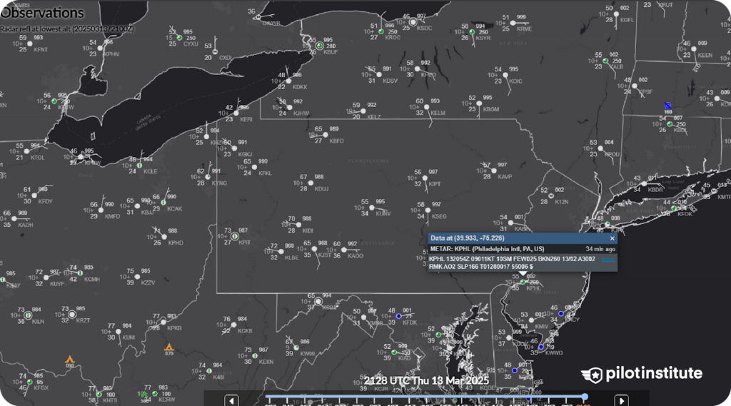
Right now, there are literally hundreds of METARS for you to read. They are reported 24 hours a day, 7 days per week. The Aviation Weather Center will allow you to quickly and easily access METARS from all over the globe. Simply insert the ICAO identifier, and you’ll be presented with the most up-to-date METAR!
Why not have a try at doing one per day? If you spot any terms you are not familiar with, the FAA has an excellent key to decoding METARS.
Conclusion
The key to knowing how to read a meteorological aerodrome report (METAR) is simply by practicing. It will become second nature with time, and even us pilots occasionally need to check a decoder guide to decipher obscure and rare weather phenomena!
Like decoding a METAR, learning to fly involves breaking things down into manageable and easy-to-understand chunks. Want to see a great example of this in action? Consider online ground school training courses to help you further your knowledge and understanding.