-
Introduction
-
Key Takeaways
-
What Is BVLOS?
- Define VLOS, EVLOS, BVLOS
- Why VLOS Limits Matter
- The Leap To BVLOS
-
BVLOS Technology Stack
- Command & Control (C2) Links
- Detect-and-Avoid (DAA) Options
- Navigation & Autonomy
- Remote ID & U-space / UTM Integration
- Ground Infrastructure
- Minimum BVLOS Checklist
- Evaluating BVLOS-Ready Drones
- Total Cost of BVLOS Ownership
-
Global Regulatory Snapshot
-
BVLOS Approval Pathway (U.S. Lens)
- Step 1: Craft A Bulletproof ConOps
- Step 2: Pick Your Waiver Model
- Step 3: Build The Safety Case with SORA
- Step 4: Submit Package
- Top Rejection Reasons
-
Mission Planning & Operational Best Practices
- Pre-Flight
- In-Flight
- Post-Flight
- Safety Management System Integration
-
Part 108 (What’s Changing and What to Do Now)
-
Conclusion
Introduction
Drone operations are about to get an exciting facelift with the coming of Part 108, welcoming Beyond Visual Line of Sight (BVLOS) as a new normal. But that day hasn’t come quite yet.
Until Part 108 rolls out, there are other pathways to being approved for BVLOS operations. From Detect-and-Avoid and redundant command-and-control to hard geofencing, BVLOS operations have a lot more technical requirements and safety procedures than traditional visual line of sight (VLOS) flights.
Let’s break down what BVLOS requires now, the systems regulators expect to see, and how to navigate the waiver process without costly missteps.
Key Takeaways
- The current framework for BVLOS requires operators to file for FAA waivers granting exceptions from VLOS regulations; know which ones apply to your operation.
- Get to know complex BVLOS technologies, like C2 links, Detect-and-Avoid options, and RTK/PPK navigation systems.
- Use the SORA framework to determine risk and to provide mitigation strategies for better approval.
- Get ahead of Part 108 changes to leverage early entry to a new aerial economy.

Get Your FREE Drone Sticker
Stop using masking tape.
Add a pro label in minutes.
- Fits on drone arms.
- Clean, readable format.
- Free, mailed to you.
- Ships in ~7–10 days.
What Is BVLOS?
Define VLOS, EVLOS, BVLOS
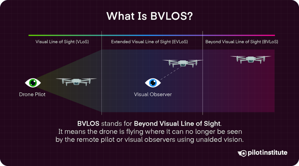
- Visual Line of Sight (VLOS): You (or a visual observer) can see the drone with your eyes the whole time.
- Extended Visual Line of Sight (EVLOS): A team of visual observers (VOs) works to keep sight of a drone beyond normal VLOS limitations, allowing for longer distances.
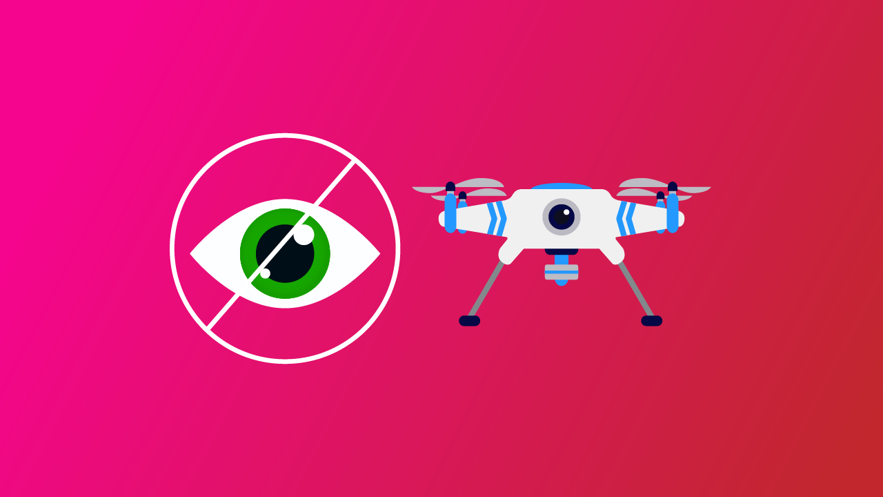
- Beyond Visual Line of Sight (BVLOS): The drone can no longer be seen by human eyes alone, whether that is because the drone is too far or blocked by obstacles. You rely on systems and procedures instead.
Why VLOS Limits Matter
VLOS operations are typically limited to 400 ft AGL to keep small UAS out of manned aircraft traffic zones. It is also difficult to see small UAS at higher altitudes thanks to sunlight glare and reduced contrast against the sky.
Even in optimal conditions, a pilot’s ability to see a drone drops significantly at just 1,500 feet. Risk also increases with distance, with higher chances of signal loss and reduced ability to manage emergencies.
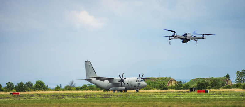
The Leap To BVLOS
Examples of common BVLOS flights include drone delivery services, long-range inspections of power lines or other utilities, search and rescue operations, and mapping large areas.
BVLOS offers a major productivity boost. Automated BVLOS operations have been seen to increase route efficiency, continuity, and accuracy, even over extended distances.
Construction firm Datumate reported that BVLOS drone operations saved firms 40-60% of survey costs and collected data 70% faster than VLOS operations, all while significantly reducing inspection-related safety incidents. Another study published in Results in Engineering confirmed reduced inspection costs around 70% in wind turbine applications.
BVLOS Technology Stack
Still, it is important to take steps when choosing equipment and building operational strategies to maximize productivity while mitigating potentially costly risks.
Command & Control (C2) Links
| Radio Frequencies (RF) | Cellular | SATCOM | |
| Connection Type | 2.4 GHz to 5 GHz frequencies | LTE or 5G | Satellite Connection (ex. GPS, Iridium Satellite Communications) |
| Pros | 2.4 GHz offers greater range.5 GHz has incredibly low latency, often below 10 ms.RF systems are more cost-effective, without monthly service fees. | LTE signals feature mid-range latency, between 10 and 20 ms. 5G signal offers much lower latency, often below 10 ms.Low hardware costs compared to SATCOM. | Much more effective in remote areas, as satellite signal does not depend on cell tower availability.Terrain does not affect signal, like in RF. |
| Cons | 2.4 GHz is limited by slower speeds.In urban areas, 2.4 GHz can also experience congestion, leading to signal interference.5 GHz is limited by physical range.RF signals can break down in rugged terrain within a few dozen miles. | Poor signal in remote areas.Recurring costs in the form of monthly data service plans. | Significantly higher latency, sometimes as high as 500 ms.Bulky and expensive hardware. |
| Drones | Most drones use RF to some capacity, including top DJI and Autel models. | Skydio X10 used for public safety and infrastructure applications. | Large cargo drones like Pipistrel’s Nuuva V300. |
Dual-Link Redundancy
Dual-link redundancy uses two independent command-and-control (C2) links. If one link fails, the other is there to ensure the signal is not lost completely.
Often, drones built for BVLOS applications will include both an RF (900 MHz or 2.4 GHz) and an LTE / 5G cellular link.
To protect against signal loss while on a job, dual-link redundancy is not only recommended, but it can also be required in some waiver application cases.
Detect-and-Avoid (DAA) Options
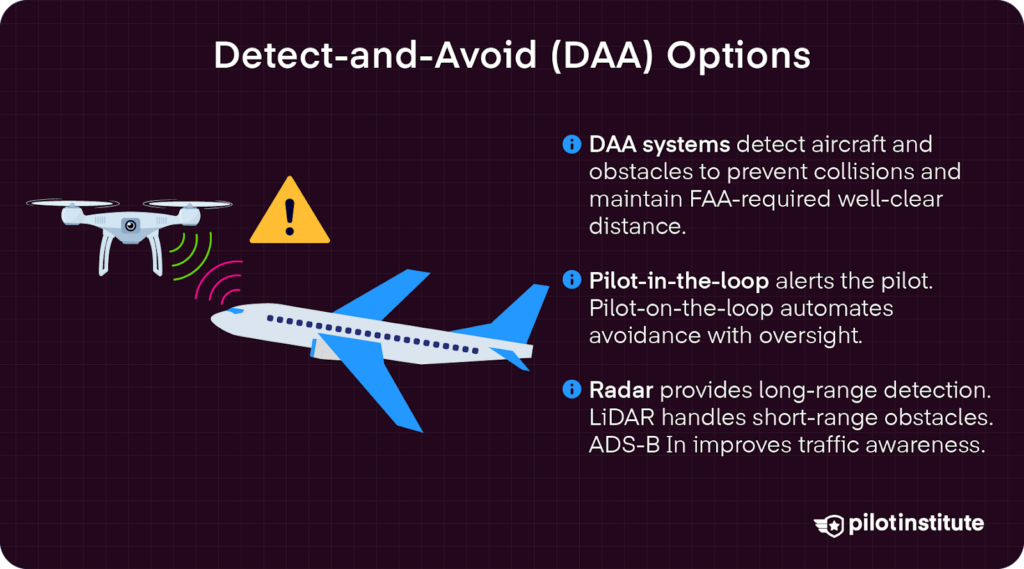
DAA systems, sensors, and procedures allow a small UAS to detect other aircraft or obstacles. Once detected, the drone can take action to avoid a collision.
Pilot-in-the-loop systems alert pilots to act. Meanwhile, pilot-on-the-loop systems feature automatic avoidance, but are still monitored with pilot oversight.
According to the FAA, DAA maneuvers must “ensure a well clear distance has been maintained from other aircraft.” The FAA expects a clearly demonstrated ability to detect cooperative and non-cooperative traffic.
DAA systems detect cooperative aircraft using ADS-B, transponders, or other radio frequencies to transmit locations. They must also be able to detect non-cooperative air traffic that does not have any electronic or radio frequency position reporting systems.
Table Radar
- Detect cooperative and non-cooperative aircraft, signaling this information to drones in flight.
- Works well even in conditions with low visibility.
- DeTect’s HARRIER Beyond Visual Line of Sight (BVLOS) provides long-range airspace monitoring and risk advisories.
- However, such systems are often bulky and expensive, making them hard to manage in field situations requiring constant mobilization.
Optical Radar (LiDAR)
- Laser pulses measure distance to the ground or objects, producing real-time 3D models for quick avoidance reactions.
- Sensors mounted on the drone, reducing size and cost of hardware.
- Yet, LiDAR systems focus on more short-range detection, and thus do not typically satisfy DAA requirements alone.
ADS-B In
- Allows a drone to receive location broadcasts from nearby aircraft that are transmitting their locations via ADS-B Out, which transmits GPS, altitude, velocity, and ID.
- ADS-B In receivers help drones spot nearby aircraft. Early traffic awareness is key to the safest operations, especially in more densely populated areas.
- Easily integrated into the FAA’s Unmanned Aircraft System Traffic Management (UTM).
Navigation & Autonomy
RTK/PPK Systems
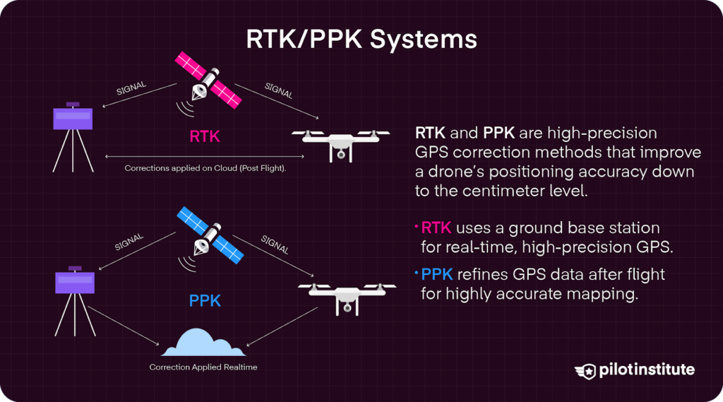
- Real-Time Kinematic positioning (RTK) uses a base station fixed on the ground combined with satellite GPS information for impressively accurate positioning.
- Base stations like DJI’s Dock 2 offer an automated drone-in-a-box system that automates highly precise navigation. Multiple units can be combined to build an automated long-distance BVLOS network.
- Post-Processed Kinematic (PPK) navigation logs GPS data and exact timestamps during flight to later be corrected using ground-based reference stations.
- PPK systems offer more precise geolocation data, great for surveying or inspecting in remote areas.
- However, PPK processes data after the fact, which can impact in-flight safety.
Terrain Relative Navigation (TRN) & Geofencing
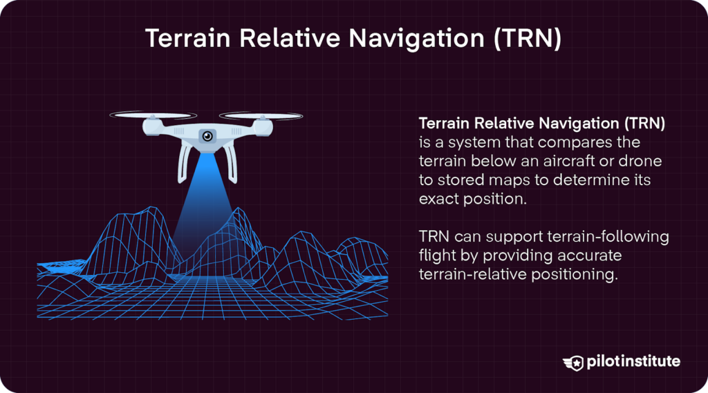
- TRN maintain a safe altitude by tracking the terrain, adjusting themselves to stay at a safe altitude.
- Geofencing imposes flight limits that physically restrict small UAS from entering sensitive or restricted airspace.
Autonomy
- Autonomy allows drones to make split-second safety and navigation decisions.
- RTL+, or Return-to-Launch +, is an enhanced version of RTL that can take advantage of multiple recovery options, terrain-aware routing even in emergencies, and health-based decision making that accounts for factors like battery, GNSS, and wind.
Remote ID & U-space / UTM Integration
According to Part 89, drones must broadcast their Remote ID, essentially functioning like a digital license plate for small UAS. In the new Part 108 being proposed, drones flying BVLOS operations would still need to broadcast their Remote ID and location.
The FAA’s evolving Unmanned Aircraft System Traffic Management (UTM) is a framework “built on regulatory requirements, technical capabilities, and interoperable services to manage and mitigate risks associated with drone operations.” It will combine ADS-B Out data with Remote ID data to safely manage a diverse flight environment composed of manned and unmanned aircraft.
In the EU, the EASA network ID is very similar to the Remote ID in the US, showing the operator registration, unique serial number of the drone, the GPS data, and the route course.
U-space service providers are essential for automating communications and interactions within the rapidly changing small UAS ecosystem. Companies like ANRA Technologies work to help integrate automated flight operations with traditional aviation.
Ground Infrastructure
Drone-in-a-Box systems (DiaBs) are automated, self-contained units that deploys drones, assigns mission details, and recharges batteries, all without the need for human hands.
Yes, (DiaB) systems require high upfront costs, with DJI’s latest Dock 3 priced at over $26,000. However, that one-time cost can pale in comparison to the cost of field crews.
These all-in-one DiaB systems can also greatly reduce inspection times, enhance safety monitoring, and provide faster data for use in critical decision-making on the fly.
DiaB drones provide key leverage for first responders, as drones are able to be automatically launched and controlled to get to disaster relief needs fast.
Elevated antennas can also boost BVLOS performance. They extend RF range to overcome environmental obstacles and the Earth’s natural curvature. This empowers drones with more situational awareness and stronger data links between small UAS and the controller.
Minimum BVLOS Checklist
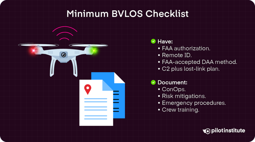
What to Have
Here are some of the things you will need to have.
- Remote ID.
- ADS-B In.
- Anti-collision strobe lights.
- Dual C2 connection strategy.
- Health-monitor API that provides real-time monitoring of drones in flight.
- Parachute Recovery Systems (PRS) that automatically deploy parachutes when a drone malfunctions midair. Some BVLOS applications over people will mandate PRS systems, with options like AVSS’s compliant PRS models for top DJI drones.
- Firmware updates Over-the-Air (OTA) are delivered and installed wirelessly, facilitated with cloud platforms like Elsight’s AllSight or multi-link connectivity strategies that combine 4G / 5G cellular with RF and SATCOM links.
What to Document
You will have certain items you will need to document.
- ConOps.
- Crew roles and responsibilities.
- Training and currency records.
- Safety protocols.
- Flight logs and telemetry.
- Insurance coverage.
- Cybersecurity penetration testing results that expose potential vulnerabilities in communication links, like GPS, Wi-Fi, and cellular links. The FAA recommends the BFDI-AP system that prevents “brute force attacks through first identifying default settings and then executing automated scripts to randomize, thus securing, the identified settings.”
- C2 link performance and any lost-link incidents.
- UTM interactions.
Evaluating BVLOS-Ready Drones
Endurance
How long a small UAS can stay in the air is key for logistics, long-range surveying, inspection, and rescue applications.
Drones with top-level endurance include SiFly’s Q12 Autonomous VTOL drone, boasting 180 minutes of flight time and up to a 90-mile range. Combined with 5G connectivity and an IP55 rating, the Q12 is an excellent rugged option.
Range
Range is another key factor, determining how far BVLOS drones can fly from their control base. Thales’ UAS100 is a long-range fixed-wing BVLOS option that uses hybrid propulsion (internal combustion plus electric motors) for an impressive range up to 124 miles (200 km).
Payload
Payload refers to the capacity to carry objects, including additional cameras, sensors, or even packages for delivery. DJI’s FlyCart 30 is a heavy lifter, able to carry around 88 lbs (40 kg).
DAA-Native
DAA-native models feature built-in DAA and autonomy capabilities, ensuring safe flying in crowded airspace. DJI’s Dock 2 and newest Dock 3 offer impressive automatic sensing that reduces the need for ground crews.
Total Cost of BVLOS Ownership
The total cost of a BVLOS operation extends well beyond the aircraft itself, accounting for the full operational ecosystem.
One of the highest upfront costs is a dock system, with DJI’s newest Dock 3 racking in over $26,000. While expensive, docks cut long-term costs like labor.
Complex sensors like LiDAR, radar, and ADS-B can also add additional upfront costs. Not all drones will be equipped with the minimum standards for BVLOS flight, so expect to spend a bit more on additional sensors if needed.
Data plans are recurring costs needed to keep your fleet connected. SATCOM data plans tend to be pricier than cellular plans, but offer more coverage. Working with service providers when scaling can secure discounts as well.
If you’re completely lost in this whole process, you can hire experts for waiver consulting to develop the necessary ConOps, risk assessment, and safety case documents for your waiver application. Costs can be upfront or monthly. An example is Iris Automation’s Waiver Resource Center, starting at $350 a month. More complex applications could be significantly higher, with some clocking in at $10,000 or higher.
Global Regulatory Snapshot
| Region | Governing Rule | Typical Approval Path | BVLOS Maturity |
| U.S. | Part 107 Waiver / Part 91 COA(Part 108 Pending) | 7711-2 + Safety Case | Medium |
| Canada | Special Flight Operations Certificate (SFOC) + SORA tiers | TC portal | High |
| EU | EASA Specific Category + SORA | NAA operational auth. | Medium |
| UK | CAA SORA OA | CAP 1827 | Medium |
| Australia | CASR Part 101 BVLOS | SORA or Std. Scenario | Medium |
BVLOS Approval Pathway (U.S. Lens)
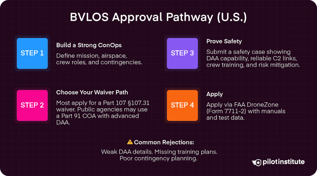
According to 14 CFR §107.31, drones must be tracked by sight to know the distance, altitude, and direction to ensure safe flight that “does not endanger the life or property of another.”
To fly beyond visual sight, you must apply for a waiver. This requires showing proof of additional safety measures, including robust detect-and-avoid (DAA) systems, as well as proven communication and contingency procedures.
Applying for waivers can get confusing and costly, so let’s break down the process.
Step 1: Craft A Bulletproof ConOps
A good Concept of Operations (ConOps) will have a clear mission objective. It defines airspace class and operation environment and outlines human oversight roles.
ConOps also include contingency planning, such as lost-link procedures and emergency ditch sites.
Step 2: Pick Your Waiver Model
Several Part 107 provisions can be waived to allow for BVLOS operations. The most common waivers opt out of provisions in 14 CFR §107.31, which requires the pilot in charge or visual observers to keep the drone in sight.
Unassisted BVLOS
- Does not require a visual observer to maintain constant sight of the small UAS, like in VO-assisted (EVLOS). BVLOS requires the use of anti-collision lights, geofencing, and pre-planned routes.
- Often used in complex operations, including drone delivery systems or light shows. Public Safety Organizations (PSO) can seek waivers for BVLOS in shielded operations.
- Part 107 pilots can apply for waivers to 14 CFR §107.31, §107.39, and §107.145. This allows for BVLOS operations under 200 feet AGL to minimize potential contact with other aircraft.
DAA-Based / Part 91 COA
- A Part 91 Certification of Authorization (COA) allows governmental entities conducting public aircraft operations to fly under 14 CFR Part 91 rules, instead of Part 107. This changes right-of-way rules, minimum safe altitudes, see-and-avoid responsibilities, and operational standards.
- Heightened DAA systems are needed for a Part 91 COA approval.
- Such waivers come with a Higher Specific Assurance and Integrity Level (SAIL), meaning these are considered higher risk because of longer ranges and more complex airspace.
Step 3: Build The Safety Case with SORA
Hopeful BVLOS operators need to submit a Waiver Safety Explanation. The FAA lists specific questions that will need to be answered based on the unique operation and the protocols being waived.
Safety cases should also include maintenance logs for all UAS included in operations and a crew currency matrix.
Using SORA as a Model
The Specific Operations Risk Assessment (SORA) model provides 10 steps that describe the operation in relation to ground and air risks involved. While it is currently used primarily by the European Union Aviation Safety Agency (EASA), the FAA is moving toward a similar approach.
In steps two and three of SORA, you estimate the operations Ground Risk Class (GRC), typically scored from 1-7. This assessment metric evaluates the unmitigated risk of a UAS crashing into the ground, harming people or property. Mitigations like a PRS system and the use of geofencing can help reduce this score.
Next, steps three through five outline air risks and detail strategic and tactical mitigation for those risks, computing the Quantitative Air Risk Class (ARC). The Initial ARC assessment looks at airspace environments (class, density, urban/rural). This is measured from ARC-a as the lowest risk to ARC-d as the highest risk category.
You can reduce the ARC score by reducing risks, such as mitigations like using UTM (USA) or U-Space services (EU), or using DAA-native systems.
Combining the ground and air risk values in step seven produces a Specific Assurance Integrity Level (SAIL), rated from I (low risk) to VI (high risk).
Operational Safety Objectives (OSOs) are determined in step eight based on the SAIL rating. These include key safety procedures, including crew training, maintenance, and minimum technical standards.
Adjacent area and containment requirements are outlined in step nine.
Step 4: Submit Package
Form 7711-2 is the FAA’s Certificate of Waiver or Authorization Application that is currently required for BVLOS flights. Remember, this is likely to change with the implementation of Part 108.
Make sure to include all OEM manuals or third-party documents like spec sheets or data-link certifications from companies like Elistair, training syllabi for crews, and any test data compiled in proof of concept testing.
There are some pitfalls to watch for in the FAA portal, including limited file sizes and missing initials that can halt an application.
Top Rejection Reasons
A majority of waivers are not approved. Top rejection reasons include vague DAA performance details, no crew recurrent training plan, or missing contingency routing maps, so make sure these are included.
If you are lost in the process, remember there are always options for waiver consulting to ensure your application is approved.
Mission Planning & Operational Best Practices
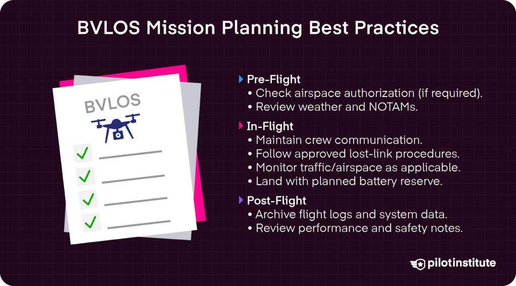
Pre-Flight
File any LAANC requests using apps like Aloft’s LAANC authorization and have approval documentation on hand.
Check the weather with Meteorological Aerodrome Reports (METAR) and more localized regional forecasts with Terminal Area Forecasts (TAF).
Conduct a Notice to Airmen (NOTAM) and Notice to Mariners (NOTMAR) scan in the area of your operations to identify any temporary airspace restrictions, hazards, or maritime activities that could affect flight safety or require operational adjustments before launch.
In-Flight
During flights, maintain continuous communication with visual observers and the pilot in command. You can make this easier by using established brevity codes to ensure rapid traffic and hazard reporting.
Some examples include TALLY for target seen or STRANGER for unidentified traffic that is not participating in the operations.
Actively monitor the lost-link timer to ensure that the aircraft is behaving as expected. Be prepared to execute a dynamic reroute via UTM if prompted by air traffic control, airspace changes, or contingency procedures.
Plan on flying until a 20% battery reserve, meaning using a maximum of 80% of your drone’s battery life.
Post-Flight
Automate log-uploads for compliance and monitoring. Take a snapshot of the ADS-B track at key phases (launch, reroute, and recovery) to preserve a time-stamped record of cooperative traffic and airspace conditions for post-flight review, incident investigation, and regulatory compliance.
Safety Management System Integration
Additionally, a Safety Management System (SMS) debrief helps solidify lessons learned in-flight for future operations.
Top key performance indicators (KPIs) for review include lost-link incident rates, reported maintenance issues (mx squawks), and waiver deviations that document unplanned departures from specific requirements of operational flight.
Part 108 (What’s Changing and What to Do Now)
The FAA published a Notice of Proposed Rulemaking (NPRM) in August 2025, carving out the basic structure of Part 108 to scale BVLOS operations, streamlining autonomous drone operations with minimal human supervision. This will significantly reduce the hassle of juggling multiple waivers for larger, more complex missions.
Additionally, in the proposed Shielded Ops (§108.205), the small UAS stays within “50 feet of certain infrastructure, to include power lines and substations, railroads, bridges, and pipelines, when permission from the facility or infrastructure owner is obtained.”
This smaller range, or “shield,” allows for increased safety management practices that reduce risks associated with BVLOS flights and other manned aircraft. In such shielded areas, UAVs would have the right-of-way over manned aircraft.
Conclusion
Approval for BVLOS flight today is structured on the triad of technology, paperwork, and disciplined operations. Skimp on any of these, and the mission’s risk of failure increases exponentially.
Now that you have a solid foundation in what it takes to get BVLOS approval, it’s time to take the necessary next steps.
Get moving on certifications, securing TRUST or Part 107 certs. Stay on top of evolving Part 108 updates and be ready for its implementation.
The future is at our doorstep. Early BVLOS adopters will own tomorrow’s aerial economy. Start building your safety case today and be ready to navigate the approval process with confidence.