
-
Cumulonimbus Clouds: What Are They?
-
What are the Characteristics of Cumulonimbus Clouds? How to Identify Them
- How Cumulonimbus Clouds Form - The 3 Stages of Cumulonimbus Clouds
-
How Tall Can Cumulonimbus Clouds Get?
-
In What Conditions Do Cumulonimbus Clouds Occur?
- Moisture
- Unstable Air
- A 'Trigger'
-
Flying and Cumulonimbus Clouds - 9 Things You Need to Know
- 1) Cumulonimbus Clouds Have Many Different Names in Aviation
- 2) Cumulonimbus Clouds Cause Windshear
- 3) Hailstones Can Be Extremely Dangerous in CBs
- 4) The Air Currents in Cumulonimbus Clouds Can Exceed the Performance of Your Aircraft!
- 5) Cumulonimbus Clouds Are Associated with Severe Turbulence
- 6) Icing, Both Engine, and Airframe Is a Danger in Cumulonimbus Clouds
- 7) Cumulonimbus Clouds Are Packed with Energy
- 8) Cumulonimbus Clouds Are Not Always Obvious
- 9) Never Fly Above A 'CB'
-
Conclusion
While they may look stunning from the ground, there are certain clouds that you will definitely want to avoid when flying. Cumulonimbus clouds come with a range of hazards to aviation. Today we will look at how you can identify cumulonimbus clouds, the risk that accompanies them, and the conditions in which you can expect to see them.
Cumulonimbus clouds are convective clouds that can grow extensively. They are most commonly accompanied by thunderstorms, strong gusts, turbulence, hail, and lightning. Cumulonimbus clouds represent a hazard to aviators for all of these reasons. It is recommended to avoid them by a large margin.
Just what makes cumulonimbus clouds so dangerous? What do they look like, and how can we plan our flight to avoid bad weather?
Well, read on, as you are about to find out…
Cumulonimbus Clouds: What Are They?
Cumulonimbus clouds are what most people would commonly associate with ‘thunderheads’. These clouds are huge in size and invariably bring bad weather. This includes strong winds, heavy rain or hail, and thunder and lightning.
The name of the cloud also points to the above characteristics. When broken into parts, the name ‘cumulonimbus’ tells its own story.
‘Cumulus’ means ‘heaped’, and ‘nimbus’ means ‘rain-bearing’ in Latin.
So, in short, a rain-bearing heaped cloud.
But.
There is much more to the story than that, and the name really doesn’t do cumulonimbus clouds justice. They are a real force of nature and not something you want to fly in or anywhere near.
Here’s what you need to know…
What are the Characteristics of Cumulonimbus Clouds? How to Identify Them
Luckily for us pilots, cumulonimbus clouds are pretty distinctive and easily identified (in most cases, we’ll discuss embedded cumulonimbus clouds later). They have several easy to spot characteristics that make them stand out: –
- A billowing ‘fluffy’ appearance – Most people would describe cumuliform clouds as having a ‘cotton ball’ or ‘cauliflower’ appearance. This is normally a sign of an unstable air mass, which is the perfect condition for cumulonimbus clouds to form
- Extensive height – Cumulonimbus clouds are packed with energy. This energy ensures that they can grow to colossal heights (as high as 52,000ft!)
- Cumulonimbus clouds are associated with heavy rain, a dark grey or even black hue. – This is because they are moisture-laden. The greater the moisture content of a cloud, the darker its color. A cumulus cloud of around 1 cubic kilometer can hold around 1.1million pounds of water!
- An ‘Anvil’ Head – While this feature is normally common in the latter stages of a cumulonimbus’s development, it is a surefire sign that you are dealing with a thunderstorm. The ‘anvil’ or ‘peak’ of a cumulonimbus comes when it grows so extensively that it reaches the tropopause. In this area, the atmospheric conditions are relatively stable.
- Thunder and Lightning – A lot is going on inside cumulonimbus clouds, with air currents rising and falling at great speeds. The precipitation inside the cloud has differing charges as it rises and falls, leading to huge electrical sparks, also known as ‘lightning’.
A cloud may not tick all of the above boxes but can still be classed as a cumulonimbus.
Why?
Well, cumulonimbus clouds have a well-documented life cycle, and their appearance changes depending on what stage you encounter them.
Here are the three stages of cumulonimbus clouds in a quick and easy guide.
How Cumulonimbus Clouds Form – The 3 Stages of Cumulonimbus Clouds
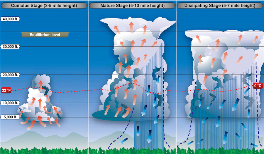
Before we begin, it is important to understand a couple of important concepts. We’ll begin our explanation by imagining a ‘packet’ of air. This forms the ‘seed’ of our cumulonimbus. This air packet must contain moisture for a cumulonimbus to form.
With both of the above concepts in mind, here is the life cycle of cumulonimbus clouds and how they occur.
1) The Initial Stage of Cumulonimbus Clouds: (Cumulus congestus)
At this stage, the cumulonimbus is little more than a large cumulus. A trigger (which we’ll discuss later) causes our moist ‘air packet’ to rise. This is called convection. Updrafts within the cloud cause it to continue rising, often at an exponential rate.
When a packet of air containing moisture cools, it condenses. The moisture is visible when it cools past something called the ‘dew point’. This is how clouds are formed.
Because the air is rising, it will cool slightly, forming clouds…
However, suppose the air in our ‘packet’ is still warmer than the ambient air around it. In that case, our packet will continue to rise, condensing further. The greater the upward ‘push’, the greater the difference between the temperature in our packet and the ambient air around it.
As a result, our packet can begin to rise and condense extremely quickly. Official figures report that this can occur as fast as 30 meters per second. To put it in aviation terms, around 6000 feet per minute!
During the initial stage, most of the development and airflow in the cloud go vertically up.
Such is the extent of this growth that the moisture can be thrust up into the upper atmosphere into temperatures well below freezing. When our air packet reaches these levels, it begins to form ice crystals.
When it reaches this level, it enters the mature stage.
2) The Mature Stage of Cumulonimbus Clouds: (Cumulonimbus Calvus)
Once the moisture condenses, it turns to ice crystals. The convection and rising stop. The upper layers of the cloud are made almost entirely of supercooled water droplets and ice crystals.
The ice crystals will combine with supercooled water droplets to form precipitation (normally hailstones) that begins to fall back down through the cloud.
As we saw earlier, cumulonimbus clouds hold vast quantities of water. The downward force of this falling precipitation generates two things: –
- Downdraughts
- An electrical charge
Both of which are extremely hazardous to aircraft.
When the differences in electrical charges reach a certain level, huge lightning sparks will be apparent, both within the cloud and beneath it.
At this point, the cloud is fully mature.
3) The Dissipating Stage (Cumulonimbus Capillatus)
Obviously, thunderstorms don’t last forever.
At a certain point, the cumulonimbus loses a large portion of its moisture as the precipitation falls back to earth. The downdraughts generated by the heavy precipitation begin to dampen any upward activity before suppressing it completely.
The areas of the cloud that have continued rising eventually reach the tropopause. This cloud portion spreads and forms the peak or ‘anvil’. This portion of the cloud can have a huge diameter. Eventually, this peak will be all that is left of the cloud as the precipitation wanes, and the cloud dissipates.
How Tall Can Cumulonimbus Clouds Get?
Cumulonimbus clouds can climb up to staggering heights. In certain cases, they can grow so extensively that they reach the upper areas of our atmosphere to an area called the tropopause.
Wait, what’s the ‘tropopause’?
In basic terms, tropopause marks the boundary between the troposphere and the stratosphere.
Most weather occurs within the tropopause. This is predominantly down to the fact that there is a relatively linear loss of temperature with a gain in altitude (around 2°C per 1000 feet).
Above the tropopause, the temperature stays relatively constant in the stratosphere, regardless of how high you go. (it sits at around -56°C).
You need to know something important about the tropopause relating to cumulonimbus clouds and thunderstorms…
The height of the tropopause changes based on your location.
Here’s a good general rule of thumb: –
- At latitudes nearer the equator, the tropopause is higher
- At latitudes nearer the poles, the tropopause is lower
Why is this important?
Well, for two reasons.
First, if flying in higher latitudes, you may encounter smaller cumulonimbus clouds that you could, in theory, fly over…
That would be a bad idea. See our below guide to find out why. Second, in warmer, more tropical regions like Florida, Cumulonimbus clouds can grow to phenomenal heights and are packed with energy. Making them exceptionally dangerous to be anywhere near.
In What Conditions Do Cumulonimbus Clouds Occur?
Cumulonimbus clouds can be found the world over. And they require only three basic things to take place. Generally, they are as follows: –
Moisture
Without moisture in the air, cumulonimbus clouds can’t form. Suppose you are fortunate enough to live in a relatively dry area, such as near a large desert in Nevada or Arizona. In that case, you may find that thunderstorms aren’t so much of a regular occurrence.
In the summer especially, ‘tropical’ climates or areas surrounded by water will see an increased chance of thunderstorm activity.
All that said, meteorology and climatology take place on a huge scale. Sometimes moist air can travel for thousands of miles. We call this phenomenon an ‘air mass’.
Sources of moisture could include: –
- The sea
- Large lakes
- Large rivers
- Lush vegetation forested areas
Air masses from other areas
Unstable Air
The second thing we need to consider when discussing cumulonimbus clouds is the stability of the air.
In truth, we should say the relative stability of the air.
Why?
Because air stability, when discussing cumulonimbus clouds, is a dynamic term.
The simplified version?
Remember our ‘air packet’ that we talked about above? When we talk about ‘unstable air’, we do so relatively to this air packet. If we were able to see the air packet and we release it into the atmosphere, we would observe one of two behaviors: –
- If the air packet rises and continues rising, the air is unstable. This is because, at any level, the temperature of the air packet is always warmer, relatively, than the air surrounding it.
It is important to note that the air itself, either our packet of air or the air surrounding it, doesn’t have to be particularly warm or cold. It is about the difference between the two.
- If the air packet doesn’t rise or rise and then stops – The air is said to be stable. This is because the difference between our ‘packet’ and the ambient air eventually reaches equilibrium.
You’ll tend to find that the air is inherently unstable when the air pressure is low. When the air pressure is high, the air will be stable (which is why you get that crystal clear and cloudless days with higher pressures).
A ‘Trigger’
So, we have two out of the three covered.
What’s next?
Well, the final piece of the puzzle is something that gives our air packet a little ‘push’ in the right direction, i.e., upward.
And it doesn’t take much…
Numerous’ triggers’ can cause an air packet to begin rising and start to form a cumulonimbus. This includes: –
A Warm Landmass
Large land areas can heat relatively quickly from the sun’s rays, holding a surprising amount of energy. All it takes is a large packet of moist air to drift over! From there, it will start to rise and form a convective cloud.
Coastal Lifting
Like the above, coastal areas can provide the ideal setting for cumuliform clouds. The air of the sea is laden with moisture due to evaporation. This air can be brought over warmer land with an oncoming sea breeze, lifting and condensing.
Orographic Lifting
Sometimes the land doesn’t even have to be warm. You will often notice clouds forming around hills, mountains, and ridges. This is because traveling air hits the slopes and is forced to travel upward. Cooling and condensing in the process.
Converging Airmasses
Air masses are huge bodies that exist on a continental level. There is a boundary between them, and warmer air can be forced over cooler air, leading to thunderstorms in the areas where they meet.
Frontal Activity
On a smaller, more localized level, frontal activity can lead to the formation of cumulonimbus clouds. Fronts are traveling areas of high and low pressure that influence the weather daily. You may actually be able to see the boundaries of these fronts in a squall line.
Wildfires
Large wildfires release lots of energy into the atmosphere. It is often the case that the heat caused by wildfires is enough to trigger instability and a rising air packet, creating a thunderstorm.
Man-Made Activity
While thunderstorms and cumulonimbus clouds are, more often than not, a natural occurrence, occasionally, man-made actions can produce a trigger effect. Large power station cooling towers release hot, moisture-laden air. Occasionally on very cold days, you’ll be able to see cumulous clouds forming over chimneys and cooling towers.
Flying and Cumulonimbus Clouds – 9 Things You Need to Know
Why is the above information about cumulonimbus clouds so important?
In basic terms, they are really dangerous to airplanes.
Here are 9 essential things you need to know about flying and cumulonimbus clouds.
1) Cumulonimbus Clouds Have Many Different Names in Aviation
While cumulonimbus clouds are dangerous, you’ll rarely hear them referred to by their full name either when flying or planning a flight. Aviators love abbreviations and acronyms. Here are some of the alternative terms that are used in aviation to describe a cumulonimbus: –
- A ‘buildup’
- A ‘cell’
- ‘Weather’
- A ‘CB’
Wait… A ‘CB’? Yes, this is a term taken directly from the meteorological information provided to pilots. You can see a full decode provided by the FAA here.
Think carefully about the implications if you see ‘CB’ anywhere on your weather information or forecast.
2) Cumulonimbus Clouds Cause Windshear
In our guide to the life cycles of a CB above, we talked about how the air eventually begins to sink in downdraughts.
This can be really dangerous when flying.
Even in the prevailing wind is going in a steady direction, a CB can cause it to rapidly change direction.
The bottom line?
A rapid loss of lift! If you are making an approach and are close to the ground, this can have disastrous consequences.
Keep a good eye on the forecast and also the windsock. Downbursts and gusts from thunderstorms can extend many miles ahead of the cloud.
3) Hailstones Can Be Extremely Dangerous in CBs
When we talk about hailstones in cumulonimbus clouds, we aren’t talking about the tiny, pea-sized lumps you might encounter while out on a walk.
These things are huge. Hailstones in cumulonimbus clouds can sink, melt a little and then rise again to become huge. And by huge, we mean softball-sized.
Check this out to see how dangerous hail can be to aviation.
4) The Air Currents in Cumulonimbus Clouds Can Exceed the Performance of Your Aircraft!
As we saw, the air inside a CB can move at an alarming rate. With a rate of climb exceeding 6000 feet per minute, you may find yourself in an uncontrolled climb!
And even worse…
With a severe downburst, you might find yourself in a situation where your aircraft can’t outclimb the sinking air in which you are flying. It isn’t enough to avoid flying in a cumulonimbus in these cases. You will need to avoid flying under one too!
5) Cumulonimbus Clouds Are Associated with Severe Turbulence
A lot is going on inside those billowing white clouds. Air is rising and descending at a phenomenal rate. When air is going in different directions, it creates turbulence.
In certain circumstances, turbulence is something that you really need to be mindful of.
In particular, severe turbulence.
What’s so bad about severe turbulence? Allow us to quote the Federal Aviation Administration: –
“[Severe Turbulence] causes brief periods where effective aircraft control is impossible. It may cause damage to aircraft structures.”
Impossible to control the aircraft?
No, thanks.
6) Icing, Both Engine, and Airframe Is a Danger in Cumulonimbus Clouds
The dangers of icing in aviation are numerous. You’ll have seen lots of talk of supercooled water droplets and ice crystals in our above guide.
Neither of these two phenomena is aviation friendly.
Why?
- Carburetor icing can cause your engine to stop
- Airframe icing can cause your aircraft to stall
7) Cumulonimbus Clouds Are Packed with Energy
It’s just a cloud? It can’t be that bad, right?
Wrong.
When we say cumulonimbus clouds are packed with energy, we mean it.
How much energy?
Well, it is thought that your average CB will contain about as much energy as 10 Hiroshima-sized nuclear bombs!
8) Cumulonimbus Clouds Are Not Always Obvious
This is an important one, so pay attention.
You can only avoid cumulonimbus clouds if you can see them.
Sounds obvious, right?
Well, ‘embedded’ CBs are a particular danger. In certain meteorological conditions, cumulonimbus clouds can exist within other types of clouds, namely stratiform layers. In really basic terms, flat grey clouds form in warm or occluded fronts.
Unless your aircraft has weather radar or you are VFR flying only, this may be a day when it is best to stay on the ground. Keep a good lookout for “EMBD CB” written on forecasts and weather reports
9) Never Fly Above A ‘CB’
There may be a temptation when encountering cumulonimbus clouds, especially during the initial and dissipating stage, to try and ‘sneak’ over the top.
This is a seriously bad idea.
The updraughts during the initial stage are incredibly fast-moving, and they can actually extend well beyond the upper limit of the visible cloud.
On particularly cold days, there may be an invisible ‘spray’ of hailstones and ice particles well above the visible portion of the cloud.
Quite simply put, avoid cumulonimbus clouds completely. Don’t fly next to, over, or under them to ensure complete aircraft safety.
Conclusion
Cumulonimbus clouds are a sight to behold, but the best place to observe them is with your feet firmly planted on the ground. There is little good that can come from flying in the vicinity of CBs, and they are best avoided at all costs. Now you know why they occur, where they occur, and some great airmanship points for avoiding them. Meteorology is an area you will be tested on when completing pilot training. Why not look at some of our flight ground school courses, and become an expert?