-
Key Takeaway
-
What Is Fog?
-
1. Radiation Fog
- How to Identify and Avoid Radiation Fog
-
2. Advection Fog
- How to Identify and Avoid Advection Fog
-
3. Upslope Fog
- How to Identify and Avoid Upslope Fog
-
4. Steam Fog
- How to Identify and Avoid Steam Fog
-
5. Freezing Fog and Ice Fog
- How to Identify and Avoid Freezing Fog
-
6. Frontal Fog
- How to Identify and Avoid Frontal Fog
-
7. Precipitation Fog
- How to Identify and Avoid Precipitation Fog
-
Conclusion
Fog is a significant hazard to pilots flying VFR.
Imagine getting caught in a thick fog that brings your visibility to zero – not good.
How can we avoid this?
By understanding the different types of fog! Understanding how fog forms, moves, and dissipates is key to avoiding getting caught by it.
In this guide, we’ll go through every kind of fog you need to know as a pilot.
Key Takeaway
- Fog forms when air temperature meets the dew point, dropping visibility below ⅝ statute miles.
- Each of the seven fog types differs by what cools the air or adds moisture.
- Radiation fog burns off after sunrise; advection and upslope fog can persist in wind.
- Check weather reports, know your terrain, and be willing to delay or turn back.

Private Pilot
Study Sheet

Grab a printable PDF that highlights must-know PPL topics for the written test and checkride.
- Airspace at-a-glance.
- Key regs & V-speeds.
- Weather quick cues.
- Pattern and radio calls.
What Is Fog?

In a nutshell, fog is a low-lying cloud. Tiny water droplets near the Earth’s surface cause the reduced visibility we call fog.
Fog, like other clouds, hampers visibility and directly impacts flying.
Fog forms when air temperature matches the dew point, causing water vapor to become visible droplets.
There are various types of fog, which form either through increased moisture or decreased temperature.
But what’s the difference between fog and mist?
For pilots, it’s simply down to visibility. If the visibility is greater than ⅝ statute miles, we classify the low-lying cloud as mist. If the visibility is less than ⅝ statute miles, it’s classified as fog.
Haze is also a phenomenon that affects visibility. Small particles like dust or smoke that don’t naturally occur in the air make up haze. Haze doesn’t necessarily form close to the ground like fog or mist.
Meteorologists classify many different types of fog according to how it forms.
In this article, we’ll cover the most important types of fog that you may come across in your aviation journey. You’ll find these seven types in the Pilot’s Handbook of Aeronautical Knowledge (PHAK).
1. Radiation Fog
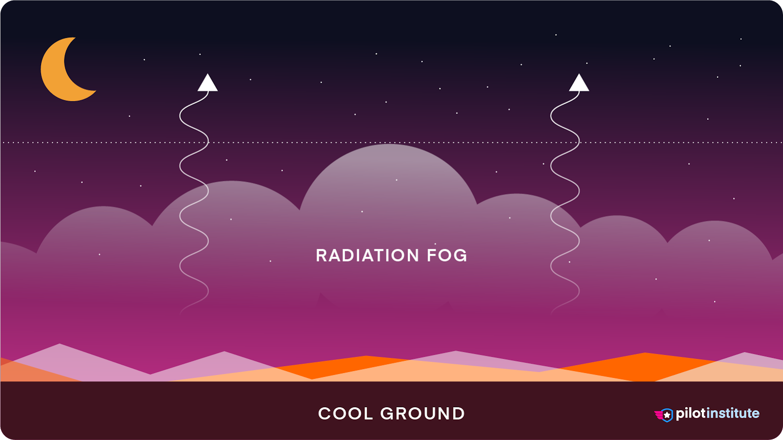
Radiation fog forms at night when the surface cools, causing the air above it to cool as well.
If the air has enough moisture, this cooling will lead to saturation and form fog.
This type of fog is also known as ground fog if it’s less than 20 feet thick.
You’ll often find radiation fog early in the morning when the surface is coldest. It tends to dissipate soon after sunrise as the ground warms. Because of this, many people call radiation fog “morning fog.”
The conditions that lead to the formation of radiation fog are:
- Clear skies (clouds will trap heat).
- Calm winds (allowing uninterrupted cooling of the air).
- Long nights (allowing the longest time for the surface to cool).

High-pressure systems often create the conditions that lead to radiation fog.
How to Identify and Avoid Radiation Fog
Use Weather Reports
We can use weather reports to check if the conditions for radiation fog will be present.
Clear skies, calm winds, and long winter nights are a strong indication that you’ll find radiation fog in the morning.
Identify Susceptible Areas
Some places are more prone to radiation fog than others.
Valleys and low-lying areas are particularly susceptible to radiation fog. Cold, dense air tends to settle in these lower areas. As the air sinks into these areas, it cools and forms fog.

Read up on local weather patterns and talk to local flight instructors to get an idea of how common radiation fog is in a particular area.
Expect Delays
We know that no one likes delays. But if radiation fog is at the airport, you won’t be able to go anywhere soon.
Thankfully, radiation fog will burn off after sunrise. Factor in this time for your planning to keep your flight on schedule.
2. Advection Fog
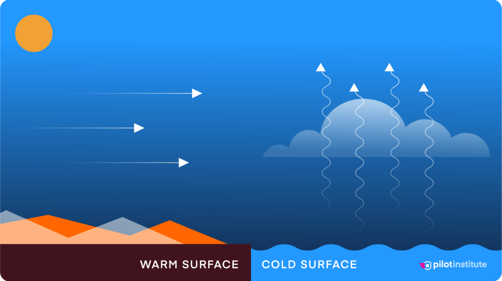
Advection fog forms when warm, moist air moves over cooler ground or water. It is relatively shallow and often associated with an inversion.
Advection fog differs from radiation fog because it may still form when there is strong wind and cloud cover.
How to Identify and Avoid Advection Fog
Beware of Coastal Areas
When operating in and out of airports in coastal areas, beware of the possibility of advection fog.
Check the Wind
Advection fog relies on wind to form, but it also causes it to dissipate.
For advection fog to dissipate, you either need a change in wind direction or speed to move the air mass.
Look at forecasts and identify areas where the wind is blowing in a way that may cause (or dissipate) advection fog.
3. Upslope Fog
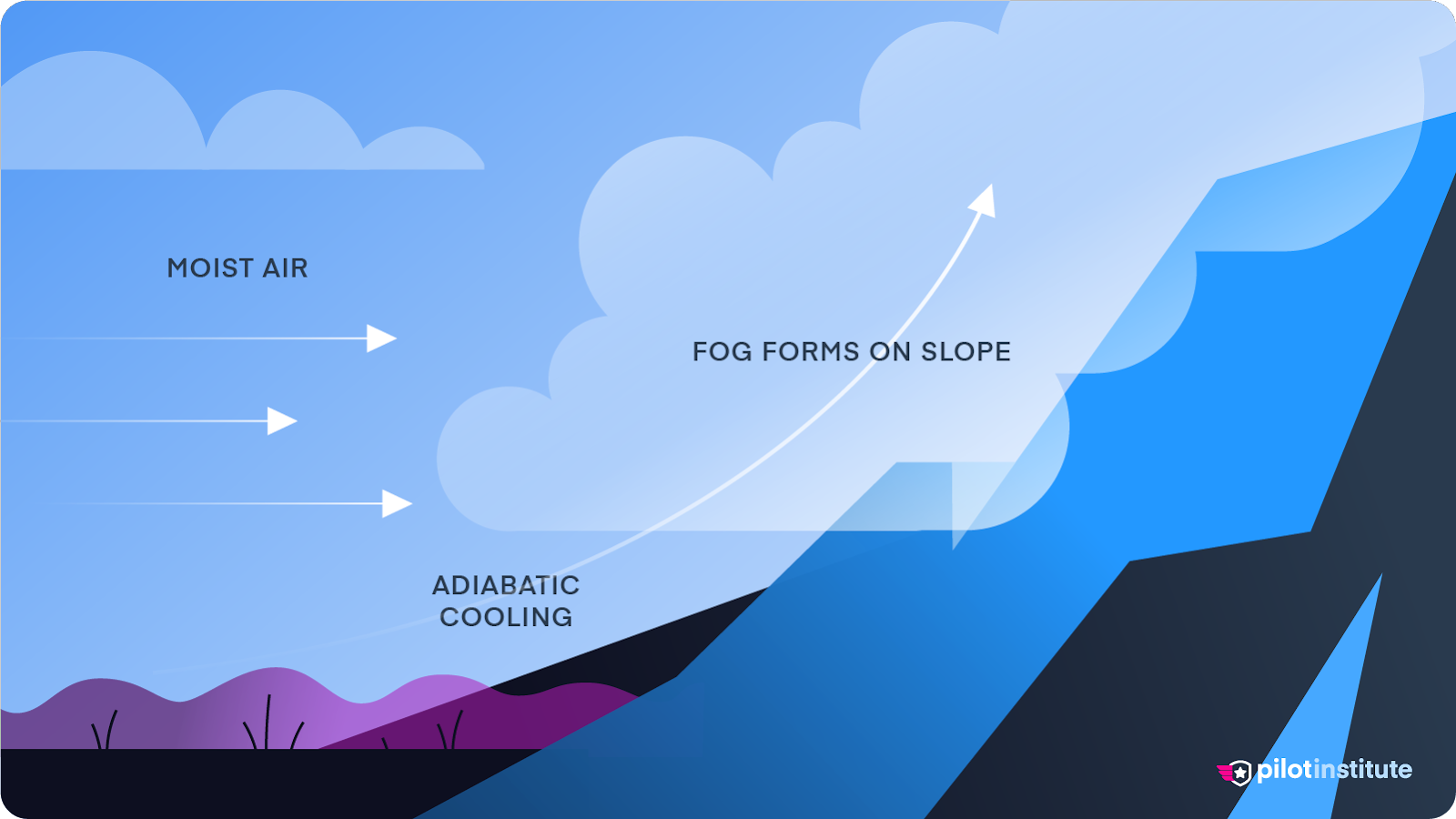
Upslope fog forms when moist air flows upward over rising terrain, causing it to cool adiabatically to its dew point temperature.
“Adiabatic” is a word used to describe the process that causes rising air to cool and sinking air to warm.
This type of fog is prevalent at higher elevations and can build downward into valleys.
Like advection fog, upslope fog can be present at high wind speeds because of the increased lift and adiabatic cooling.
How to Identify and Avoid Upslope Fog
Identify Susceptible Areas
Upslope fog typically forms on the windward sides of hills, mountains, or any elevated terrain.
If you’re in or near such areas, especially during stable weather conditions, be mindful of the potential for upslope fog.
Wind drives moist air up a slope, causing it to cool as it rises, resulting in upslope fog. Pay attention to the wind direction; if it’s moving air up a slope, upslope fog may form.
4. Steam Fog
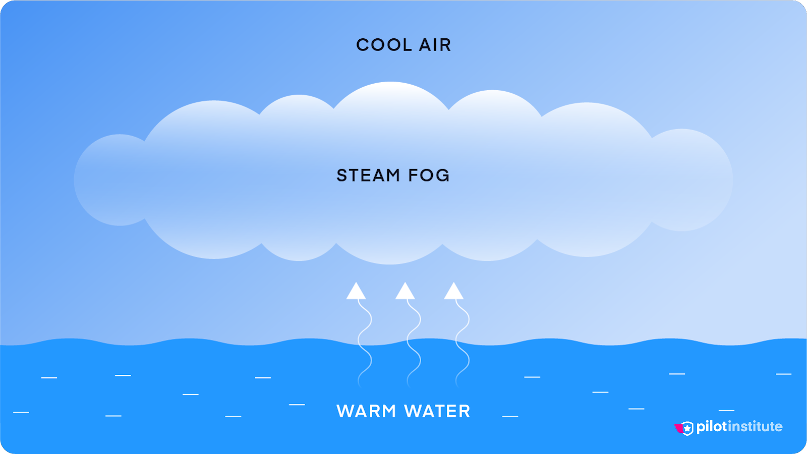
Steam fog, also known as evaporation fog, forms when cold air comes into contact with warm water.
The warmer water evaporates into the cooler air above, increasing the air’s moisture content. When the moist, warm air mixes with the cooler air, the water vapor condenses into tiny water droplets, creating fog.
This often happens in early fall or late spring when the air temperature drops quickly compared to the water temperature.
So, what does steam fog look like?
Steam fog often appears as wispy tendrils rising from the water’s surface, resembling steam, hence the name “steam fog.”
You’ll often find steam fog over bodies of water like lakes, rivers, and reservoirs.
How to Identify and Avoid Steam Fog
Beware of Airports Close to Water
For aerodromes located next to bodies of water, visibility may be an issue when arriving or departing.
Make sure to check the weather forecast and beware of the potential for steam fog, especially during early fall or late spring.
5. Freezing Fog and Ice Fog
Freezing fog forms in saturated air when the surface temperature is below freezing point (0°C or 32°F).
The droplets in freezing fog are supercooled, meaning they are in a liquid state despite being below freezing temperature. They do not freeze in the air because they lack a nucleus or core around which an ice crystal can form.
Freezing fog is more common in regions with cold winters, especially in valleys and areas where cold air pools.
The freezing temperatures cause supercooled water droplets to freeze on impact with a surface. This creates rime ice on the ground or other objects.
It’s important to differentiate freezing fog from ice fog.
Ice fog resembles freezing fog, but it consists of tiny ice crystals and occurs in extremely cold conditions, usually well below 0°C (32°F).
Freezing fog, on the other hand, contains liquid droplets and forms at temperatures around or just below freezing.
How to Identify and Avoid Freezing Fog
Check for Ice
When freezing fog is present, make sure you thoroughly check the airframe for ice.
Keep the Aircraft in a Hangar Overnight
If freezing fog is forecasted overnight at the aerodrome where you plan to park your aircraft, either hangar it or use wing covers to prevent ice.
This will ensure that when you arrive in the morning, you’ll have the best chance of departing on time when the fog has cleared.
6. Frontal Fog

Frontal fog forms during the transition of a warm or cold front. Warmer rain falls into colder air, evaporating and raising the dew point, leading to saturation.
The fog associated with warm fronts is pre-frontal, whereas fog associated with cold fronts is post-frontal.
Frontal fog usually dissipates after the front passes.
How to Identify and Avoid Frontal Fog
Use Weather Reports
Be aware of the frontal systems that may affect your flight, and anticipate the potential for fog.
Turn Around
Since frontal fog occurs during the passage of fronts, if encountered, you can turn back and away from the front.
7. Precipitation Fog
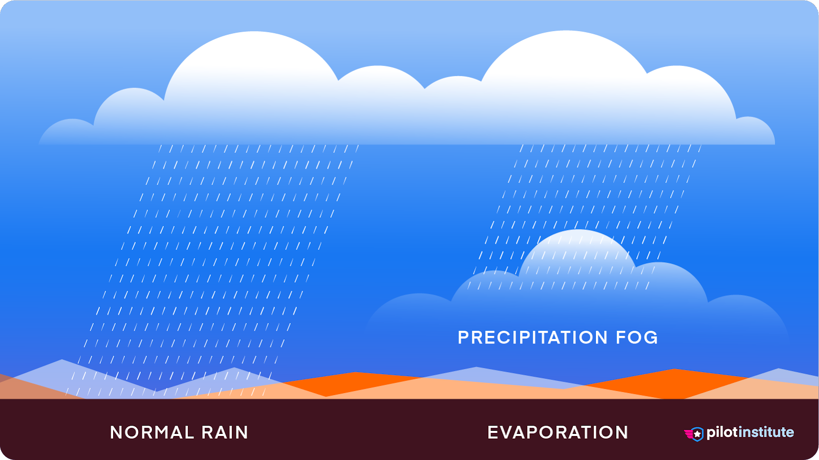
Precipitation fog forms when rain falls through cold and dry air. The increased moisture leads to an increase in the dew point, causing saturation and the formation of fog.
Precipitation fog is associated with warm fronts but can also result from a slower-moving cold front.
How to Identify and Avoid Precipitation Fog
Use Weather Reports
Similar to frontal fog, anticipate frontal areas prone to precipitation fog.
Avoid Precipitation
It is essential to remain in visual conditions while flying VFR.
Not only will the fog decrease your visibility, but the precipitation will as well.
Avoid areas of precipitation, and you’ll avoid precipitation fog, too.
Turn Around if Necessary
Remember, with fog associated with frontal systems, sometimes the safest and clearest route is behind you. So don’t be afraid to turn back.
Conclusion
Fog is a common weather phenomenon we will all encounter during our flying careers.
Understanding the different types of fog and how they form is a crucial skill for any pilot.
If you’re interested in learning more about weather systems and how they impact your flying, read our article on high vs. low-pressure systems.