-
1. According to the weather report, the ceiling for today will be at 700 feet. What is the maximum altitude that you are allowed to fly your drone?
-
2. Determine the standard pressure at 3000 feet MSL using standard lapse rates
-
3. In the quadrant shown in the sectional chart, what is the minimum altitude that you must fly to avoid all the obstacles in the area?
-
4. While looking at a quadrant of a sectional chart, you notice military training routes labeled IR146 and IR147. What do the numbers on the labels indicate?
-
5. What is the upwind direction of Runway 16?
-
6. If you change your mailing address, you are required to update the information under the registration of your drone within:
-
7. You have been commissioned to a do an inspection of a communications tower located around 3 SM NW of the Mason Jewett Airport. Based on the sectional chart below, up to what maximum altitude are you permitted to fly while doing the inspection?
-
8. What is the CTAF for the Mason Jewett Airport?
-
9. The maximum groundspeed allowed for drone flight under Part 107 rules is:
-
10. What is the floor of the Class E airspace surrounding the Garrison Municipal Airport?
-
Final thoughts
The market for drone services has been growing steadily for the last couple of years and is expected to continue to grow well until 2025. With such a thriving demand for drone-based services, the Part 107 drone license has become quite the commodity. Since it was first implemented in 2016, the FAA has now granted hundreds of thousands of drone pilots the privilege of flying their drones for profit.
If you’re still working towards earning your own drone license, then the prospect of taking the knowledge test may seem intimidating. We’re here to help ease your worries a bit. We have compiled a list of the twelve questions that most test-takers have missed and attempt to answer them in the most detailed way possible.
1. According to the weather report, the ceiling for today will be at 700 feet. What is the maximum altitude that you are allowed to fly your drone?
- 200 feet AGL
- 200 feet MSL
- 400 feet AGL
- 700 feet AGL
The correct answer is 200 feet AGL.
In meteorology, the ceiling is defined as the base altitude of the lowest clouds reported relative to the ground. The FAA rules require that drone pilots maintain a buffer distance of 500 feet from the ceiling. This rule supersedes the 400-foot maximum altitude limit for drones in otherwise clear conditions. If the skies are completely clear of clouds, the weather report will describe the ceiling as “unlimited.”
The question also requires an understanding of the difference between above ground level (AGL) and mean sea level (MSL) units of altitude. Since the ceiling is reported in AGL units, the maximum allowable limit for drone flight should also be expressed in AGL.
2. Determine the standard pressure at 3000 feet MSL using standard lapse rates
- 29.92” Hg
- 39.92” Hg
- 26.92” Hg
- 23.92” Hg
To answer this question, you will need to know a few basic values to be used for the computation. First is the standard pressure at sea level, which is 29.92” Hg or 1 atm in metric units. The question is asking for the pressure at 3000 feet elevation. Since we know that pressure drops with increasing altitude, we can already eliminate options A and B.
A standard lapse rate is a tool used to quickly estimate the standard pressure at any elevation. While it doesn’t give accurate values, it’s still a useful tool in estimating atmospheric pressures in the absence of any pressure measurement tool. The standard lapse rate used in several industries including aviation is 1” Hg of pressure per 1000 feet of altitude change.
To solve the question, we simply need to calculate for the pressure drop for 3000 feet of altitude gain, which is 3” Hg. The estimated pressure at 3000 feet would then be 26.92” Hg.
3. In the quadrant shown in the sectional chart, what is the minimum altitude that you must fly to avoid all the obstacles in the area?
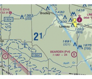
- 2100 feet MSL
- 2100 feet AGL
- 210 feet AGL
- 210 feet MSL
One of the most important details to look for when you’re looking at section charts is the Maximum Elevation Figure (MEF). Each quadrant of a sectional chart is labeled with the MEF in big, bold letters. In our example, the MEF is indicated as a big 2 superscripted by 1.
Answering this question is only a matter of understanding what the figures in sectional charts mean. The ‘21’ indicated as the MEF in our quadrant refers to an elevation 2100 feet.
Again, the question throws another unit-related curveball by mixing up AGL and MSL readings. Although the MEF figure in the sectional chart does not specify if it’s in AGL or MSL, all you need to know is that these readings need to be standardized across different quadrants of the sectional chart. This means that they need to have a common reference point, the most practical one being the altitude at sea level. Thus, the correct answer is 2100 feet in MSL units.
4. While looking at a quadrant of a sectional chart, you notice military training routes labeled IR146 and IR147. What do the numbers on the labels indicate?
- The military training route is below 1500 feet AGL
- The military training route is above 1500 feet AGL
- The numbers indicate the ground speed of the aircraft
- The numbers are randomly assigned
The answer to this question is pretty simple, but this is a good chance to review the codes for military training routes (MTR). In sectional charts, military training routes are represented by arrows with labels that contain start with either an IR or VR prefix. The only difference between the two is that IR routes are flown under air traffic control while VR routes are not. As far as drone pilots are concerned, this distinction is not that relevant.
The more important aspects to consider are the direction of the training route and the numbers following the prefix. Military training routes labeled with four digits fly below an altitude of 1500 feet AGL, while those with three digits fly above the 1500 feet AGL boundary.
For our example, the IR146 and IR147 military training routes are flown above 1500 feet AGL. These should be less of a concern for drone pilots unless you’re flying your drone at exceptionally high altitudes.
However, extra care needs to be exercised if you spot a four-numbered MTR in the quadrant where you are operating your drone. There’s no telling exactly how low military aircraft can fly, and they can zip by at speeds exceeding 250 knots. Even if you were fully aware of your surroundings, you will have a very small window of time to do evasive actions. To avoid running into trouble, it would be best to stay away from this type of MTR completely.
5. What is the upwind direction of Runway 16?
- North-west
- South-east
- East
- North
To answer this question, all you need is a good grasp of angles and directions. The only information you’re given is the designation of the runway – Runway 16. Let’s start with that and deduce our way to the answer.
The number of the runway – in our case, 16 – is indicative of direction to which the runway is directed. For our question, the magnetic azimuth of the Runway 16 is 160°. This is an aviation standard, so all runways follow this rule. The magnetic azimuth of Runway 27 is 270°, and that of Runway 12 is 120°.
A runway is just a long strip of bare road that is open to both sides, so you can imagine how it’s possible for a runway to be approached from opposite sides. However, a distinction needs to be made based on the direction of approach of a plane to a runway. Thus, Runway 16 needs to be approached at an angle of 160°. Approaching it from the other side will require that the runway be referred to as Runway 34. This is so important that runway numbers are described in radio communications by pronouncing each digit of the numbers individually.
The upwind direction of a runway is merely the direction by which it will be approached. For our question, the angle of 160° indicates a south-southeast approach. Out of all the choices available, the southeast answer seems to be the most appropriate.
6. If you change your mailing address, you are required to update the information under the registration of your drone within:
- 7 days
- 10 days
- 14 days
- 30 days
What may seem like a simple question has caused a lot of lost marks to drone pilots because of the jumble of required reporting periods contained in the Part 107 rules. This question is particularly confusing because it pertains to the requirement of the drone registration, not of the Part 107 drone license.
To clarify, the Part 107 rules require that you update your remote pilot certificate information within 30 days of any change in your mailing address. However, the reporting requirements for updating your drone registration information are different. You must update your drone registration information within 14 days of changing your mailing address. Answering this question is really just a matter of reading the question carefully.
As a side note, the 10-day period pertains to the requirement for reporting a drone-related accident to the FAA.
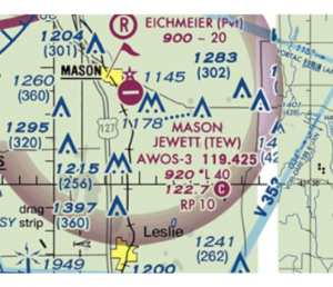
7. You have been commissioned to a do an inspection of a communications tower located around 3 SM NW of the Mason Jewett Airport. Based on the sectional chart below, up to what maximum altitude are you permitted to fly while doing the inspection?
- 301 feet AGL
- 400 feet AGL
- 701 feet AGL
- 1204 feet AGL
The Part 107 rules say the commercial drone flight is only permitted up to an altitude of 400 feet AGL except if you are within 400 feet of a structure. In this case, the tower being inspected qualifies as a structure that will allow you to fly above the 400-foot limit.
The tower indicated in the question is the one directly northwest of the Mason Jewett Airport. It is represented by two altitude figures – 1204 MSL and 301 AGL. This altitude will serve as the reference point from which you can determine how high you can fly your drone.
To determine the new altitude limit when flying in proximity with the tower, you only need to add 400 feet to the tower’s highest point. Since all choices are given in AGL units, the best reference would be the 301-foot figure. Simply add 400 feet to get the final answer – 701 feet AGL.
8. What is the CTAF for the Mason Jewett Airport?

- 119.4
- 119.425
- 122.7
- 122.8
This is another straightforward question on a topic that many drone pilots miss because they weren’t able to understand it fully while studying. The first thing we need to know is what a CTAF is and how it is relevant to the distinction between controlled and uncontrolled airports.
In our example, the symbol for the Mason Jewett airport is colored magenta, indicating that it an airport with no control tower or air traffic control (ATC unit). In the absence of a control tower, pilots passing by the airport are expected to self-announce their position and intentions.
While drone pilots aren’t necessarily required to self-announce when flying near airports, they are still encouraged to listen to the CTAF, or the frequency where self-announcements are broadcasted. This develops enhanced awareness of their surroundings and allows them to anticipate the presence of any manned aircraft.
In sectional charts, the CTAF for each airport is represented by a number next to a “C” symbol bounded by a magenta circle. For our example, the CTAF for the Mason Jewett Airport is 122.7.
9. The maximum groundspeed allowed for drone flight under Part 107 rules is:
- 87 miles per hour
- 87 knots
- 100 knots
- 110 miles per hour
This is an easy question that many test-takers get wrong simply because of misreading it. The Part 107 rules specifically state that the allowable maximum ground speed for a drone is 100 miles per hour. However, this specific figure isn’t in the choices.
Instead, most of the choices are given in the unit of knots. Since a conversion factor needs to apply, we can safely eliminate all but one of the choices to arrive at the correct answer – 87 knots.
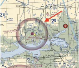
10. What is the floor of the Class E airspace surrounding the Garrison Municipal Airport?
- 700 feet MSL
- 1937 MSL
- 2206 MSL
- 2637 MSL
The Class E airspace surrounding the Garrison Municipal Airport is defined by the thick magenta line surrounding it. Based on the label of the airspace boundary, it has a floor of 700 feet AGL. This would have been a correct answer, if not for the fact that it’s not included in the choices. Since all the choices are given in MSL units, we are going to have to determine the MSL equivalent of the 700 feet AGL altitude.
To convert the units, we need to determine the altitude of the terrain of the airport. Fortunately, this is also provided in the sectional chart – or more specifically, by the symbol representing the airport. According to the magenta symbol of the airport, it sits at a terrain that has an elevation of 1937 feet MSL. If the floor of the Class E airspace sits at 700 feet above the ground, then we simply add the terrain elevation to determine the equivalent MSL altitude, which is 2637 feet MSL.
- While doing a paid drone job, you get distracted and crash your drone into the branches of a tree. Although the drone comes to a soft landing on some bushes, you notice that one arm of the drone has become slightly bent. What is the best course of action at this point?
- Immediately ground the drone
- Send the drone in for repair or replacement of parts
- Follow the drone manufacturer’s recommendation
- Do a test flight at low altitude
At first glance, all the choices presented for this question seem like reasonable options. However, the test isn’t looking for an answer that’s practical – it’s only looking for an answer that is consistent with the Part 107 rules. This means that you’ll have to pick the BEST out of the given choices, even if all the choices seem like reasonable answers.
The Part 107 rules do not specifically dictate what licensed drone pilots should do if their drone suffers any damage. There is also no standard condition that a drone should have before it can be declared to fly. All the FAA requires is that drone pilots perform a pre-flight inspection of their drones. In the case of potential damage, the FAA always defers to the recommendations of the manufacturer.
- While flying your drone near the Cooperstown Airport, you receive a self-announcement from an aircraft which states that it is at aircraft midfield right downwind of Runway 13. What is the position of the aircraft relative to the runway?
- North-East
- North-West
- South-East
- South-West
Again, this question requires that we review the concept of runway orientations. We already know that the magnetic azimuth of Runway 13 is at an orientation of 130°. This means that its upwind direction is facing southeast and its downwind direction is facing northwest.
According to the aircraft’s advisory, it is traveling towards the downwind direction and is positioned to the right of the runway. Although it’s traveling at the downwind direction, the aircraft still refers to the runway as Runway 13, which means that the orientation of the runway is still relevant to determining the aircraft’s position.
If we’re considering the southeast orientation of the runway, its left side corresponds to the northeast position and its right side corresponds to the southwest position. Thus, the aircraft is located southwest of the runway and is traveling at a northwest direction.
Final thoughts
While it’s true that hundreds of thousands of drone pilots have passed the Part 107 knowledge test, that doesn’t mean that you can get sloppy with your preparations. As many aspiring drone pilots have attested to, the questions we’ve listed down here have caused a lot of them to lose marks or to outright fail the knowledge test. This list is a chance for you to learn from their mistakes and improve your chances of passing the knowledge test on your first try.