-
Section 1: Acknowledgement
-
Section 2: Waiver Application
- Select the option for waiver application for Daylight operations
- Description of proposed operation:
- Describe how the RPIC will maintain visual line of sight
- Describe how the RPIC will see and avoid other aircraft, people on the ground, and ground-based structures and obstacles during darkness
- Describe how the RPIC will be able to continuously know and determine the position, altitude, attitude, and movement of the SUA
- What procedures will be followed to ensure all required persons participating in the operation have the knowledge to recognize and overcome visual illusions caused by darkness and understand physiological conditions which may degrade night vision?
- Describe how the visual conspicuity of the SUA will be increased to be seen at a distance of 3 statute miles.
-
Section 3. sUAS Details
-
Section 4: Review Waiver
One of the most controversial provisions under the Part 107 rules for commercial drone flight is the restriction against nighttime flight. Professional drone pilots have argued against this restriction through the years, citing how it can affect their ability to offer their services.
The goods news is that the FAA allows for nighttime flight. The bad news is that you’ll have to request a waiver from them, subject to their approval. The waiver request system isn’t all that complicated, but it can be very tedious. For most pilots, having a sample night waiver is enough to get them through the process.
Below is an example of a Part 107 night waiver that has a very good chance of being approved by the FAA. We advise understanding the fundamentals of the waiver and the purpose of each mitigating measure instead of copying them outright.
Section 1: Acknowledgement
Operation Title: Daylight Operations Waiver for LiDAR Survey of Mountain Range along Highway 60, Salome AZ
Responsible Party: Greg Reverdiau
Mailing Address: Prescott, Arizona
Phone number: (xxx) xxx-xxxx
Remote Pilot: Greg Reverdiau
RPIC number: xxxxxxxx (issued 6 July 2017)
NOTE: The Responsible Party and the Remote Pilot do not need to be the same person. The Responsible Party will act as the primary contact person for the FAA and will have to compile all documents to comply with FAA requirements. More importantly, the Responsible Person does not need to have a Part 107 remote pilot certificate. However, they still need to be familiar with the regulations listed under 14 CFR Part 107.
Section 2: Waiver Application
Select the option for waiver application for Daylight operations
Start and end date: 5 October 2020 through 18 June 2022
Proposed location of operations: The operations will take place in Salome, Arizona, at the mountain ranges 4.3 miles south of Highway 60. All operations will be done in Class G airspace. The nearest airport to the proposed location is the Indian Hills Airpark, which is located 7.6 miles to the East. This is a sparsely populated area characterized by mountainous terrain and thick forests. The area of the proposed operations is bounded by the following coordinates:
| 33.711, -113.501 | 33.769, -113.466 |
| 33.741, -113.501 | 33.741, -113.466 |
Proposed maximum flight altitude: 400 feet AGL
Description of proposed operation:
The proposed operations will be a LiDAR survey of the mountain ranges south of Highway 60 in Salome, Arizona. A Daylight Operation waiver is requested to expedite completion of the survey, in the event that the activity needs to extend beyond the limits of civil twilight.
The UAS will be outfitted with a LiAir 220 LiDAR sensor module from GreenValley International. This sensor is mounted to the bottom of the UAS and is well within its load-carrying capacity. Operation of the ground stations app for LiDAR data acquisition will be carried out by dedicated ground personnel to avoid distracting the RPIC.
Nighttime operations will only be conducted when necessary, and by a flight crew that is sufficiently trained for operations beyond civil twilight. The drone will also be outfitted with lights that will ensure visibility at night, both in terms of position and attitude. Nevertheless, all preparations needed for nighttime operations will be undertaken as outlined in the mitigating measures described below.
Describe how the RPIC will maintain visual line of sight
Aside from the RPIC, the flight crew will consist of at least one visual observer (VOs) and a ground assistant. The responsibility of the VO will be to visually determine the location, altitude, and flight path of the SUA and scan the surroundings for potential obstacles, such as other aircraft or people in the operations area.
The VO will be positioned such that they maintain visual contact with the drone but can still communicate directly with the RPIC. Should the VO need to move away, both the VO and the RPIC are equipped with walkie-talkies to maintain communication.
The RPIC is tasked only with the operations of the SUA. They are similarly responsible for maintaining visual contact with the drone and scanning its surroundings for potential obstacles. Should there be sources of distraction on the ground, the ground assistant will be responsible for handling them so that the RPIC can maintain focus on the operations.
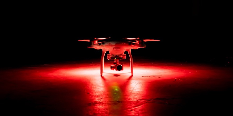
The stock anti-collision lights of the SUA will not be enough to maintain visibility in darkness. Thus, the drone will be equipped with ultra-bright strobing LED lights that the RPIC and VO can see from at least 3 statute miles.
The location of the proposed operations is a mountainous area with thick forests. To help maintain visibility, the SUA will only be operated up to a maximum of 250 feet of horizontal distance.
In the event of a failure of the SUA’s anti-collision lighting system, the operations will be halted immediately. The SUA will be commanded to hover in place while the RPIC informs the rest of the ground crew of the suspension of the operations. In preparation for such an event, well-lit primary and alternative landing points will be designated for the drone. The RPIC will be responsible for maintaining a clear flight path from the position of the SUA to any of the designated landing points at all times.
If either the RPIC or VO loses visual contact with the SUA, operations will be halted and the SUA will hover in place until visual contact can be re-established. If neither the RPIC nor the VO can locate the drone within three minutes, emergency landing protocols will be initiated. In any case, the SUA will be outfitted with a redundant GPS tracker that will aid in tracking it should it crash.
Emergency landing will be done by the RPIC using any of the following options: the Return to Home (RTH) feature, flight via FPV, or flight via real-time telemetry data.
Describe how the RPIC will see and avoid other aircraft, people on the ground, and ground-based structures and obstacles during darkness
Approximately 48 hours prior to the operations, the flight crew will be conducting a daytime survey of the area of the operations. The purpose of the daytime survey is to establish primary and alternative landing points and to familiarize the crew with obstructions and structures in the area. The crew will then practice drone flight in the area, making sure that there are clear flight paths to any of the established landing points.
Landing points will be marked with lights and enclosed with safety tape to discourage non-participants from coming close to them.
Approximately 24 hours before the proposed operations, the RPIC will check for active TFRs in the operations area. This will be done through both the KittyHawk app and the TFR database on the FAA website.
Thirty minutes before the start of nighttime operations, the crew will undergo a procedure for their vision to adjust to low light conditions. This includes activation of lights in the established landing points, turning down of video displays to minimal brightness, and activation of the SUA’s positional and anti-collision lights.
The SUA is outfitted with an ADS-B receiver that will notify the RPIC if there are manned aircraft approaching the area. The RPIC will determine if the nearby aircraft will pose a collision threat. In such cases, the RPIC will yield right of way by immediately reducing altitude to below 200 AGL until the manned aircraft has passed.
As redundancy for the ADS-B receiver, both the RPIC and VO are tasked to continuously scan the skies for other aircraft or possible obstructions.
If non-participants encroach in the area of operations, the RPIC will maneuver the SUA away from them. They will be informed of the ongoing operations by the ground crew and advised of the risks of being inside the operations area. If the area cannot be cleared of non-participants, then the operations will be suspended.
Describe how the RPIC will be able to continuously know and determine the position, altitude, attitude, and movement of the SUA
The SUA will be outfitted with LED position lights installed according to manned aircraft standards – a red light on the left, and a green light on the right. These lights are bright enough to be visible to both the RPIC and the VO at a distance of 3 statute miles. Using the position lights, both the RPIC and the VO can determine the direction in which the SUA is facing.
The RPIC also has access to telemetry data via the video display connected to the SUA’s remote controller. This data will include information on the SUA’s current altitude, distance from the remote controller, horizontal speed, attitude, and battery level. An iPad Mini will be used as a visual display with the brightness turned down to the minimum to maintain low light vision. A backup iPad Mini will be in possession by the ground assistant should be the primary iPad Mini be non-operational for any reason.
What procedures will be followed to ensure all required persons participating in the operation have the knowledge to recognize and overcome visual illusions caused by darkness and understand physiological conditions which may degrade night vision?
All crew members will be trained for Night Operations using the FAA-disseminated sources. This training will focus on the skill to recognize and overcome visual illusions caused by darkness and the physiological conditions which may make night vision difficult.
The main reference for the training materials will be the FAA Helicopter Flying Handbook (FAA-H-8083-21A, Chapter 13), the Airplane Flying Handbook (FAA-H-8083, Chapter 10), and the Pilot’s Handbook of Aeronautical Knowledge (FAA-H-8083, Chapter 17). To ascertain the level of proficiency of the crew members with regards to Night Operations, all of them will take a 20-question multiple-choice exam with a passing score of 16.
The RPIC will be responsible for administering the exam and documenting the results. All the results can be made available upon request. Crew members should have finished the training and passed the exam within one month of the proposed operations.
An electronic copy of the training materials will be disseminated to all crew members for their personal review. Moreover, a copy of the training materials will also be available on-site as a quick reference, if needed.
As part of the pre-operation briefing, the crew will discuss the procedures to follow for nighttime operations, the causes of night illusions and how to avoid them, and the proper techniques for nighttime visual scanning.
NOTE: A copy of the training materials may be attached as part of the waiver request.
Describe how the visual conspicuity of the SUA will be increased to be seen at a distance of 3 statute miles.
To aid in visibility of the SUA, it will be outfitted with ultra-bright LED strobing lights that are rated for visibility of 10 statute miles. Functionality of the strobing lights will be tested as part of the SUA’s pre-flight inspection. The RPIC will be responsible for ensuring that the strobing lights are functioning as intended.
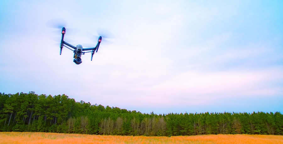
Section 3. sUAS Details
Manufacturer: DJI
Model: Inspire 2
Registration number: xxxxxx
Relevant drone specs and accessories:
| Weight | 7.58 lbs. |
| Max takeoff weight | 9.37 lbs. |
| Max flight time | Approx. 23 minutes |
| Max horizontal speed | 58 mph |
| Remote controller range | 4.3 miles |
| LiDAR Sensor | LiAir 220 from GreenValley International |
| Anti-collision lights | TOPSUN 2.5W LED Strobe Lights |
| Position lights | LUME CUBE Night Flyer Kit |
| GPS tracker | Trackimo Real-Time Drone GPS Tracker |
Section 4: Review Waiver
This section will simply allow you to review all the information and supporting documents you have provided. Check for completeness and accuracy, as an application cannot be amended or improved once it has been submitted.