-
Key Takeaways
-
What Are LP, LPV, LNAV, and LNAV/VNAV?
- What Is RNAV?
- With Vertical Guidance
- Without Vertical Guidance
-
Equipment Requirements for LPV, LNAV, and LNAV/VNAV
- Fail-down
-
The Differences in the Approaches
- If You Have Vertical Guidance (LPV or LNAV/VNAV):
- If You Don’t Have Vertical Guidance (LP or LNAV)
- Differences in Minima
-
Important Additional Terms & Definitions To Know
- Required Navigation Performance (RNP)
- RNP AR
-
Frequently Asked Questions
-
Conclusion
Are you studying for your instrument rating? It can be overwhelming with all the information you need to know.
Many pilots just memorize the answers instead of truly understanding them, especially when it comes to complicated topics like LP, LPV, LNAV, and LNAV/VNAV.
But don’t worry; this guide is here to help!
We’ll explain these approaches, what equipment you’ll need, and why understanding them is important for a safer flying experience.
Key Takeaways
- LPV offers highly precise GPS-based lateral and vertical guidance similar to a Category I ILS.
- LNAV/VNAV provides vertical guidance but typically has higher minima due to altimeter and temperature limitations.
- LNAV and LP approaches offer lateral-only navigation, requiring pilots to descend via step-down fixes to an MDA.
- LP+V provides advisory-only vertical guidance. It’s not an official approach type and is only meant to enhance situational awareness.
What Are LP, LPV, LNAV, and LNAV/VNAV?
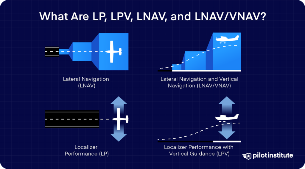
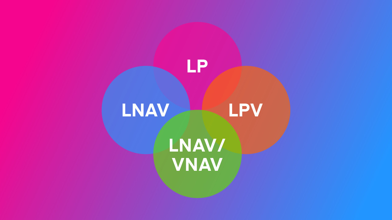
Before we begin to find our way around these acronyms, let’s give them some context. LP, LPV, LNAV, and LNAV/VNAV are RNAV (GPS) instrument approaches.
Each approach provides pilots with navigational guidance to safely reach the runway during instrument conditions. What sets them apart is the type of guidance they offer and the accuracy they can provide.
What Is RNAV?
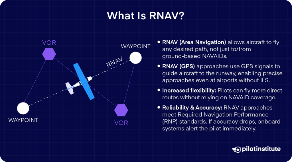
RNAV stands for Area Navigation. RNAV lets you navigate on any desired flight path, not just directly to or from ground-based Navigational Aids (NAVAIDs). RNAV (GPS) approaches are procedures that use GPS signals to guide the aircraft to the runway.
This gives a massive increase in flexibility. Airports that could never get an ILS can still have a precise approach thanks to GPS. Pilots don’t have to plan routes way off the direct path just to fly close enough to be within range of a ground-based NAVAID.
Whenever anyone replaces a tried and tested technology with a new one, there’s always the question of reliability. Will the new system be as accurate as traditional navigation?
Today’s RNAV approaches are built to meet Required Navigation Performance (RNP) standards. This means the navigation system must always maintain a certain accuracy. If its accuracy degrades below the limit, onboard monitoring systems immediately alert the pilot.
With Vertical Guidance
GPS can navigate you to your destination, but to truly rival the ILS, it must also provide vertical guidance.
RNAV approaches have become so advanced that some variants do offer vertical guidance in addition to lateral guidance. This means you get an electronic glide path to follow, just like a glideslope on an ILS.
Vertical guidance allows you to descend smoothly to the runway. There are no step-down altitudes at fixes to break your descent. The glideslope also gives instantaneous feedback to tell you if you’re too high or too low.
Two RNAV approaches offer vertical guidance: LPV and LNAV/VNAV.
Are RNAV Approaches Precision Approaches?
Traditionally, the difference between precision and non-precision approaches was very clear-cut.
Precision approaches were the ones that offered vertical and lateral guidance. Non-precision approaches only offered lateral guidance.
Although LPV and LNAV/VNAV offer vertical guidance, the FAA and ICAO don’t classify them as precision approaches.
LPV, despite being highly accurate, only offers minima comparable to ILS Category I. There’s currently no RNAV approach meeting Category II or III minima. That means no automatic landings or super-low visibility operations in RNAV approaches.
The FAA created a new category for these modern approaches: APV or Approach with Vertical Guidance.
APV approaches are not precision approaches; from a pilot’s perspective, they feel similar to precision approaches.
Localizer Performance with Vertical Guidance (LPV)
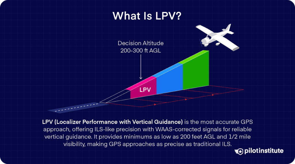
LPV is the most accurate GPS approach. As the name implies, it provides lateral guidance as precise as a localizer and vertical guidance like a glideslope.
GPS technology is great at tracking lateral movement but not very accurate at tracking altitude. So, how does LPV provide accurate vertical guidance?
The answer lies in something called WAAS.
What is WAAS?
WAAS stands for Wide Area Augmentation System. WAAS is a system of ground reference stations that detects and corrects errors in GPS signals. The corrected signals are rebroadcast via WAAS satellites to aircraft receivers.
The result is very similar to an ILS from a pilot’s perspective. Pilots flying an LPV approach will notice the glideslope indicators are just as sensitive as those of an ILS.
The sensitivity even increases as the aircraft gets closer to the runway. This isn’t a coincidence. The FAA intentionally designed LPV to make it easier for pilots to transition from ILS to LPV approaches.
If you look at an LPV instrument approach plate, you’ll see Decision Altitude published as minima, just like a precision approach.
At qualifying airports, LPV minimums can be as low as 200 feet AGL and 1/2 mile visibility, essentially the same as a Category I ILS.
Lateral Navigation/Vertical Navigation (LNAV/VNAV)
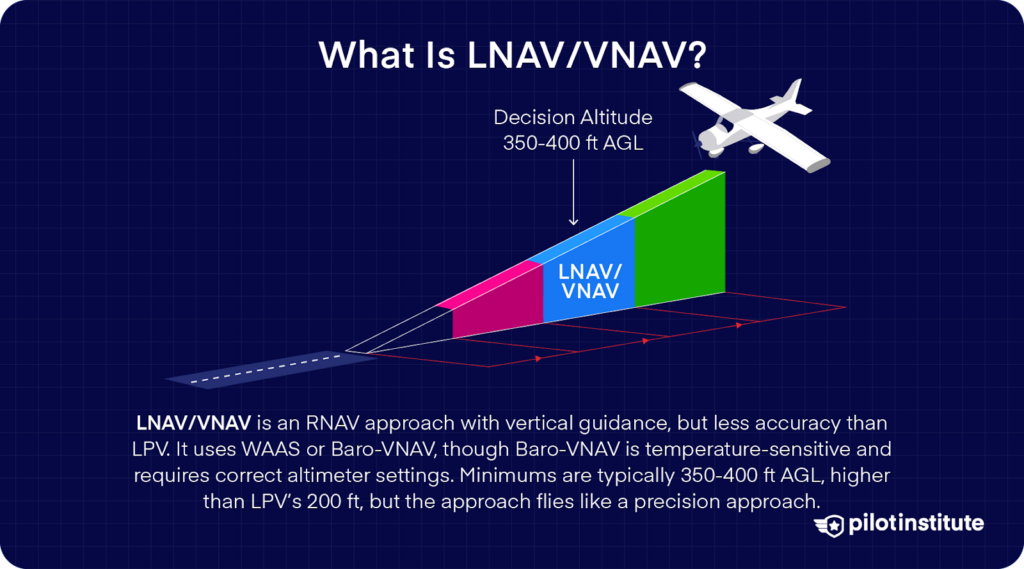
LNAV/VNAV is another RNAV approach that provides vertical guidance but is less accurate than LPV.
This approach can have two possible sources for vertical guidance information. One of them is WAAS. Yes, that’s the same technology LPV uses. However, in cases where the procedure design can’t achieve LPV minima, the approach uses LNAV/VNAV.
Another option is to use a barometric VNAV system. Baro-VNAV systems use the aircraft’s altimeter and flight management system to compute a glidepath.
The downside of using Baro-VNAV is that this system is affected by outside temperature. Extremely cold temperatures can give noticeably incorrect readings.
This is why many procedures prohibit Baro-VNAV use below a certain temperature. This system also depends on the pilot inputting the correct altimeter setting.
That’s why LNAV/VNAV minimums are typically higher, often on the order of 350 ft to 400 ft AGL. Contrast this with the lowest LPV 200 ft minima.
In all other aspects, you’ll fly this approach just like a precision approach. You’ll see glideslope indications on your instruments, and you’ll fly the approach down to DA.
Without Vertical Guidance
Now, let’s talk about the approaches that do not have vertical guidance.
These are the RNAV versions of traditional non-precision approaches like VOR. You’ll be navigating laterally by GPS, but the system won’t give you an electronic glide path to follow.
Instead, you’ll descend using step-down fixes or a constant descent to an MDA (Minimum Descent Altitude).
The two acronyms you’ll encounter here are LNAV and LP.
LNAV (Lateral Navigation)
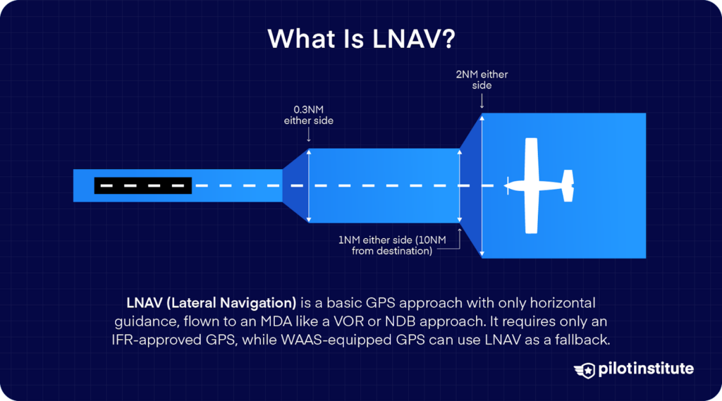
LNAV is the original GPS approach standard. It simply stands for Lateral Navigation and means lateral guidance only. Every RNAV(GPS) approach will have an LNAV line at a minimum because that’s the basic capability: using GPS to navigate a course to the runway.
LNAV approaches are non-precision approaches that provide only horizontal guidance.
You fly them to an MDA. This is the GPS equivalent of a VOR or NDB approach in terms of how you fly it – no glide slope, just follow the course and step down as needed.
The nice thing about LNAV is that it requires no advanced equipment beyond an IFR-approved GPS receiver.
If you do have WAAS, your GPS will still offer LNAV as a fallback or alternative minima if something prevents flying the vertical portion.
LP (Localizer Performance)
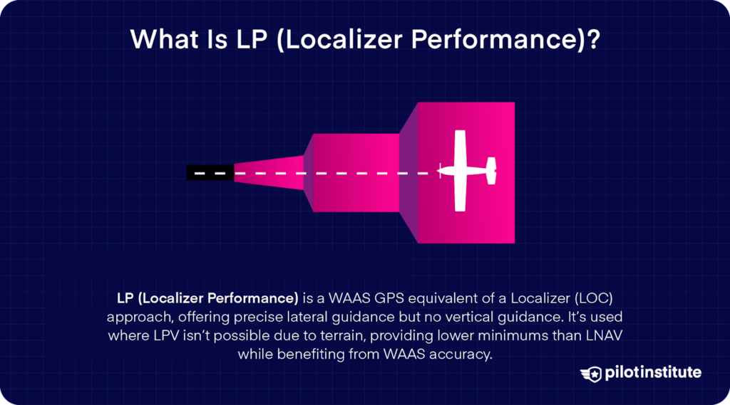
An LP approach is the WAAS GPS equivalent of a Localizer (LOC) approach. As the name implies, it offers comparable accuracy and minimums to a localizer approach. It mimics real localizers by increasing sensitivity as you approach the runway. You do need to have equipment that accepts WAAS signals.
The lack of vertical guidance means you treat the approach like a conventional non-precision approach. Descend to the MDA and fly level till you see the runway.
You may wonder why LP exists at all. LP requires WAAS; if you have WAAS capability, why wouldn’t you fly an LPV approach instead?
The FAA publishes LP minima at locations where obstacles or terrain prevent a vertically guided procedure.
Even if you can’t get a glideslope for an LPV, why not take advantage of WAAS’s improved lateral accuracy? That’s why the FAA publishes LPs only if they allow lower minimums than the LNAV for that approach.
LP+V
Some WAAS navigation systems offer advisory vertical guidance in LP approaches.
LP approaches don’t have an official glideslope. However, some avionics manufacturers use GPS terrain data and the aircraft’s barometric altitude to show an advisory glideslope.
The FAA does not recognize this feature as an official approach type. You won’t find it mentioned on any charts. It’s only meant to be an extra feature to improve situational awareness.
If you do use this system, remember that you still have to obey published step-down altitudes. LP+V does not guarantee obstacle clearance.
Equipment Requirements for LPV, LNAV, and LNAV/VNAV
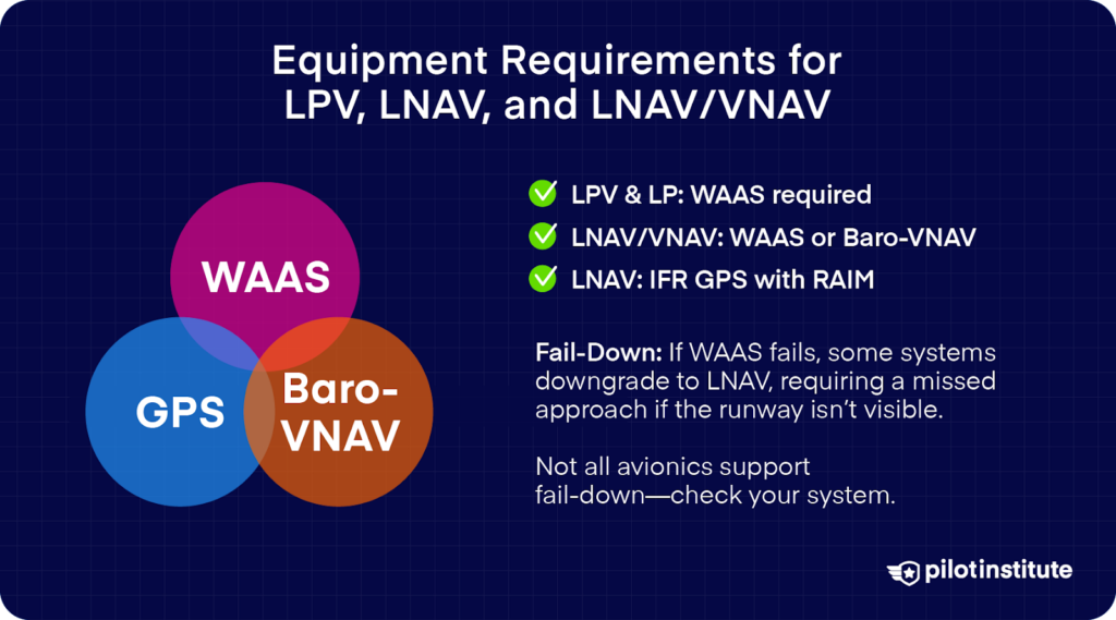
By now, it’s probably clear that your equipment determines which approach minima you can use.
In general, if you’re flying an RNAV approach, the relevant equipment includes:
- An FAA IFR-approved GPS.
- WAAS
Or
GPS RAIM capability. RAIM stands for Receiver Autonomous Integrity Monitoring. This system monitors the GPS’s accuracy.
WAAS already has integrity monitoring built-in. It’s even more stringent than RAIM, so you’re covered if your aircraft supports WAAS.
Let’s break down the requirements for each approach:
- LPV and LP: WAAS is required.
- LNAV/VNAV: Either a WAAS GPS or an approach-certified Baro-VNAV system coupled with your navigation source.
- LNAV: Only requires an approved GPS with RAIM capability.
The navigation equipment installed on your aircraft will only show approaches it can execute. For example, not all WAAS systems support LP, even if they support LPV.
If you select an approach procedure, WAAS systems will display the best level of service available. You can then verify you meet the minimums and fly the approach.
Fail-down
If your WAAS system loses signal, it may not be able to provide the service needed to fly an LPV or LP approach.
Should the failure happen before passing the final approach fix (FAF), the pilot may decide to continue the approach to LNAV or LNAV/VNAV minima.
A failure after the FAF may cause the system to fail down to LNAV only. That means you can continue descending to the MDA but must execute a missed approach if the runway isn’t visible by the missed approach point.
Not all avionics systems offer fail-down capability to LNAV. If your system doesn’t, you must perform a missed approach and either retry or select another approach to land.
The Differences in the Approaches
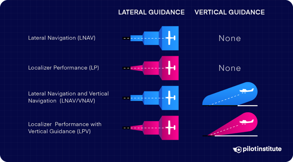
Here’s an overview of the approaches we’ve discussed so far. The major differences come down to whether you have vertical guidance, how you fly the final segment, and how low the minimums are.
If You Have Vertical Guidance (LPV or LNAV/VNAV):
You will fly a glide path down to a Decision Altitude. That means you keep descending on the electronic glide path until you reach the DA.
At DA, you need to decide whether you have adequate visual cues to continue to land. If yes, you can transition to a landing; if not, execute a missed approach.
You can configure and establish a constant descent, reducing workload and simplifying the approach.
As a plus, because of the glide path, you are less likely to dip below safe altitudes at any point.
If You Don’t Have Vertical Guidance (LP or LNAV)
Since you don’t have a glideslope, you’ll have to follow step-down altitudes published at each fix along the approach. Your descent won’t be smooth; it’ll be a bit like climbing down a staircase.
Your approach plate will show an MDA instead of DA. MDA is the Minimum Descent Altitude.
When you reach the MDA, level off and look for the airport. If you see the runway environment before you reach the missed approach point, go ahead and land. Otherwise, a go-around becomes mandatory.
Differences in Minima
Approaches without vertical guidance typically have higher minima than those with vertical guidance.
Vertical guidance lets you get down lower because the criteria assume you’re on a controlled, steady, guided glide path. This means obstacle clearance can be tighter without adding significant risk.
Approaches without WAAS have higher minima than their WAAS counterparts.
Conventional GPS signals offer about a seven meter lateral accuracy and thirteen meters vertical. WAAS cuts that down to 0.6 meters laterally and one meter vertically.
In most cases, LPV will be the RNAV approach offering the lowest minima. That said, there are some exceptions where obstacle clearance rules increase the LPV minima above the LNAV/VNAV minima.
Important Additional Terms & Definitions To Know
Required Navigation Performance (RNP)
If you spend enough time studying RNAV approaches, you’ll encounter the term RNP. RNP stands for Required Navigation Performance.
In simple terms, RNP tells you the navigation accuracy and integrity that must be maintained for a particular operation. It’s essentially RNAV with onboard performance monitoring and alerting.
The aircraft’s navigation system continuously monitors how accurately it knows its position and will alert the crew if it drifts out of tolerance.
For example, an RNAV (GPS) approach typically has an RNP of 0.30 (nautical miles). This means the system must keep the aircraft within 0.30 NM of the intended path 95% of the time. If it can’t, it will warn the pilot. You’ll get an “integrity alert” or “LOI” (Loss of Integrity).
RNP basically dictates how tight the approach course is. RNP 0.3 is precise enough to safely execute an approach and landing.
RNP AR
In approach procedures, the regular RNAV(GPS) approaches we’ve been discussing fall under the spec called RNP APCH (Required Navigation Performance Approach).
FAA charts refer to these as RNP approaches titled “RNAV (GPS) RWY XX”.
Don’t confuse this with “RNP AR” – that’s a special Authorization Required class of approach for difficult operations.
You’ll find these often around tough terrain, requiring special training and equipment, for example, an approach titled “RNAV (RNP) RWY XX”).
For standard LPV/LNAV/VNAV/LNAV approaches, you, as a pilot, just need to know that your equipment needs to meet the RNP value and alert you if it doesn’t.
Frequently Asked Questions
- Why are LPV minimums lower than LNAV/VNAV?
LPV uses WAAS to improve GPS accuracy from 7 meters to 1 meter. Highly precise guidance allows the FAA to lower minimums without significantly increasing risk.
LNAV/VNAV use Barometric vertical guidance, which is affected by temperature and altimeter errors.
LNAV/VNAV can use WAAS for vertical guidance, but the difference in obstacle clearance standards lead to higher minimums than LPV.
- Is LPV or ILS more accurate?
LPV is just as accurate as a Category I ILS, the most common type of ILS system. However, ILS categories II and III have even lower minimums. There are no LPV procedures that compare to that.
- What is LNAV used for?
LNAV is the most basic type of RNAV approach guidance.
LNAV does not use WAAS. This reduces its accuracy and raises its minimums. This type of approach only offers lateral guidance – no vertical guidance.
The absence of WAAS means you must use RAIM (Receiver Autonomous Integrity Monitoring), an onboard system, to track system accuracy.
- What are the benefits of VNAV?
You might have a slight misconception there – let’s clear that up. There’s no such thing as a ‘VNAV approach’.
VNAV is a type of flight control mode in an aircraft’s autopilot. In the context of GPS approaches, only LNAV/VNAV supports a baro-VNAV for vertical guidance.
Vertical guidance gives you a continuous, stable descent path to the runway.
This reduces the risk of accidents like controlled flight into terrain. It’s also more fuel efficient, reduces pilot workload, and allows lower minimums due to greater safety margins.
- Do you need WAAS for LNAV/VNAV?
Not necessarily. You can use WAAS for LNAV/VNAV, but it is not a requirement.
It’s possible to use a Barometric VNAV instead, but you must remember it is affected by extreme temperatures. Barometric VNAVs also rely on the pilot inputting the correct altimeter setting.
General aviation aircraft are unlikely to have a Barometric VNAV system onboard. WAAS is the more practical method for GA aircraft to fly LNAV/VNAV since it’s easier to install a WAAS-enabled GPS unit.
- What is LNAV+V?
LNAV+V is a term you might see on Garmin (and some other) avionics when flying certain approaches.
It stands for “LNAV plus Vertical,” essentially LNAV with advisory vertical guidance. It is not an official minimum line published by the FAA – you won’t see “LNAV+V” on government charts.
If your Garmin navigation system receives sufficient SBAS signals, your LNAV approach is likely capable of showing advisory vertical guidance.
Your GPS Status page will show the “3D Diff Nav” notification to let you know you’re receiving the required signals.
As long as you’re flying a GPS approach that doesn’t have LNAV/VNAV or LPV, your GPS will automatically upgrade the approach from LNAV to LNAV+V.
You’ll see advisory glideslope indications on your display, and the guidance mode will say GPS LNAV+V.
Conclusion
We hope you now have a better understanding of LPV, LNAV, and LNAV/VNAV approaches. Each approach has its nuances and it’s vital to know what these differences are.
Practicing these approaches strengthens your fundamentals and prepares you for instrument flight. If you see an LPV, LNAV, or VNAV approach on your chart you’ll now know what to do.
If you want a better understanding of IFR in general you can take a peek at Garmin G1000 Made Easy courses.
