-
Key Takeaways
-
The Science Behind Temperature Inversions
- What Is a Temperature Inversion?
- Normal Lapse Rate Refresher
-
Common Types And How They Form
- Surface-Based (Radiation) Inversions
- Frontal Inversions
- Subsidence / High-Pressure Inversions
- Valley & Basin Cold-Pool Inversions
- Capping (Elevated) Inversions
-
Meteorological Consequences
- Stability & Cumulus “Lid”
- Trapped Moisture, Smoke, and Pollutants
- Fog and Low Stratus
- Wind Shear & Low-Level Jet
- Turbulence & Mountain Waves
- Icing & Freezing Rain
-
Why Pilots Should Care
- Aircraft Performance Surprises
- Takeoff/Landing LLWS
- Visibility Challenges
- Hidden Turbulence Zones
- Icing Encounters
-
Detecting and Forecasting Inversions
- Skew-T / Log-P Soundings
- Forecast Products Toolbox
- Visual In-Flight Indicators
-
Operational Strategies For Pilots
- Departure & Climb Techniques
- Approach And Landing Adjustments
- VFR Navigation Tips
- Mountain & High-Desert Ops
- IFR & Icing Mitigation
-
Training And Scenario Integration
- Simulator Scenarios
- Common Student Errors
-
Case Studies And Lessons Learned
- Delta 191 (1985)
- GA Sunset Radiation Fog Accident
-
Myths, Misconceptions, And Quick Facts
- “Temperature inversions only happen in winter.”
- “Inversions always mean smooth, stable flying conditions.”
- “Just climb to escape icing.”
- “You can easily detect inversions visually from the cockpit.”
-
Conclusion
It is 0600 local, and the taxi feels effortless. Yet just after liftoff, at 500 feet above the ground, the airspeed indicator suddenly spikes.
A 40-knot tailwind has you wrestling with the controls, and you’re fighting to hold your climb. You’re flying through sharp changes in wind and temperature just above the ground.
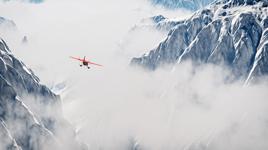
That kind of smooth and quiet atmosphere can be deceiving. Hidden in plain sight, a surface inversion is at work.
The good news is you don’t have to be caught off guard. If you understand how inversions form and how you can spot them before takeoff, you can dodge trouble while still on the ground.
Let’s walk through what inversions are, how they affect both weather and flight, and practical steps you can use to anticipate them before releasing the brakes.
Key Takeaways
- Temperature inversions occur when warmer air traps cooler air beneath.
- They form through radiational cooling, subsiding air, or warm-air advection overrunning cooler surface layers.
- Types include radiation, frontal, subsidence, and terrain-related inversions.
- Inversions are detected using radiosonde data, forecasts, performance anomalies, or indirect signs like trapped pollutants.
The Science Behind Temperature Inversions
What Is a Temperature Inversion?
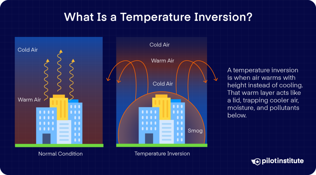
A temperature inversion is exactly what it sounds like. Instead of getting cooler as you go higher in the sky, the air actually gets warmer.
That creates a sort of invisible lid. The warmer layer above acts like a static, calm ceiling that traps whatever is below.
In meteorological terms, it’s an increase in temperature with altitude.
Normal Lapse Rate Refresher
Every pilot knows that under standard atmospheric conditions, temperature drops with altitude. The ICAO standard lapse rate is about 2 °C for every 1,000 ft you climb.
Is this rate the same everywhere? It depends. If the air is dry without clouds or moisture, it can cool even faster at around 3 °C per 1,000 ft. This is known as the Dry Adiabatic Lapse Rate, or DALR.
But when there’s moisture, the cooling slows. Why is this?
Well, as water vapor condenses, it releases heat. The saturated parcel then cools at a gentler rate, roughly 1.5 °C per 1,000 ft. This is the Saturated Adiabatic Lapse Rate, or SALR.
Common Types And How They Form
How do inversions happen? Temperature inversions can arise from different processes. As a result, they can also fall under different types depending on how they were formed.
Now, let’s talk about the ones you’re most likely to encounter.
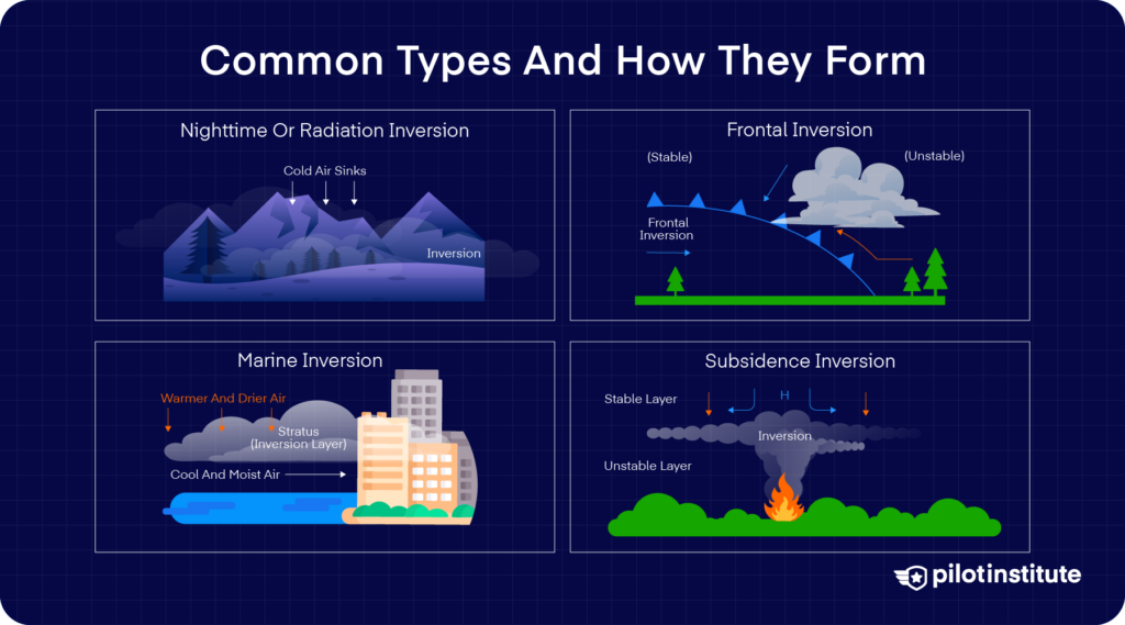
Surface-Based (Radiation) Inversions
When the night is clear and the winds are light, the ground cools quickly through radiation. The air touching the ground follows, and it gets distinctly cooler than the air just a few hundred feet above.
That creates a surface-based inversion. They’re often just a few hundred to around 1,000 ft deep with warmer air sitting on top of cooler air.
The layering acts like a lid that traps moisture. This is also sometimes the reason why we get fog in the morning.
Frontal Inversions
Another type forms when warmer air glides over colder air at the surface. You’ll typically find it during warm frontal passages. In that case, the cold air remains trapped below while warmer air moves above, which makes an inversion layer aloft.
What do you get from this setup? There might be freezing rain when precipitation falls into the colder surface layer, so watch out for icing.
Subsidence / High-Pressure Inversions
Under high-pressure systems, sinking air warms by compression as it descends. That creates a dry, warm layer aloft that blankets cooler air below, and we call this a subsidence inversion.
These layers can range from a few thousand feet into the upper troposphere. It can also persist for days, especially in stagnant weather patterns.
Valley & Basin Cold-Pool Inversions
In valleys and basins on clear and calm nights, the dense, cooling air can drain downslope. It eventually accumulates in the low terrain, which forms a cold-air pool beneath warmer air aloft. It can often trap fog and pollutants and create a strong local inversion.
Capping (Elevated) Inversions
A capping inversion, or “cap,” is a warm layer several thousand feet aloft that suppresses convective growth beneath it. It keeps cumulus clouds from rising past that level.
However, when surface heating or dynamic lifting breaks the cap, it can unleash explosive thunderstorms.
Particularly in the Great Plains, a strong cap can build and give way under energy, leading to tornadic storms.
Meteorological Consequences
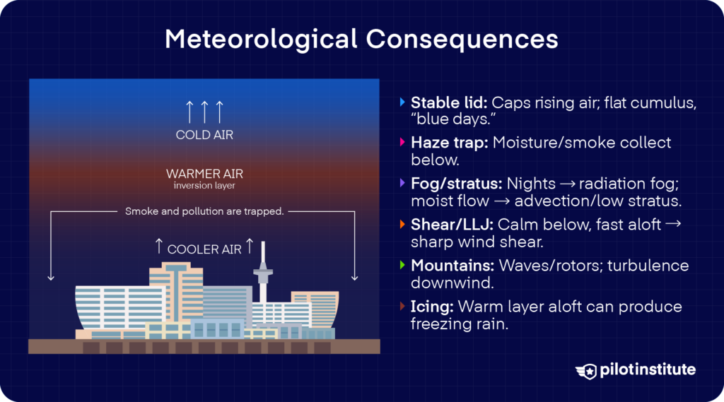
Stability & Cumulus “Lid”
Have you ever heard of the phrase “blue day”? It’s what pilots call a day with good, clear flying conditions.
Sometimes, it’s when cumulus clouds flatten at their tops because they cannot rise past that warm layer above.
You have temperature inversions to thank for this. It forms a stable layer that effectively caps vertical air movement.
You might note smooth, gentle flying conditions, or even wonder why the haze and pollution seem trapped just below.
Trapped Moisture, Smoke, and Pollutants
Remember that inversions act like a lid on the atmosphere. That said, it can become a trap for moisture, smoke, and other pollutants near the surface. That often creates a brownish or grayish haze visible during climbout.
The trapped layer can distort cellular signals, too. This phenomenon is known as anomalous propagation, where radar beams bend and reflect incorrectly through the stable layer.
Fog and Low Stratus
Inversions help form two familiar types of low clouds. When surface air cools faster than the air above on clear nights, radiation fog can develop in the trapped layer.
In other cases, moist air moving horizontally under inversion conditions can create advection fog or low stratus.
Either way, you need to plan with caution. Do you have extra fuel reserves? Where’s your alternate aerodrome? Keep these things in mind when low visibility is possible.
Wind Shear & Low-Level Jet
Temperature inversions often precede wind shear and the formation of low-level jets. How does this happen?
When a stable boundary develops at night, surface winds grow calm while stronger winds continue aloft, free from surface friction.
These faster upper winds accelerate into a low-level jet. It leaves a steep gradient between calm air below and swift air above.
Turbulence & Mountain Waves
When inversion layers form above mountainous terrain, they can lead to complex airflow patterns. There could be rotor clouds below and lenticular clouds above.
These mountain waves create mechanical turbulence that you can encounter on the downwind side of ridges.
Icing & Freezing Rain
If inversions affect the vertical temperature profile, then that means that snow can fall, then melt, then freeze again as it descends into colder air near the surface.
That is the classic setup for freezing rain, which you’ll need to anticipate while flight planning and in the air.
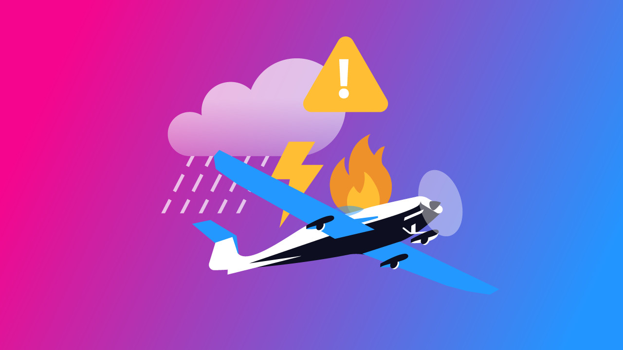
Why Pilots Should Care
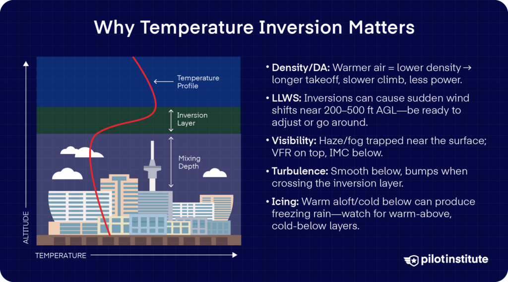
Aircraft Performance Surprises
What happens to air density as it gets warmer? It decreases. That means a higher density altitude, which is bad news for your aircraft’s performance.
A spike in temperature could mean loss of engine power, slower climbs, and longer takeoff rolls. They’re all the performance penalties that you might not anticipate mid-climb.
We recommend learning more about the difference between pressure altitude and density altitude as well.
Takeoff/Landing LLWS
Inversions can also create strong low-level wind shear. Imagine starting your climb, only to feel a tailwind spike hit around 300 ft AGL. That sudden shift can upset your pitch and power settings in an instant.
You have to recognize these kinds of shears to handle abrupt speed changes on climb or descent.
Visibility Challenges
Under an inversion, pollutants, haze, or fog can cling near the surface while skies above are clear. If you’re coming down from the air, that can lull you into a false sense of security.
VFR conditions at altitude might tempt you, only for the destination to be socked in by hidden haze or fog when you descend.
Hidden Turbulence Zones
Although the air under an inversion layer often feels smooth, turbulent rotor zones can lurk along the interface between stable and unstable air.
You may not feel anything on the surface, then suddenly encounter bumps as you cross that boundary in your climb or descent.
Icing Encounters
An inversion can set up a vertical temperature profile that is cold below and warmer aloft. These create the perfect conditions for melting snow aloft, which then refreezes on descent into subzero air.
Always stay on the lookout for two distinct layers: warm above, cold below, so you’re not caught off guard by supercooled droplets.
Detecting and Forecasting Inversions
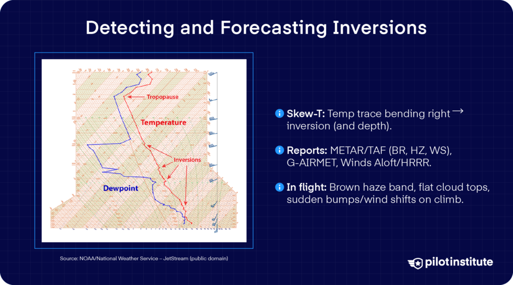
Inversions are dangerous, but they’re also completely avoidable. How can you spot them and where should you look? Let’s find out.
Skew-T / Log-P Soundings
An atmospheric sounding, or sounding for short, shows you the vertical profile of temperature, dewpoint, and winds above a given location.
Skew-T Log-P diagrams are especially useful for detecting inversions. Look for the “kink” where the temperature trace bends to the right above cooler air. That shows you where and how deep the inversion lies.
These soundings are available through online resources like NOAA’s RAP and SPC sounding pages.
Forecast Products Toolbox
Aside from that, METAR and TAF reports let you find out about any weather phenomena related to inversions.
They can include visibility codes like BR (mist) and HZ (haze), or wind shear codes like WS.
G-AIRMETs are particularly useful for alerts on low-level wind shear. You can scan vertical profiles for hints of inversions from models like the NWS HRRR.
To check for wind patterns that support stable layers aloft, check out Winds-Aloft forecasts.
Visual In-Flight Indicators
That said, the naked eye is still one of the quickest tools for spotting an inversion. What signs should you check for?
If you see or experience:
- A sharp brown haze layer
- A flat cumulus cloud deck
- Sudden turbulence when climbing through an abrupt layer
Those are textbook indicators that you’re crossing an inversion boundary.
Operational Strategies For Pilots
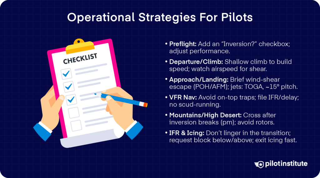
Any time you’re planning a flight, even a small “Inversion present?” check box in your navigation log can be a powerful reminder. You’ll be sure to catch inversions before take-off so you can adjust your performance expectations right from the start.
What more steps can you take to stay safe? Let’s talk about them.
Departure & Climb Techniques
So you suspect a low-level inversion, what should you do?
Plan for a shallower climb after takeoff to build airspeed before you enter a potential low-level jet. Pitch alone might not be a sufficient indicator, so keep an eye on airspeed trends.
Look for sudden drops or shifts, which are often your first clue to wind shear just above you.
Approach And Landing Adjustments
Remember that wind shear is especially hazardous on approach and departure, when you’re slow and close to the ground. What’s your go-around strategy for wind shear?
Brief your escape maneuver ahead of time. If your POH/AFM has a wind shear escape procedure, include that in your briefing and commit it to memory.
For most jets, it’s recommended to aim for a pitch of about 15° and Take-Off/Go-Around (TOGA) thrust if sudden wind shear hits.
VFR Navigation Tips
If your destination is beneath cold-pool stratus or dense haze, you don’t want to place yourself in a false “on-top” situation. It’s best to play it safe.
File IFR, delay your arrival, and avoid scud-running below cloud decks. You’ll keep your options open without relying too much on visual cues alone.
Mountain & High-Desert Ops
In alpine or high-desert environments, surface heating in the afternoon starts to break that inversion cap, and turbulence diminishes. That’s your safest window to plan ridge crossings.
Always steer clear of rotor zones around ridges. Remember, those turbulent areas at the inversion interface can easily overwhelm control, even for experienced pilots.
IFR & Icing Mitigation
When you’re flying in icing-prone conditions under a temperature inversion, never straddle in the middle of a transition layer.
You can always request and maintain a block altitude entirely below the warm layer or bang out above it. Stay aware of icing levels. If icing does occur, you’ll have the vertical maneuverability to escape quickly.
Training And Scenario Integration
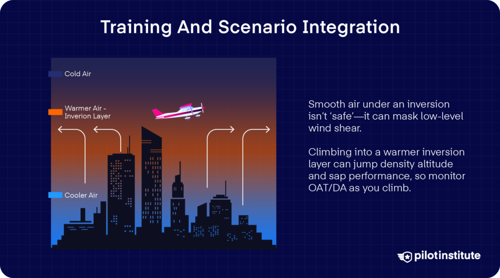
Now here’s a question for all the CFIs out there: How can you demonstrate an inversion to your students in real life?
Carrying a handheld temperature probe on training flights can make a real difference. As you climb higher, you can directly measure the lapse rate every thousand feet. Your students can then see how often that rate flattens or inverts.
Log those readings to make the concept of temperature inversion feel more tangible and even memorable.
Simulator Scenarios
Under 14 CFR 121.424(c), pilots in scheduled air carriers are required to undergo windshear simulator training. But wherever you are in aviation, it’s good practice to train yourself regularly.
The FAA’s Advisory Circular AC 120-50A spells out how simulators must be designed to include lifelike cues. For example, you have to train on wind shear encounters before and after rotation speed, and on approach.
Common Student Errors
Just because the air below an inversion is smooth, you might think it’s safe. Big mistake. That glassy calm can hide dangerous shear or quirks in your aircraft’s performance.
Ignoring the density altitude rise you can experience mid-climb is another common oversight. You might notice your aircraft suddenly perform as though you’re at a much higher altitude.
One effective strategy in building your awareness of sudden performance shifts is calculating the density altitude yourself at various flight levels.
Case Studies And Lessons Learned
When we look back at real-world flying, some of the most valuable lessons come from what others have faced in the cockpit. A few accidents show how quickly conditions can shift when the atmosphere sets its own traps.
The common thread isn’t always apparent at first, but it holds a lesson for anyone paying attention. These cases have shown us why inversions are a threat we need to take seriously.
Delta 191 (1985)
On August 2, 1985, Delta Flight 191 was descending toward Dallas/Fort Worth when it encountered one of the most treacherous weather hazards you can encounter: a microburst hidden beneath a thunderstorm.
As the L-1011 passed through the rain shaft, strong downdrafts spread outward. It produced a sudden shift from headwind to tailwind, and what does that mean for us pilots? A rapid loss of lift.
The microburst forced the jet down short of runway 17L, where it struck the ground and broke apart.
The accident showed the world just how dangerous microbursts and low-level wind shear could be, especially when masked by convective storms. But more than that, it exposed the limits of ground-based detection at the time.
From then on, it drove the development of airborne wind shear warning systems. Delta Flight 191 became the catalyst for the widespread deployment of early warning systems and a windshear avoidance philosophy.
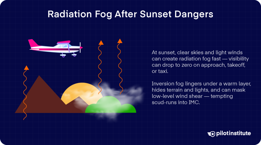
GA Sunset Radiation Fog Accident
Remember how temperature inversions can also cause fog? Here’s a cautionary tale in general aviation.
On September 13, 2003, there was a case of a Mooney M-20C that was attempting to locate a private grass strip near Monticello, Georgia, when it flew into dense morning fog.
Even though the flight was conducted under VFR, instrument meteorological conditions prevailed. The fog obscured the terrain and made visual navigation almost impossible.
A witness jogging nearby even recalled hearing the aircraft overhead but could barely see it through the low visibility before it disappeared toward a wooded hill.
Moments later, the passerby heard the sound of impact. Investigators determined the pilot had been searching for the strip in weather that demanded instrument capabilities.
This accident only proves how dangerous scud running can be, especially in fog. The lesson? You must never press VFR into IMC, with or without any margin to escape.
Myths, Misconceptions, And Quick Facts
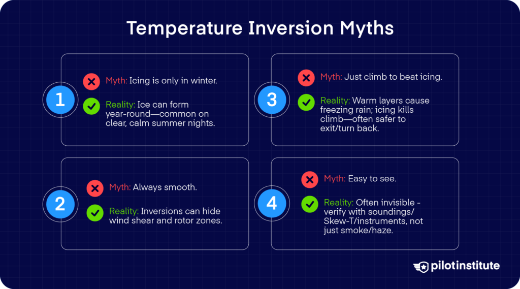
“Temperature inversions only happen in winter.”
Just because inversions are more common in the winter doesn’t mean they only exist in winter. That’s a dangerous assumption to make.
You’ll find inversions any time the right conditions appear. That means they can also occur in summer, particularly over clear, calm, dry nights.
Research in places like the High Arctic and mountainous regions confirms they can appear year-round.
“Inversions always mean smooth, stable flying conditions.”
Inversions do cap convection and suppress turbulence, and they could give you that impression of serenity. But don’t let it fool you.
Remember that those stable layers can hide sharp wind shear or rotor zones that can bite you during climb or approach.
“Just climb to escape icing.”
You might think climbing will get you out of icing, but that warm-layer trap can get you in a lot of trouble. There are hazards with icing, and every pilot needs to be aware of them.
Freezing rain forms when snow melts in a warm layer aloft and refreezes in cold air below. You might think you can climb into the warm layer that causes it, but can you?
Remember that lift is compromised in an iced airfoil. And with ice already on your aircraft, climbing may be impossible and dangerous. Often, the better and safer move is to reverse course to escape icing altogether.
“You can easily detect inversions visually from the cockpit.”
You might trust your eyes to spot an inversion, especially if you see smoke or haze layering, but that can be deceptive.
Many inversions are completely invisible, and they might give no visual cues at all. The only reliable detection comes from instruments like radiosondes, Skew-T charts, or remote sensors.
While fog or a smoke layer may hint at an inversion, many are invisible to your eyes. That “lid” in the sky often hides quietly above you, unnoticed unless you check soundings or instruments.
Conclusion
Temperature inversions aren’t just a minor threat to us pilots. They’re common, sometimes invisible, and always worth your attention.
They can hide wind shear, trap icing layers, and quietly erode aircraft performance. The real threat comes from believing the myths that make you dismiss them.
Your best defense is awareness. Review forecasts, adjust performance expectations, and brief for wind shear with the same focus you give any other risk.
Inversions may not always be obvious, but their effects are. Treat them seriously and plan ahead. You’ll be certain to manage with skill and confidence.