-
Key Takeaways
-
What Are Microbursts?
- Formation of Microbursts
- Can More Than One Microburst Occur in the Same Weather System?
-
Downdrafts and Microbursts
- Downdrafts, Downbursts, Microbursts, Macrobursts
- The Danger of Microbursts
-
Wet vs. Dry Microbursts
- Wet Microbursts
- Dry Microbursts
- The Difference
-
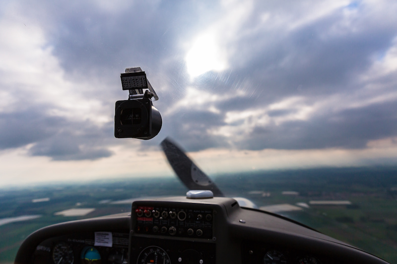
Impact on Aviation
- Flying Into a Microburst
- Cautionary Tales
-
Recognizing and Avoiding Microbursts
- Visual Indicators for Pilots
- Microburst Detection Systems
- Training for Microburst Encounters
-
Conclusion
On August 2, 1985, Delta Air Lines Flight 191 was moments from landing at Dallas/Fort Worth. Then, as the Lockheed L-1011 descended, an invisible force—sudden and fierce—engulfed the aircraft.
A strong downward rush of air sent it plunging uncontrollably. The pilots fought to recover, but the wind shear was too strong. The jet slammed into the ground six thousand feet short of the runway, taking the lives of 134 people.
This weather phenomenon is called a microburst, one of aviation’s deadliest threats. They are violent, localized downdrafts that strike without warning. Detecting them is difficult, which makes final approach and landing especially dangerous.
But the question remains: How can we better prepare for these invisible but deadly forces of nature?
Key Takeaways
- Microbursts can cause severe wind shear and downdrafts.
- They are difficult to detect, making pilot awareness and training vital.
- Both wet and dry microbursts pose significant risks during takeoff and landing.
- Technological advancements aid in detection, but pilot vigilance remains essential.
- Historical accidents highlight the importance of understanding microbursts.
What Are Microbursts?
To answer this question, we first have to understand exactly what we’re dealing with.
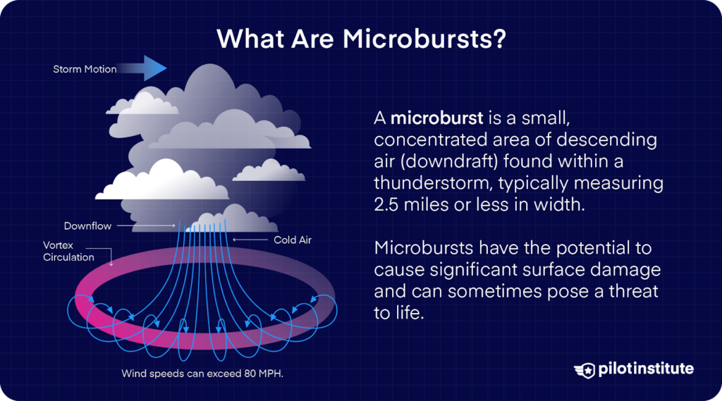
During a thunderstorm, you might experience a powerful blast of air rushing straight down, slamming into the ground, and spreading out in all directions. That’s a microburst. They’re small but intense downdrafts that can cause sudden changes in wind speed and direction.
The FAA defines a microburst as a small-scale, intense downdraft that, when reaching the surface, spreads outward symmetrically or asymmetrically in all directions from the downdraft center. It is the most severe type of wind shear.
So, what makes microbursts so dangerous? They’re a form of low-level wind shear, which is a rapid shift in wind speed or direction near the ground. Microbursts can be catastrophic, especially when you’re taking off or landing.
They create a brief but violent burst of wind within an area as narrow as 2.5 miles. The downdrafts can cause you to sink as fast as 3,000 to 5,000 feet per minute—even up to 6,000 FPM in extreme cases! Horizontal wind speeds near the surface can be as fast as 45 knots, resulting in a 90-knot wind shear from headwind to tailwind across the microburst.
In seconds, an aircraft can be forced into an uncontrollable descent, leaving you with barely any time to react.
Formation of Microbursts
Where does it all start? With the development of a thunderstorm, when water droplets or hailstones get suspended within the updraft of warm air. Sometimes, these updrafts are so powerful that they hold large amounts of precipitation in place.
But these updrafts don’t last forever. Many factors can trigger evaporational cooling, where the cooled air sinks and weakens the updraft. When that happens, it can no longer support the heavy core of rain and hail. With nothing left to lift it, the core has nowhere else to go but down.
And as it crashes to the surface, the core spreads out in all directions. The place where the microburst first hits the ground will experience the highest winds and greatest damage.
Can More Than One Microburst Occur in the Same Weather System?
Absolutely! Microbursts don’t always occur alone. In fact, a single storm system can produce multiple microbursts, where they each strike different areas in quick succession.
If several microbursts are present, a series of horizontal vortices can form near the ground. This is because several microbursts are being embedded in one another. In these vortices, you should also watch out for very powerful updrafts, roll forces, and downdrafts.
This makes the microbursts even harder to predict since you might escape one downdraft only to be hit by another moments later. You should stay alert for additional microbursts if you’ve already encountered or observed one.
Downdrafts and Microbursts
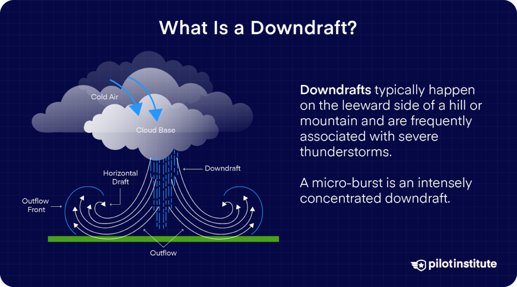
Not all thunderstorms are the same, but many have one thing in common: downdrafts. Their powerful downward-moving air currents can create sudden and damaging winds near the surface.
Even though they account for less than 10% of severe wind reports in the eastern United States, microbursts cause around 25% of severe wind damage (measured in U.S. currency) in states located east of the Rocky Mountains.
Downdrafts, Downbursts, Microbursts, Macrobursts
When it comes to this topic, some terms often get mixed up: downdrafts, downbursts, microbursts, and macrobursts. Are you also confused about the difference? Then, let’s straighten things out.
First, we’ve got downdraft. This is any downward-moving air in a thunderstorm. Downdrafts are common in thunderstorms and vary in intensity. They can be weak and short-lived, while others become strong enough to cause significant damage.
A powerful downdraft that hits the ground and spreads out in all directions is called a downburst. They can produce straight-line winds as strong as tornadoes but without rotation. They’re a major hazard for aviation and structures.
Depending on the area they cover, there can be two kinds of downbursts:
- Microbursts are small but mighty. They can cover an area of 2.5 miles or less. Microbursts last only a few minutes but can generate sudden, extreme wind shifts.
- Macrobursts extend over 2.5 miles or more. While they last longer and affect a wider area, their impact is often more gradual compared to the intense, localized force of a microburst.
The Danger of Microbursts
Which is more dangerous, microbursts or macrobursts? While both cause damaging winds, microbursts are a much greater hazard. They happen quickly, often with little warning, and affect a small area. You might not know you’re in danger until it’s too late.
When you fly into a microburst on approach or departure, you’ll first encounter a strong headwind, which will give you a brief lift.
But almost immediately, you’ll get hit with a sudden downdraft, followed by a tailwind that rapidly reduces airspeed.
Without enough altitude or time to react, the aircraft can lose lift and crash before you can recover. And this exact scenario is what happened to Delta Air Lines Flight 191 in 1985.
Wet vs. Dry Microbursts
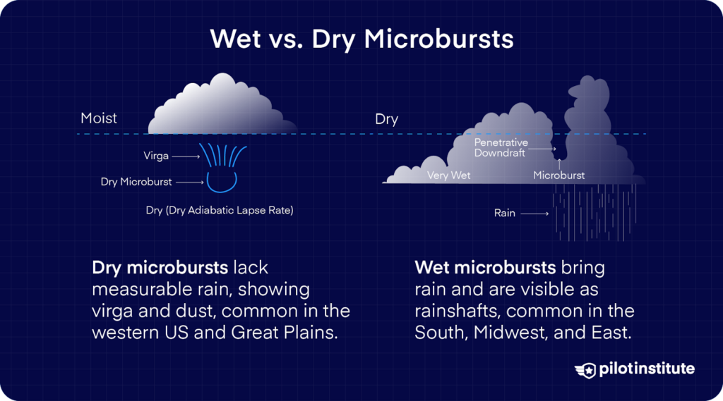
Microbursts may be small in size, but they pack a serious punch. They come in two types: wet microbursts and dry microbursts. These types have different characteristics that affect how they appear and how dangerous they can be.
Wet Microbursts
Have you ever seen a sudden burst of rain crashing down from a thunderstorm? Then, you might have witnessed a wet microburst in action. These occur in humid climates where thunderstorms produce visible precipitation.
As rain falls, some of it evaporates, cooling the air and causing it to sink rapidly. When this cold, dense air reaches the ground, it spreads out violently, creating powerful and unpredictable wind shear.
You can spot wet microbursts visually because they’re accompanied by measurable rain. These rainshafts can appear as curtains reaching the ground. But just because they’re visible doesn’t make them any less dangerous.
Strong downdrafts and sudden wind shifts can make landing or taking off extremely difficult. An aircraft might experience a brief lift due to a strong headwind, only to be forced into an uncontrolled descent as the wind suddenly reverses.
In the US, microbursts are common in the South, Midwest, and East.
Dry Microbursts
But microbursts don’t just occur when it rains. They can also happen in arid climates where little to no measurable precipitation reaches the ground. These are called dry microbursts, and they form when rain evaporates entirely before hitting the surface. Instead, you get a sudden burst of sinking air.
The evaporation process cools the air rapidly. The air then becomes denser and plummets downward at high speed.
How can you spot a dry microburst? Watch out for virga or rain that evaporates before reaching the ground. So, instead of a visible rain shaft like in a wet microburst, you might only see streaks of precipitation that disappear mid-air.
Once the downdraft reaches the surface, it kicks up dust and debris, forming a dust ring. However, by the time this warning appears, it may already be too late if you get caught in its path.
You’ll most likely run into dry microbursts in the Western US and the Great Plains.
The Difference
Both wet and dry microbursts produce strong winds over a small area. But because wet microbursts are more visible, you might have a slight advantage in detecting them early.
Dry microbursts, on the other hand, are often invisible. This means they can be more unpredictable.
Either type can be deadly if encountered at low altitude, so you should always stay on high alert when flying through stormy weather.
Impact on Aviation
Takeoff and landing are the most pivotal phases of flight. You’re at a low altitude with little time to react and no room for error. That’s why encountering a microburst during these moments is one of the most dangerous situations you can face.
Flying Into a Microburst
From your point of view, what happens if you fly into a microburst?
At first, you might experience a strong headwind, which briefly increases your airspeed and gives you a false sense of stability. This can fool anyone easily, and could lead to disaster during approach.
Within seconds, everything changes. The aircraft enters the core of the microburst, where a powerful downdraft forces you downward at an alarming rate. And while you struggle to maintain altitude, the wind suddenly shifts to a tailwind, further robbing your wings of lift and causing a rapid loss of airspeed.
If you don’t act immediately, you could be forced into an uncontrollable descent before you even reach the runway.
This is just as deadly during takeoff. You’re at low speed and climbing gradually, meaning any sudden loss of airspeed could prevent you from gaining altitude. Instead of climbing away from danger, you might find yourself sinking back toward the ground with no way to recover.
Also, microbursts don’t always come with heavy rain or prominent storm activity. The FAA warns against flying beneath convective clouds producing virga, as these conditions can indicate the presence of a dry microburst.
These downdrafts can accelerate downward, spreading out violently upon reaching the surface. When this happens near an airport, an approaching or departing aircraft has almost no time to react.
Cautionary Tales
Unfortunately, history has shown just how deadly microbursts can be. Several major aviation disasters have been linked to microburst-induced accidents. Let’s take a look at some of them.
- One of the earliest of these accidents happened in 1975. Eastern Air Lines Flight 66, a Boeing 727, crashed on approach to JFK Airport.
As the aircraft descended, it encountered a powerful microburst. The flight crew was late in recognizing and correcting the high descent rate, probably relying upon visual cues rather than on flight instrument reference.
Unable to recover, the jet struck approach lights short of the runway and then towers 8 and 9. 113 people lost their lives on the flight. - Forty-two years ago, in 1982, Pan Am Flight 759 crashed shortly after takeoff from New Orleans International Airport. According to witnesses, the Boeing 727 was able to climb to about 100 feet above the ground when it suddenly began to sink. The aircraft had flown into a microburst.
Unable to climb, it struck trees and crashed into a residential neighborhood, killing all 145 passengers and crew, along with eight people on the ground.
This accident became a tragic lesson on how microbursts could be just as deadly during takeoff as with landing. - Now, the most well-known microburst accident occurred in 1985. Delta Air Lines Flight 191, a Lockheed L-1011 TriStar, was flying from Fort Lauderdale to Los Angeles with a stop in Dallas/Fort Worth.
The flight encountered worsening weather near DFW and adjusted its approach. During final descent, it flew into a microburst, causing a rapid loss of altitude.
The aircraft struck a highway, hitting a car before crashing into a water tank.
A massive explosion followed, and the tail section skidded backward. 134 people died, along with the car’s driver. Twenty-seven people were injured, and only two survived unscathed.
Following this tragedy, significant recommendations and improvements were made to mitigate the dangers of microbursts.
What changed? Pilots now receive mandatory wind shear training. These focus on recognition and escape maneuvers.
Airports also now use the Low-Level Windshear Alert System (LLWAS) and Terminal Doppler Weather Radar (TDWR) to detect wind shear in real time. Modern airborne weather radar also helps pilots identify hazardous conditions before takeoff or landing.
Recognizing and Avoiding Microbursts
We’ve established how tough microbursts can be to detect. If that makes you feel uneasy, don’t worry. When you know what to look for, you can spot the warning signs before it’s too late.
Visual Indicators for Pilots
Use visual cues; they’re one of the best ways to avoid these dangerous downdrafts. So, what should you be on the lookout for?
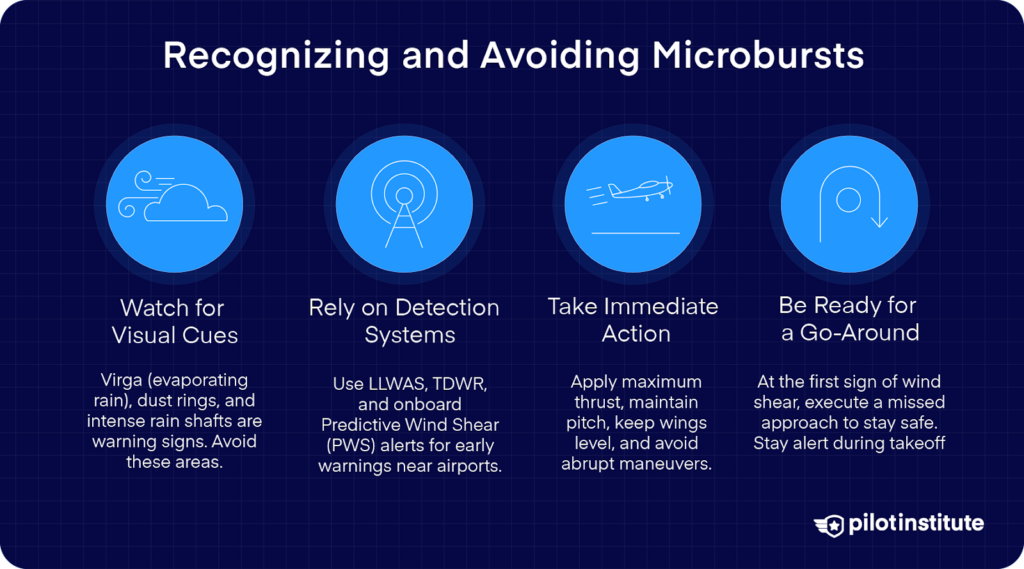
- Virga: When you see precipitation that evaporates before reaching the ground, take that as a huge red flag. You should especially be alert in arid regions because it’s often a sign that a dry microburst is forming below the cloud. If you see virga ahead, it’s best to steer clear. There could be a violent wind shear just waiting below.
- Dust Rings or Blowing Dust: According to the FAA, when there is little or no precipitation at the surface accompanying the microburst, a ring of blowing dust may be your only visual clue. If you notice dust kicking up unexpectedly, chances are there’s a microburst in the area. Take action immediately and steer clear of the hazard.
- Intense Rain Shafts: If you’re approaching an airport and spot a rain shaft nearby, stay vigilant. A wet microburst could be just moments away from forming. It’s a good idea to fly away from the rain shaft to avoid sudden and severe wind shifts.
The bottom line? Always scan for these signs when flying near thunderstorms, especially during takeoff and landing. Your situational awareness will save you from a nasty, unexpected wind shear.
Microburst Detection Systems
Visual clues are reliable, but technology can help detect microbursts before they become a real and serious threat.
The Low-Level Wind Shear Alert System uses a network of anemometers placed around airports to detect sudden wind shifts.
If dangerous wind shear is detected, the LLWAS will display the hazard to air traffic controllers (ATCs), who will relay the warning to all pilots at the relevant frequencies.
The Terminal Doppler Weather Radar is designed specifically to detect microbursts and wind shear near airports. It identifies and warns ATCs of low-altitude wind shear hazards caused by microbursts and gust fronts.
The TDWR also reports on precipitation intensities and advanced warnings of wind shifts. It provides real-time data to enhance safety during takeoff and landing.
Airborne Weather Radar can be helpful in detecting storm activity, but traditional radars have limitations when it comes to microbursts since they’re very small in scale.
Some modern aircraft are now also equipped with onboard Predictive Wind Shear Alert Systems (PWS) that can detect microbursts ahead and issue alerts.
Training for Microburst Encounters
Once you are inside a microburst, there may be nothing you can do to prevent an accident if the forces are strong enough.
That’s why the best course of action is not to put yourself in the position to be inside of a microburst. Proper weather briefings and training are your best defense. When you recognize the early warning signs, take action quickly to avoid the possibility of a microburst.
But let’s say you’ve done your very best to avoid it but still end up caught in one. What do you do? Calm down and follow these steps:
- Apply maximum thrust immediately. Your top priority is to regain and maintain airspeed.
- Maintain pitch attitude based on wind shear escape guidance. Don’t lower the nose!
- Avoid abrupt maneuvers. Keep wings level to prevent unnecessary drag or instability.
- Be ready for a go-around. The FAA advises pilots to initiate a missed approach at the first sign of a microburst.
The FAA emphasizes that you should be alert for microburst indications early in the approach phase and be ready to initiate a missed approach at the first sign of trouble.
Simulate wind shear training and keep practicing. You should always be prepared to fly away from these dangerous forces.
Conclusion
Microbursts can be scary, dangerous, and even deadly. They produce intense downdrafts and severe wind shear that can be nearly impossible to escape. They’re small and sudden, which makes them especially tough to detect.
But remember that your first—and perhaps only—line of defense will be your awareness and training.
Even with technological advancements like TDWR and LLWAS, nothing can replace pilot vigilance. Stay updated with the latest training and technology, and continue to educate yourself on weather hazards.
Aviation safety depends on preparedness and awareness. Technology helps, but the ultimate responsibility lies with you. Stay safe out there, and stay prepared.