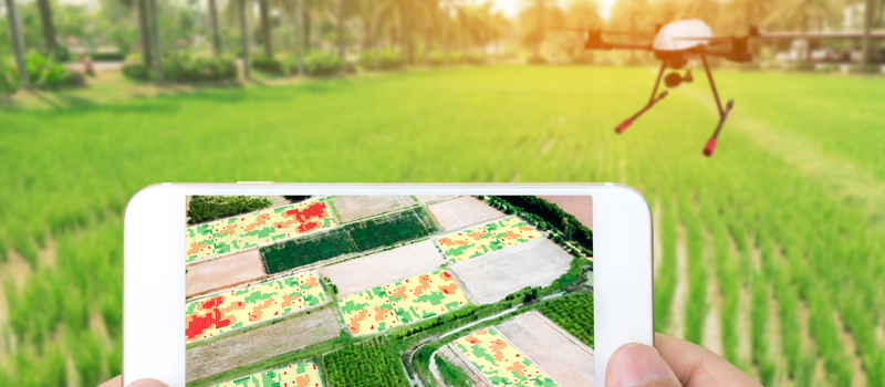
Aerial mapping is a field that is particularly well-suited for drone use. Compared to having to fly a helicopter to record remote data, a drone can do the same job faster, more accurately, and in a safer manner. These factors have made drone mapping one of the most lucrative avenues for professional drone pilots.
However, it takes more than just a drone and an onboard sensor to successfully undertake a mapping campaign. You will need software to help you plan the survey, execute it, and process the resulting data. The most convenient way to do all these is through a software package that offers all the necessary features. In this article, we list down the best drone mapping software packages available today.
What to look for in drone mapping software
Drone mapping is a technically demanding field that usually attracts drone pilots who already have experience with remote sensing or 3D modeling. However, even skilled drone pilots seek out the convenience and quality of life improvements that a good drone mapping software package can offer. With such a lucrative industry to cater to, the market for drone mapping software has proven to be just as competitive.
With so many options, how can you pick the right one? Here are some of the major factors to consider:
1. End-to-end services
The most important thing to look for in a drone software package is that it offers all the necessary solutions to carry out a mapping survey. This includes features that can help you plan the scope and flight path of the survey, communicate with the drone to execute the survey autonomously, record the data and save it to cloud or local storage, process the data, and generate a good selection of different models.
Working within a single platform is a massive quality of life improvement that will streamline your process and shorten your turnaround time. The most popular drone software packages offer this feature so there’s no reason for you to settle for something less.
2. Compatible file formats
As a professional drone pilot offering mapping services, you will have to provide deliverables to your clients using the format that they need. Your clients may need to open your data or model using other industry-standard software AutoCAD, ArcGIS, or Google Earth. These clients may have different standards, so it’s important that your mapping software package can export files in a wide variety of different file formats.
3. Customer support
Customer support doesn’t just pertain to the assistance that the software developer will provide to you if something goes wrong, although that’s an important part of it. It should also cover regular software updates to keep the platform up to date and a comprehensive set of tutorials that will teach you everything from the basics of the software to the most advanced functions. Regular updates are particularly important if you want your mapping capabilities to always be keeping up with the newest industry standards.
4. Ease of use
If you’re primarily a professional drone pilot with just a side-gig of being a drone mapper, then you might not have the technological savvy nor a lot of time to learn a new mapping software platform. Of course, ease of use may not be much of a priority for seasoned professionals who have done remote sensing or mapping before. However, if you’re still new to the field, then you might want to stick to options with more beginner-friendly options.
5. Price
Price can be a complex topic when we’re discussing software. Unlike the olden times when you can just buy any software with a one-time fee, most software platforms nowadays come in subscription packages. Mapping software platforms are no exception. The pricing model if set up this way because the software is treated as a “software as a service” since it provides cloud storage, processing, and regular updates.
For more conservative buyers, some software packages offer a free trial period. If you have never done aerial mapping before,
The top 5 best drone mapping software packages
1. Pix4D
When it comes to offering a comprehensive suite of solutions, the super-popular Pix4D is hard to beat. It has been in the industry for over ten years, is widely used by thousands of mapping professionals, and has a well-developed community of users and developers. Over the years, the library of Pix4D has greatly expanded to include software modules that have been specially designed for specific mapping applications.
Do you need a module for precision agriculture? Try Pix4Dfields. If you need rapid mapping for emergency response, then Pix4Dreact has you covered.
The beauty of Pix4D’s vast suite of modules is that they provide just about any service that you will need. Pix4Dcapture is a mobile complement of the platform that allows for quick survey planning and control using just your phone. The processing of data for photogrammetry and model building is handled by another module. Pix4D also exports the output files in a large selection of file formats, including widely used and industry-standard options.
Pix4D was originally designed for use with the eBee line of fixed-wing drones but have since expanded their capabilities to interface with the line of professional-grade drones from DJI.
The biggest downside of Pix4D is that it may prove to be a bit too complex for beginners. Many users have given feedback that the interface of Pix4D is not as intuitive as they had hoped and that there’s a significant learning curve to overcome before they can get anything done.
2. DroneDeploy
In contrast to Pix4D, DroneDeploy has made efforts in the last couple of iterations of their software to make it more user-friendly and accessible. The efforts seem to have paid off, as DroneDeploy now stands as one of the most popular drone mapping software platforms. DroneDeploy has focused on developing compatibility with DJI drones in its early years but has since expanded its scope to other popular drone brands.
Instead of creating a library of their own software modules, DroneDeploy extends its capabilities by providing compatibility with third-party apps. These apps, such as EZ3D and Birds.io, greatly augment what DroneDeploy can do and allow for the same dataset to be processed using different algorithms for different objectives.
The major complaint that users have with DroneDeploy is that it doesn’t offer a wide enough range of file format options for export. This could be enough to turn away professional drone mappers who need enterprise-level features. However, DroneDeploy remains uniquely suited to beginners because of an intuitive interface and easy to learn characteristics.
Another thing that will appeal to beginners is the fact that DroneDeploy offers a 30-day free trial for their mapping software. If you’re satisfied with the experience, you can choose from three subscription options, which should be enough to accommodate any budget.
3. PrecisionHawk
The PrecisionHawk family of modules is quite limited when compared to the expansive Pix4D and DroneDeploy libraries. However, what little they offer is enough to complete a standard aerial mapping job. It’s far from the best when it comes to user experience and accessibility, so we recommend trying out the free 3D map generation capabilities first.
PrecisionHawk divides the mapping process into three steps, each one catered to by a specific software module. The first step, planning, and execution, is done via the PrecisionFlight mobile app. Just like any high-quality flight planning app, PrecisionFlight allows you to quickly define a scope for the aerial survey or set a custom flight path for the drone to follow. The drone also carries out these orders automatically via the connection with the PrecisionFlight app.
Data processing is handled by the PrecisionMapper module. It is a cloud-based data processing platform where users can pick from a large and still growing library of different processing algorithms.
PrecisionMapper has been quite impressive in this aspect, as it has shaped up over the years to cover just about anything you need for aerial mapping. Whether you need a standard 3D topographic map, an orthomosaic, or a map with integrated crop health analysis, PrecisionMapper should have an algorithm for you.
Any output or raw data can be viewed via the PrecisionViewer desktop app. This is a basic viewing app that also allows for custom annotation.
While PrecisionHawk isn’t a mapping software that we can consider for beginners, they offer their cloud-based data processing capabilities for free. If you have raw survey data, you can try using free feature just to see what PrecisionHawk has in store for you.
4. AgiSoft
AgiSoft doesn’t’ offer end-to-end solutions, simply because it was designed only for processing photogrammetry data. While it does not have a complimentary flight planning mobile app, it does really well in what it was designed for – post-processing.
The 3D modeling engine of AgiSoft can stitch together virtually all types of panoramic images to create 3D models. It can process high-resolution photos, photos with fish-eye distortion, thermal images, near-IR images, and multispectral imagery. It also has a lot of output options and can create just about any model possible from aerial mapping data including orthomosaics, crop health analysis, and digital elevation models among others.
More coding-inclined users have an option to integrate a Python script with AgiSoft so you can automate repetitive tasks. This can be a really useful option if you need to process several datasets quickly.
The interface of AgiSoft is very clunky and does not hide the fact that it was definitely not designed for beginners. If you just want to try it out, then you can sign up for the 30-day free trial period. After the trial, you can proceed to pay for either the Standard or Professional subscription plans.
AgiSoft may not enjoy the level of mass appeal that other more popular drone software packages already experience. It does not have integrated flight planning, and it has a steep learning curve. However, if you’re looking for a superior post-processing option, then AgiSoft should be worth consideration.
5. DJI GroundStation
DJI GroundStation doesn’t exactly fit the bill if we’re talking about mapping software packages. Just like AgiSoft, DJI GroundStation has a singular function. In this particular case, it is only a flight planning app that works seamlessly with DJI drones. It’s one of the best flight planning apps we’ve seen, though, so it’s worth a mention.
As you would expect from the DJI brand, the interface of the GroundStation looks great and is very intuitive. If you’ve ever flown a DJI drone before (and you should have, otherwise there’s really no reason to get this app), then you will feel right at home with the controls of the GroundStation. The mission planner allows you to set an area for the survey or draw a flight path for the drone with a cap of 99 waypoints.
Another compelling reason to at least give the GroundStation a try is that it’s free to download. If you own any of the professional-grade DJI drones like any model from the Phantom or Inspire lines, then the GroundStation app would be a good place to learn how to do drone mapping surveys. It’s still quite limited in its capabilities, so we don’t be surprised if you find yourself upgrading to more robust software packages before long.
Final thoughts
Drone mapping is a very attractive option for professional drone pilots who want to earn the big bucks, but it’s also a field that requires an arsenal of skills, equipment, and software. When it comes to the hardware, any high-quality camera drone will work well enough for a photogrammetry-based mapping survey. However, the skills and software are entirely different but intrinsically related aspects.
Good mapping software will serve to highlight your skills as a professional drone mapper. You need to look for a solution that will make your process easier and reduce the work that you have to do, thus allowing you to deliver the output to your clients faster. However, even with all the shortcuts that you can take with good software, you should not forget the fundamentals of remote sensing, map projections, and 3D modeling.