-
Key Takeaways
-
What are Airport Codes?
- The History of Airport Codes
- Why Not Use Airport Names Instead?
-
What are ICAO Codes?
-
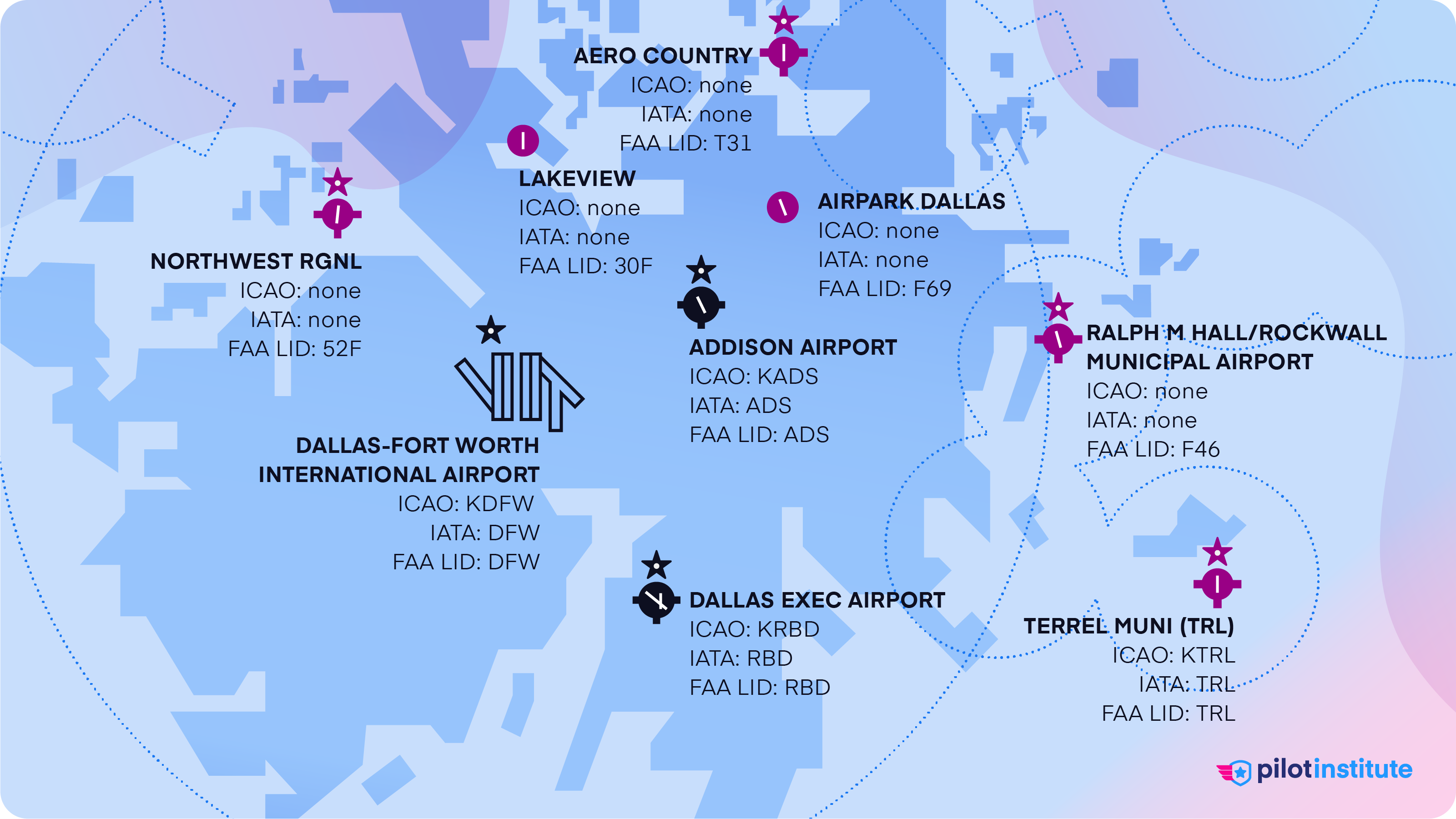
Airport Codes in the United States (FAA LID)
-
What are IATA Codes?
-
How to Use Airport Codes (As a Pilot)
- How to Identify ICAO, IATA, and FAA Codes
- What If the Airfield Has No Codes?
-
Conclusion
IATA. ICAO. FAA. All of these organizations have their own set of airport codes.
If you use the wrong one (or don’t know how they work), you risk flying to an unexpected destination and causing a massive headache for your passengers and Air Traffic Control (ATC).
So, which should you use, and how do they work?
In this article, we’ll explain everything you need to know about airport codes as a pilot.
Let’s make sure you get to the right destination.
Key Takeaways
- ICAO, IATA, and FAA LIDs all identify airports according to their specific roles.
- ICAO codes are concise yet unambiguous for pilots and ATC.
- IATA codes are easier and more intuitive for passengers and shippers.
- FAA LIDs are only valid for the United States but include small airfields that have no other codes.
- Pilots using codes to file flight plans and navigate must ensure they pick the right ones.
What are Airport Codes?
Airport codes come in three main types: ICAO, IATA, and FAA LIDs, each serving a specific purpose.
ICAO codes, assigned by the International Civil Aviation Organization, are four-letter codes. They’re used globally in flight operations and Air Traffic Control.
The International Air Transport Association issues IATA codes. These are the three-letter airport codes travelers are most familiar with. Flight ticketing, baggage handling, and cargo shipping primarily use these codes.
Lastly, the Federal Aviation Administration (FAA) assigns Location Identifiers (LIDs) to airports within the United States. LIDs are three or four letters long and are only involved in domestic flight operations.
Every airport receives an assignment of one, two, or even all three codes. Small and remote airstrips may have no code at all!
The History of Airport Codes
In the early days of aviation, communications networks had to use Morse code via radio. This method only allowed the sending of one letter at a time. Transmitting long airport names would have been very inefficient. Instead, pilots used two-letter weather station codes to identify nearby airports.
Two-letter codes only allow for 670 unique codes, which started to run out as the aviation industry grew. In 1947, ICAO launched its four-letter coding system and developed it globally. IATA established its own three-letter system around the same time.
The FAA took over the existing two-letter system in the US in 1958 and expanded it to three-character Location IDs.
Why Not Use Airport Names Instead?
Codes are much shorter than most airport names. It’s much easier to use the code “JFK” than the name “John F Kennedy International Airport.”
Using standard codes also overcomes language barriers and difficulties with complex airport names. They also prevent mix-ups between airports that share the same name.
Using a code also offers stability and consistency when airports and even cities change names over time.
What are ICAO Codes?
ICAO airport codes are always four letters. Pilots, ATC, and aviation authorities use these codes.
This standard format lets tools like navigation charts, GPS systems, and weather reports work together. The codes also help reduce errors and misunderstandings in critical data for flight operations.
The four letters in ICAO codes allow more than 450,000 unique combinations!
The actual number of possible codes is far fewer since the codes are subject to some rules. For example, airport codes cannot begin with I or J as ICAO reserves them for identifying Navigational Aids.
While the exact number of active ICAO codes isn’t known, there are at least 46,000 airfields assigned ICAO codes. These codes are never reused, so the number includes airfields that have since closed.
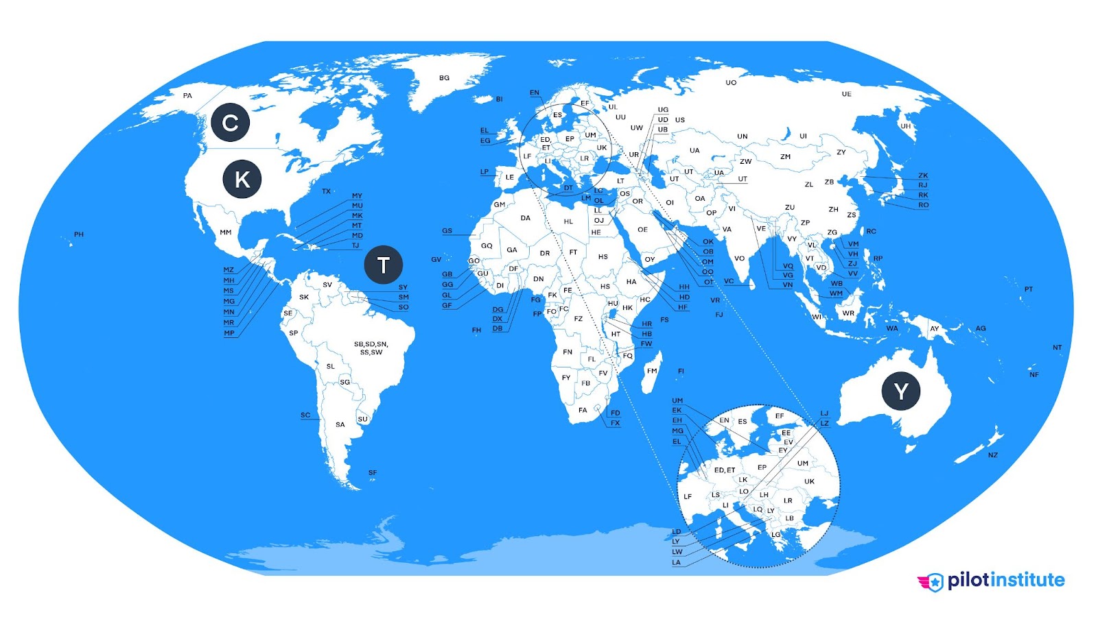
The first letter of the ICAO code denotes the general geographic region of the airport. These include E for Northern Europe, S for South America, and C for Canada.
Countries that have territories in multiple regions are usually assigned several letters. Even the United States uses more than one code. Mainland US states use K, but since Hawaii and Alaska lie in the Pacific region, their codes start with P.
The second letter narrows it down to the country. But not every country uses a specific second letter. Some larger countries, such as Russia, China, Brazil, and Indonesia, use different second letters depending on the region in the country.
The United States does this, too. The US uses PH, PA, and PG for Hawaii, Alaska, and Guam, respectively. Puerto Rico and the Virgin Islands have TJ and TI since they are part of the Caribbean.
The last two letters identify specific airports. They usually relate to the city’s name. For example, the airport in Cape Town, South Africa, uses FACT for its code. FA is South Africa’s code, with CT standing for Cape Town.
Cities with multiple airports use codes that reference the airport’s name instead. Some codes are assigned for historical reasons. For example, Canadian airport codes originate from their weather reporting station designations.
Airport Codes in the United States (FAA LID)
The FAA developed its own system for naming airports, which works in parallel with ICAO codes. The FAA’s Location IDs use three-character alphanumerics, meaning they can use numbers as well as letters.
Every registered airport in the United States has an FAA LID. The LID is the same as ICAO’s assigned code for most large airports – with the leading K removed. So KSFO becomes SFO, KLGA gets LGA, and so on.
The US does have some local restrictions on some letters. LIDs aren’t supposed to start with the letters K, N, Q, W, Y, and Z.
K and W are reserved for public radio stations, while the letter Q is used in Morse radio codes called Q-codes. N is used for Naval Air Bases, and Z designates Air Route Traffic Control Centers (ARTCCs). To avoid confusion, the letter Y is not used as it overlaps with internal codes for Canadian airports designated by Transport Canada.
Despite these rules, the FAA occasionally assigns LIDs starting with these letters anyway. An example is New Orleans Lakefront Airport which has NEW as its code.
The FAA only assigns an all-letter code to airports with a 5,000-foot or longer runway and an advanced weather station.
Smaller public-use airports have LIDs with one letter and two numbers.
Small private-use airfields are a special case. They get two letters and two numbers, making up a four-character LID. There’s no chance of mixing these up with four-letter ICAO codes, as ICAO doesn’t use numbers in their airport codes.
What are IATA Codes?
IATA airport codes only use three letters, which allows up to 17,500 possible codes. That’s significantly less than the number of airports in the world. Even so, the IATA code list is far from full.
Why?
Only airports with regular scheduled passenger and cargo service get an IATA code. General aviation airports don’t use IATA codes since they don’t sell tickets or need baggage handling.
Unlike ICAO codes, individual letters in IATA codes don’t give any geographic information. They are, however, more intuitive as they don’t need to follow ICAO’s regional rules.
For example, you would need to look up VHHH, YSSY, and EIDW to know their assigned airport. But their IATA counterparts – HGK, SYD, and DUB are easily recognizable as representing Hong Kong, Sydney, and Dublin.
IATA offers access to their database of airport codes here. The database includes airport area codes as well.
What are airport area codes?
Large metropolitan areas with multiple airports also get their own IATA code in addition to an individual code for each airport. For example, New York City’s airports, Newark, Kennedy, and LaGuardia, use EWR, JFK, and LGA. The New York metropolitan area as a whole has the code NYC.
IATA focuses on passenger ticketing and booking cargo, so they use airport area codes to simplify flight searches to multiple airports serving the same city.
Wouldn’t it be easier just to use proper city names instead?
Well, no, because many cities worldwide have names that are duplicates of more famous cities. For example, London, Ontario, and Birmingham, Alabama, have well-known counterparts in the United Kingdom. The states of Arkansas, Idaho, Illinois, Tennessee, and Texas have at least one Paris each!
You can use the IATA code to verify that you’ve selected the correct airport when booking a flight. For example, Birmingham, Alabama, uses BHM, but if you’re going to Birmingham, UK, the code you need is BHX.
Double-check your destination with the IATA code to ensure you’ve picked the right one.
Even with this system in place, mistakes still happen.
People somewhat routinely book tickets to Sydney, Canada (YQY) while trying to travel to Sydney, Australia (SYD), for example. Checking the IATA code is especially crucial for online bookings, where there are no travel agents involved who can notice the error.
IATA codes that don’t match the city’s name usually have a fascinating reason behind the odd naming. For example, Orlando International is MCO because the airfield used to be called McCoy Air Force Base.
IATA codes for some cities are so commonly known that they’re even part of casual conversation among people. Many Canadians know that YYC refers to Calgary and that YVR is Vancouver, even without knowing the history behind those codes.
How to Use Airport Codes (As a Pilot)
Pilots don’t need memorable codes but must ensure they choose the right airport. This makes ICAO codes the best option because of their organized naming scheme.
As a pilot, ICAO codes will be the codes you work with the most. They are always used for international flights as well as those flown under Instrument Flight Rules (IFR).
If you’re flying domestically within the United States, especially under Visual Flight Rules (VFR), you can use the FAA Location Identifier alternatively.
The FAA adopted the ICAO flight plan format in 2019. That means that you’ll use ICAO codes for flight planning. But FAA flight plans still accept LIDs, especially for small airfields and private airstrips that don’t have ICAO codes yet. Flight planning software and tools often automatically convert LIDs to their ICAO equivalents if they’re available.
You’ll use these codes while preparing your flight plan and looking up charts and facility information for your route.
Use the FAA’s search tool to look up the FAA ID for an airport or identify which airport an ID belongs to.
How to Identify ICAO, IATA, and FAA Codes
The first clue is the length of the code. A three-letter code cannot be an ICAO airport code.
The next step is to see if the code contains any numbers. IATA codes only consist of letters, so the presence of numbers makes it evident that the code belongs to a small US airfield.
If you’ve only got three letters in the code, it’s probably an FAA LID or an IATA code. Many LIDs are the same as their corresponding IATA codes, but there are exceptions. In this case, searching in the FAA database will give you the answer.
What If the Airfield Has No Codes?
The United States has over 5,000 public-use airports and over 14,000 private airfields. All major airports have ICAO, IATA, and LID codes. Airports without scheduled passenger and cargo traffic don’t get IATA codes.
Most smaller airports have either an ICAO code, a LID, or both. The smallest and most remote airstrips may have no code assigned to them at all. These are usually simple fields or short runways on private property. Sometimes, they’re only temporary – for crop dusting or ultralight flying.
If the airfield doesn’t have an FAA LID code, input the nearest available airport code while filing your flight plan. Note the actual destination in the Remarks section of the flight plan.
You can also use the larger airport as a reference to coordinate with Air Traffic Control. Helicopters often do this when landing at a temporary landing site or on private property.
Use GPS coordinates to navigate to the airfield. Many aircraft GPS systems allow pilots to enter specific latitude and longitude coordinates. Sectional and VFR charts often show small airstrips, even inactive ones. If it’s not on the chart, navigate by looking at visual landmarks in the vicinity.
Conclusion
Airport codes can seem complex, but we do ask a lot from them. They have to be simple enough for people to use but still uniquely identify thousands of airports worldwide.
With multiple standards running in parallel and frequently overlapping, some confusion is inevitable.
Even so, the system works well enough that you can expect to arrive exactly where you intended when you get on your next flight.