
-
Key Takeaways
-
What Is the Difference Between a G-AIRMET and a SIGMET?
-
What Is an AIRMET?
- 2025 AIRMET Change (What’s New)
- What Is a G-AIRMET?
- G-AIRMET Hazard Groups
-
What Is a SIGMET?
-
Where to Find G-AIRMETs and SIGMETs
-
How to Read a SIGMET
- SIGMET Abbreviations
-
SIGMET Structure: Header, Summary, and Main Body
- The Header Section
- The Summary Section
- The Body Section
-
SIGMET Renewal or Cancellations
-
Conclusion
For pilots and anyone involved in aviation, understanding AIRMETs and SIGMETs is invaluable.
These weather alerts each have their own role:
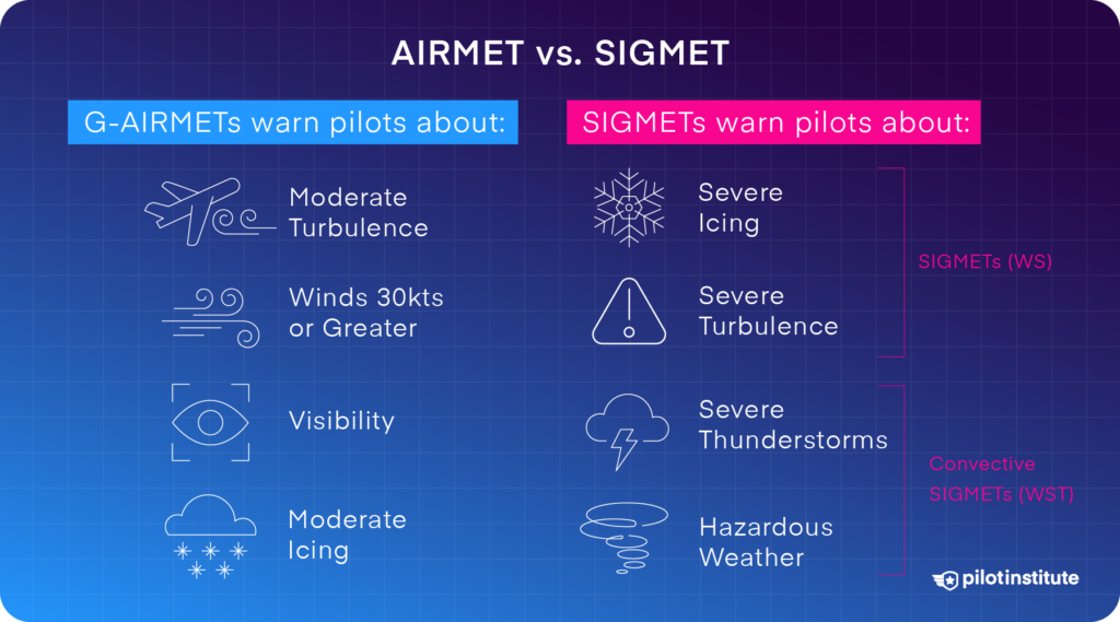
G-AIRMETs warn about moderate conditions like turbulence, icing, and limited visibility, which can affect smaller or less equipped aircraft.
SIGMETs alert pilots to more severe weather events like thunderstorms, volcanic ash, or strong turbulence that could pose serious risks to any flight.
But do you know how to read them?
In this article, we’ll discuss what makes AIRMETs and SIGMETs important, how to read them, and why each matters for flight planning. Stick with this article til the end, and you’ll know how you can use them to make smarter decisions.
Key Takeaways
- AIRMETs warn of moderate weather like turbulence and icing.
- SIGMETs alert pilots to severe weather, such as thunderstorms.
- G-AIRMETs are updated every 3 hours; SIGMETs are issued as needed for 4 hours.
- Find AIRMETs and SIGMETs with the Aviation Weather Center.
Private Pilot
Study Sheet

Grab a printable PDF that highlights must-know PPL topics for the written test and checkride.
- Airspace at-a-glance.
- Key regs & V-speeds.
- Weather quick cues.
- Pattern and radio calls.
What Is the Difference Between a G-AIRMET and a SIGMET?
AIRMET and SIGMET weather advisories are issued to warn pilots of potentially hazardous weather conditions they might encounter while flying.
AIRMETs consist of turbulence, visibility, and icing-related warnings that are less severe than those in a SIGMET.
A SIGMET includes thunderstorms, volcanic ash, dust storms, as well as other weather (described below), and is more severe overall.
G-AIRMETs are updated every 3 hours and provide hazard forecasts out to 12 hours ahead. SIGMETs are issued as needed and are usually valid for up to 4 hours (sometimes up to 6 hours for volcanic ash or hurricanes).
What Is an AIRMET?
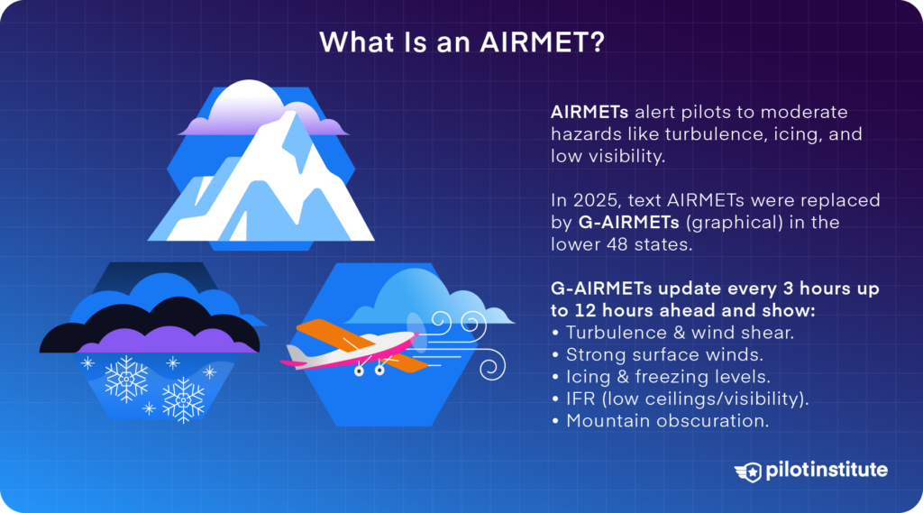
An AIRMET is a weather advisory for pilots that alerts them to potential hazards in the air. The acronym “AIRMET” stands for “Airmen’s Meteorological Information.”
2025 AIRMET Change (What’s New)
The traditional alphanumeric (“TAC”) AIRMET text bulletins, which are Sierra/Tango/Zulu by region, were retired for the CONUS on Jan 27, 2025.
G-AIRMET continues as the operational product. (Alaska/Hawaii TAC AIRMETs were not affected by this change.)
What Is a G-AIRMET?
A G-AIRMET (Graphical Airmen’s Meteorological Information) is an NWS advisory for widespread moderate hazards that are less severe than a SIGMET.
G-AIRMET is issued as time-slice graphics and is updated every 3 hours, up to 12 hours ahead. You can view these on the AWC Graphical Forecasts for Aviation (GFA).
G-AIRMET Hazard Groups
Pilots used to refer to these groups as Sierra, Tango, and Zulu, but the GFA now presents them by weather type.
G-AIRMET hazards include:
- Turbulence: Moderate, non-convective turbulence and its vertical extent.
- Low-Level Wind Shear (LLWS): Wind shear below 2,000 ft AGL (20+ kt gain/loss).
- Strong Surface Winds: Sustained winds over 30 knots.
- Icing: Moderate, non-convective airframe icing.
- Freezing Levels: Lowest freezing level above ground or surface.
- IFR: Ceilings below 1,000 ft AGL and/or visibility under 3 miles.
Mountain Obscuration: Widespread areas where terrain is obscured.
What Is a SIGMET?
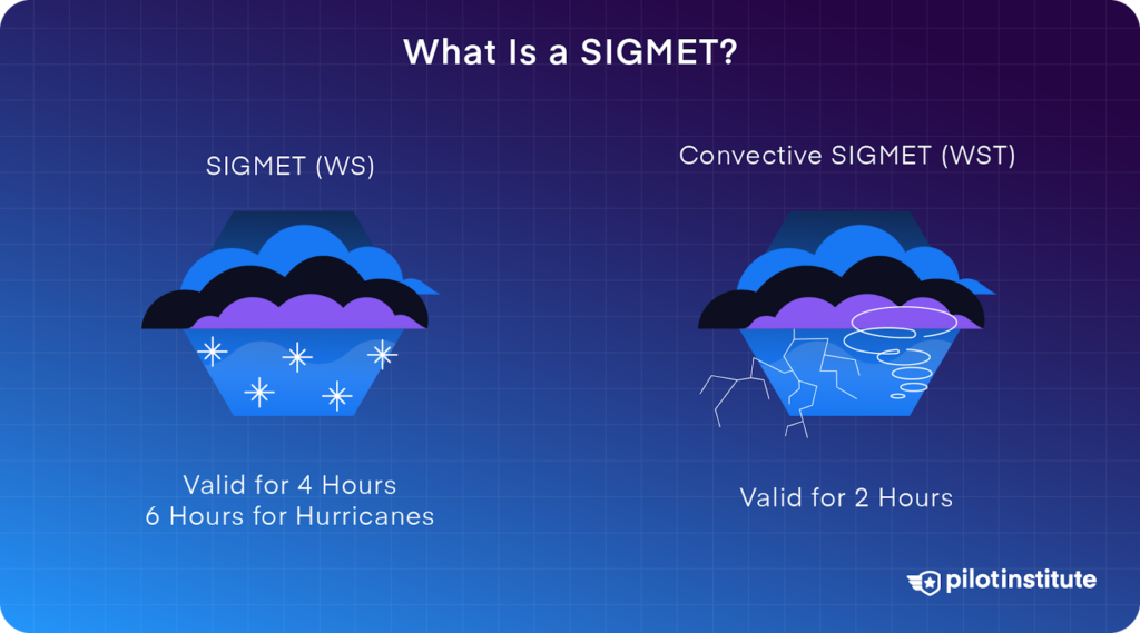
A SIGMET (Significant Meteorological Information), denoted by WS, is a U.S.-specific weather advisory. It alerts pilots to potentially hazardous non-convective weather conditions.
These advisories are usually valid for four hours. The exception is when SIGMETs are issued for volcanic ash and hurricanes in oceanic regions outside the contiguous U.S. (CONUS). In that kind of situation, they are valid for six-hours.
SIGMETs (WS) are issued when the following phenomena occur or are expected to occur:
- Severe icing not associated with thunderstorms.
- Severe or extreme turbulence or clear air turbulence (CAT) not associated with thunderstorms.
- Widespread dust storms or sandstorms lowering surface or inflight visibilities to below 3 miles.
- Volcanic ash.
Convective SIGMETs (denoted WST) specifically address severe convective activity and are issued in the U.S. for any of the following:
- Severe thunderstorm due to:
- Surface winds greater than or equal to 50 knots.
- Hail at the surface greater than or equal to ¾ inch in diameter.
- Tornadoes.
- Embedded or severe thunderstorms expected to persist for over 30 minutes.
- Lines of thunderstorms: At least 60 miles long, with storms affecting at least 40% of the Convective SIGMET area.
- Thunderstorms producing heavy or greater precipitation affecting 40 percent or more of an area at least 3,000 square miles.
Convective SIGMETs are issued hourly and valid for two hours within three designated U.S. regions: Eastern, Central, and Western.
They are updated as needed, particularly if severe weather persists or intensifies.
Both SIGMETs and Convective SIGMETs are broadcast via ATIS, ATC, and other aviation communication channels.
Each advisory is assigned an alphabetic designator from N through Y (excluding S and T) to help pilots anticipate dangerous weather and take necessary precautions.
Where to Find G-AIRMETs and SIGMETs
You can find G-AIRMETs and SIGMETs from the Aviation Weather Center. Their website has graphical and textural forecasts. These include turbulence, icing, and more severe weather warnings.
You can view these advisories mapped over specific regions, making it easy to adjust your route if needed.
A lot of pilots also turn to tools like ForeFlight, FltPlan or SkyVector to access G-AIRMET and SIGMET data. The advantage of these tools is you can get the data directly on your mobile device.
Using multiple resources can give you more flexibility when making decisions for flight planning.
How to Read a SIGMET

SIGMETs are similar to METARs and TAFs but use a slightly more complicated structure. Let’s take a look at it in detail.
SIGMET Abbreviations
SIGMETs use standard aviation abbreviations to provide important details quickly. Here are some common abbreviations used in SIGMETs:
- ABV: Above
- OBS: Observed
- FCST: Forecast
- FIR: Flight Information Region
- MOV: Moving
- NC: No Change
- STNR: Stationary
- WKN: Weakening
- INTSF: Intensify
- KT: Knots
- NM: Nautical Miles
- Z: Zulu time (UTC)
SIGMET Structure: Header, Summary, and Main Body
This structure is divided into three sections:
- Header
- Summary
- Main Body
The Header Section
The header identifies the type and origin of the SIGMET. It follows this format:
TTAAii CCCC YYGGgg [CCx]
Where:
- TT: Indicates the type of weather (e.g., “WS” for non-convective SIGMETs).
- AA: The country or territory code.
- ii: Bulletin number, indicating the number of SIGMETs issued for this type.
- CCCC: ICAO code for the issuing office.
- YYGGgg: Date and time of issue in UTC (Zulu time).
- [CCx]: Optional correction indicator, used if the SIGMET has been amended.
Example:
WSUS31 KKCI 061555 translates to a SIGMET issued by Kansas City for the U.S., issued on the 6th at 15:55 UTC
The Summary Section
The summary includes a brief overview of the SIGMET, providing validity, affected regions, and sequence information. Its format is:
CCCC SIGMET [n][n]n VALID YYGGgg/YYGGgg CCCC-
Where:
- CCCC: ICAO code of the affected area.
- SIGMET: Specifies if it’s a regular or convective SIGMET.
- [n][n]n: Sequence number indicating how many times the SIGMET has been renewed.
- VALID YYGGgg/YYGGgg: The period the SIGMET is active, using UTC times.
- CCCC-: Location of the issuing office.
Example:
KZNY SIGMET 1 VALID 061200/061600 KZNY- denotes that the New York Center issued the first SIGMET, valid from 12:00 to 16:00 UTC
The Body Section
The body section of a SIGMET has many variations and takes the following structure:
CCCC [FIR/CTA list] <Phenomenon> OBS/FCST [AT GGggZ] <Location> <Level> [MOV XXX xx KT/KMH] [INTSF/WKN/NC] [FCST AT <GGgg>Z <location>]=
Where:
- CCCC: ICAO region and location code.
- <Phenomenon>: Weather phenomenon, such as severe turbulence (SEV TURB) or thunderstorms (EMBD TS).
- OBS/FCST [AT GGggZ]: Specifies if the condition is observed (OBS) or forecasted (FCST) with the time in UTC.
- <Location>: Location coordinates or general area description.
- <Level>: Affected altitudes, such as FL180 (Flight Level 180).
- [MOV XXX xx KT/KMH]: Direction and speed of movement (e.g., MOV N 30 KT).
- [INTSF/WKN/NC]: Intensity changes, like intensifying (INTSF) or weakening (WKN).
Example:
EMBD TS OBS AT 061500Z 60SSE TUS MOV E 30KT TOP FL350 translates to an embedded thunderstorm observed at 15:00 UTC, 60 nautical miles southeast of Tucson, moving east at 30 knots, with a top altitude of 35,000 feet.
SIGMET Renewal or Cancellations
Suppose a SIGMET’s validity period is about to expire, but the weather phenomena are still expected to occur. In that case, a new sequence number will be added to the SIGMET, thereby renewing it.
The following will replace a SIGMET that is canceled during its validity period:
CNL SIGMET [n][n]n YYGGgg/YYGGgg
Example:
CNL SIGMET 1 061600/061800 means the first SIGMET, valid from 16:00 to 18:00 UTC, has been canceled.
Conclusion
Knowing how to read SIGMETs and AIRMETs is an important part of being a pilot. Learning more about G-AIRMETs and SIGMETs helps you make better decisions about your flight.
Your decisions could include whether to continue, change your route, or even cancel if the weather looks risky.
These advisories give you a heads-up on what’s happening in the skies along your path, like thunderstorms or heavy turbulence.
Practicing with real advisories will make the codes and terms feel much more natural. So what seems complicated at first will eventually become second nature.
Keep coming back to these tips, and soon you’ll be reading them like a pro!