-
Key Takeaways
-
What Are Fronts?
-
Warm Front
-
Cold Front
- Squall Lines
-
The Difference Between Warm and Cold Fronts
-
Stationary Front
-
Occluded Front
- Cold Front Occlusion
- Warm Front Occlusion
-
Frequently Asked Questions
- What Are the Four Types of Weather Fronts?
- What Is the Difference Between a Warm Occluded Front and a Cold Occluded Front?
- When Could a Stationary Front Become a Warm or Cold Front?
-
Conclusion
Fronts are extremely important to pilots and can significantly impact a flight.
Do you know what kind of weather each type of front provides?
In this article, we’ll explain the different types of fronts in meteorology.
Key Takeaways
- A front is a boundary between two air masses.
- Any approaching front means changes in the weather are imminent.
- The four types of fronts are warm, cold, stationary, and occluded.
- Warm fronts bring poor visibility.
- Cold fronts bring precipitation.
- Stationary fronts bring a mix of cold and warm front conditions.
- Occluded fronts can bring severe weather.
What Are Fronts?
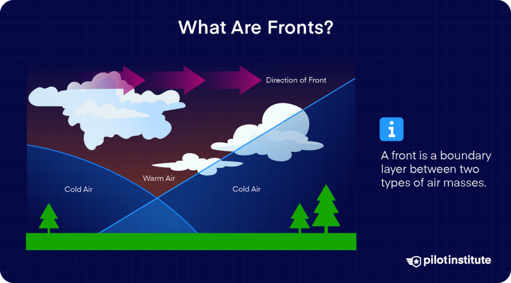
A front is a boundary between two air masses.
Air masses can control weather for a long time, from days to months.
Most weather occurs along the periphery of these air masses at boundaries called fronts.
There are four types of fronts, named according to the temperature of the advancing air relative to the temperature of the air it is replacing:
- Warm Fronts
- Cold Fronts
- Stationary Fronts
- Occluded Fronts
An approaching front of any type always means changes to the weather are imminent.
Each type of front brings its own general weather conditions; no two fronts are the same. However, generalized weather conditions associated with each type of front exist.
Let’s look at each type of front to learn what weather conditions we can expect.
Warm Front
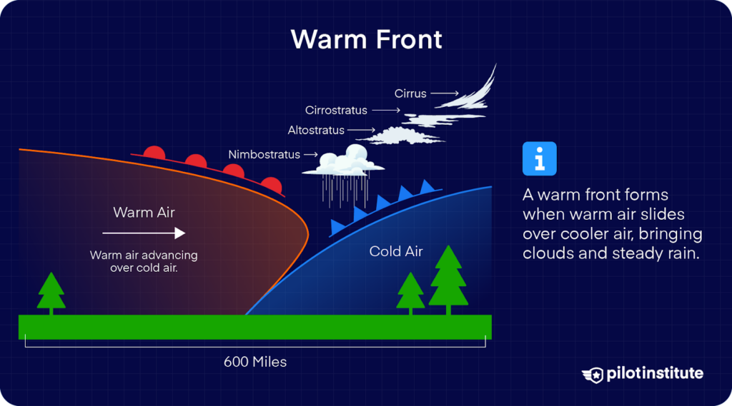
Warm fronts occur when a warm air mass advances and replaces a colder body of air, covering the colder air from the top and forcing the cold air out below.
This type of front moves slowly, typically at about 10-25 miles per hour.
Generally, as this air is forced upwards by the frontal change, stratiform and cirriform clouds and fog can be expected.
In the summer months, this lifting action can trigger cumulonimbus clouds.
Precipitation is light to moderate, accompanied by poor visibility.
During the passage of a warm front, stratiform clouds are visible, and drizzle may fall.
The visibility is generally poor but improves with variable winds. The visibility eventually improves after the passage of a warm front, but hazy conditions may exist for a short period after passage.
There is generally a slight rise in barometric pressure, followed by a decrease in barometric pressure.
Cold Front
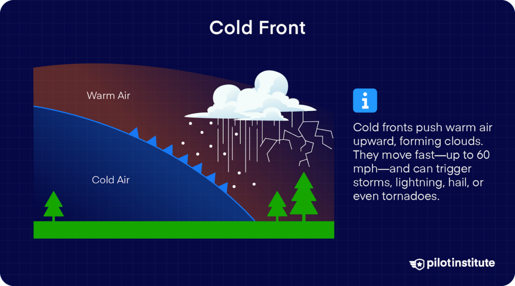
Cold fronts are the opposite of warm fronts, with colder air advancing close to the surface.
This forces the air up and away as the front moves.
Cold fronts generally move at 25-30 miles per hour, but cold fronts have been recorded at up to 60 miles per hour in extreme cases. This quick movement of warmer air upwards causes the creation of clouds as moisture condenses.
Depending on the stability of the warmer air mass, the cloud type may change.
Typically, these clouds are either towering cumulus or cirriform. However, cumulonimbus clouds may develop.
Cumulonimbus clouds can result in lightning, thunder, hail, and even tornadoes in severe cases.
After the frontal passage, towering cumulus clouds will dissipate, and precipitation will decrease. The skies clear rapidly, leaving behind gusty, turbulent winds and colder temperatures.
There is generally a fall in barometric pressure, followed by an increase in barometric pressure.
Squall Lines
When a fast-moving cold front is present, a squall line may form.
Squall lines are narrow bands of thunderstorms that form ahead of a cold front.
They are very intense and can move quickly.
A squall line’s steady-state thunderstorms present the most intense weather hazard to aircraft.
The Difference Between Warm and Cold Fronts
Warm fronts generally bring low ceilings, poor visibility, and rain.
Warm fronts occur more slowly, provide warning of the incoming front, and are generally less intense than cold fronts.
Cold fronts, however, approach with little warning and can completely change the weather in a few hours.
The weather clears rapidly after a cold front, and the weather that does occur is more intense.
Keep It on
Your Phone

Study anywhere with easy-to-skim pages and exam-style reminders.
- Bite-sized sections.
- Simple mnemonics.
- Add your notes.
- Clickable FAR links.
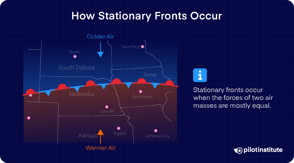
Stationary Front
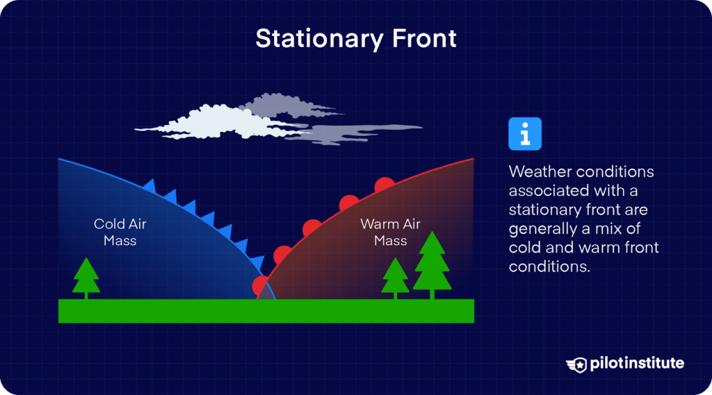
Stationary fronts occur when the forces of two air masses are relatively equal, causing the front not to move.
A stationary front can sit over an area for a prolonged amount of time.
Weather conditions associated with a stationary front vary widely, but they’re generally a mix of cold and warm front conditions.
Occluded Front
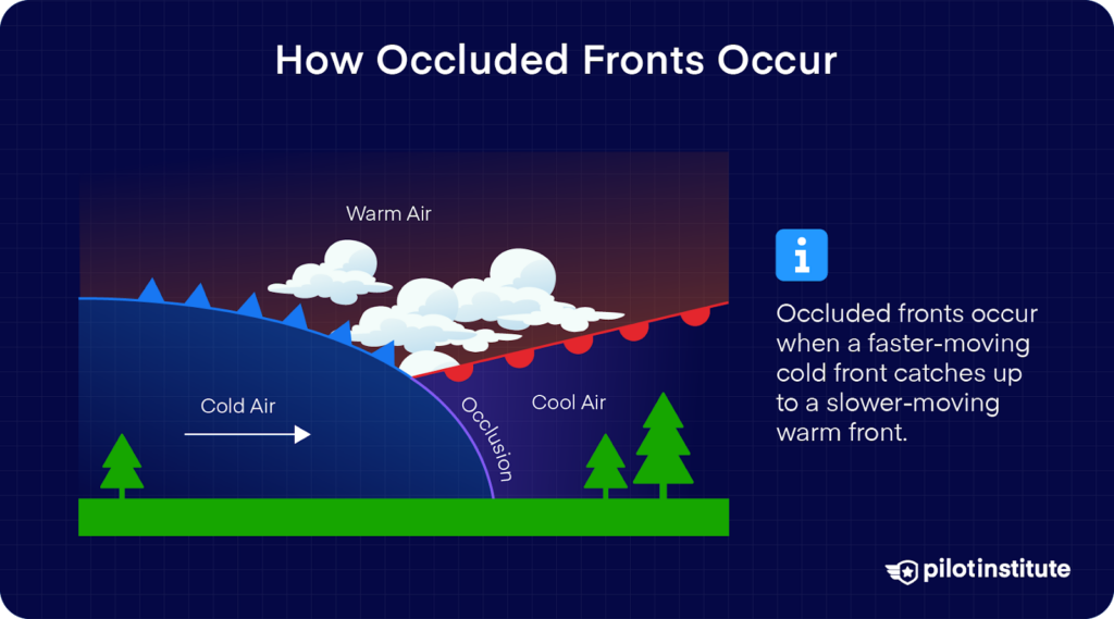
Occluded fronts occur when a faster-moving cold front catches up to a slower-moving warm front.
As the occluded front approaches, we can expect warm front weather immediately followed by cold front weather.
Occluded fronts have two variants: a cold front occlusion and a warm front occlusion.
The type depends on the temperature of the air mass ahead of both warm and cold fronts, compared to the cold front that is catching up to the warm front.
Let’s look at both variants in further detail.
Cold Front Occlusion
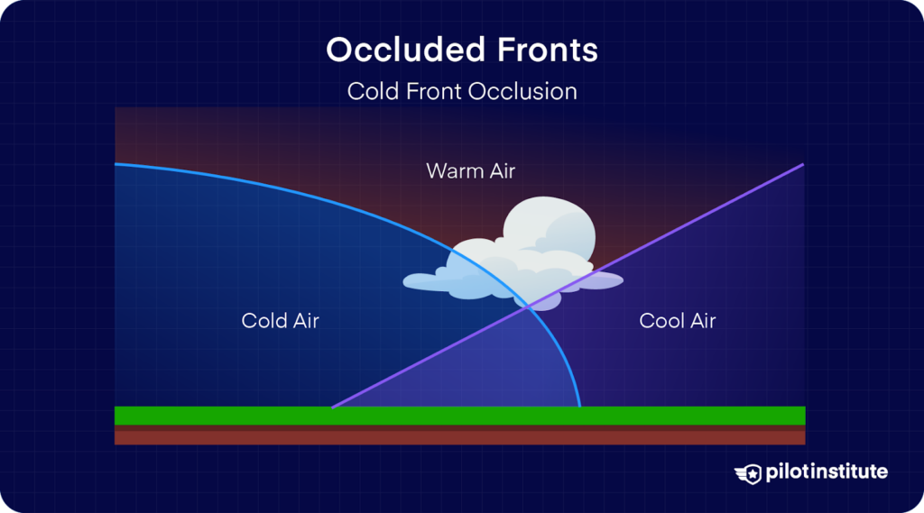
A cold front occlusion occurs when the cold front’s air mass is colder than the air mass in front of the slow-moving warm front.
The cold air replaces the cool air and forces the warm front aloft into the atmosphere.
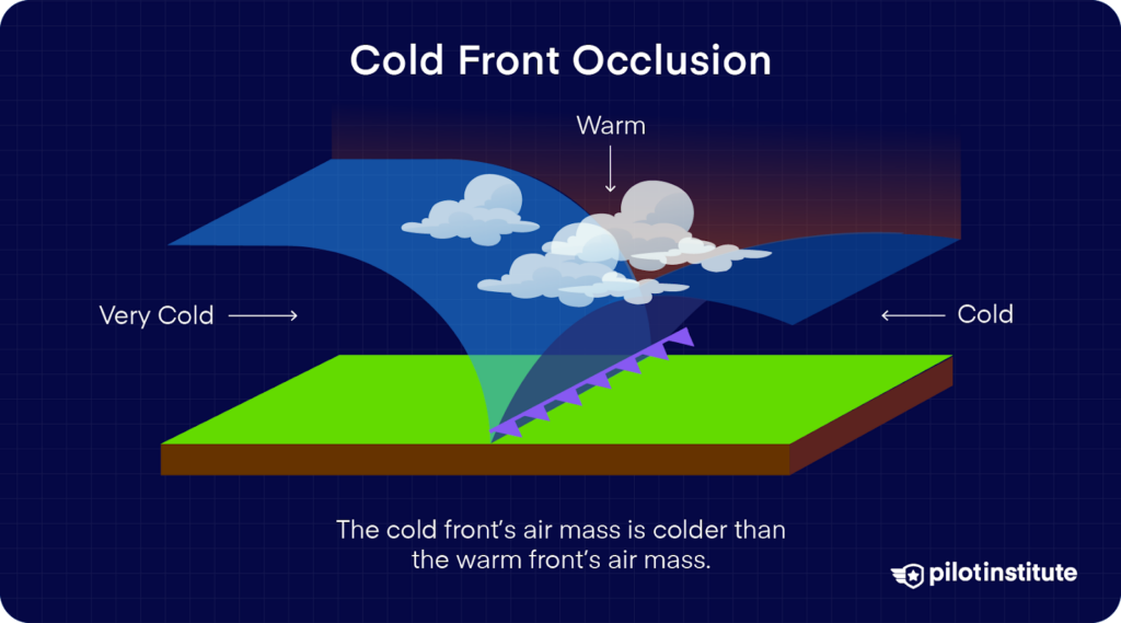
Typically, the cold front occlusion creates a mixture of weather found in both warm and cold fronts, provided the air is relatively stable.
Warm Front Occlusion
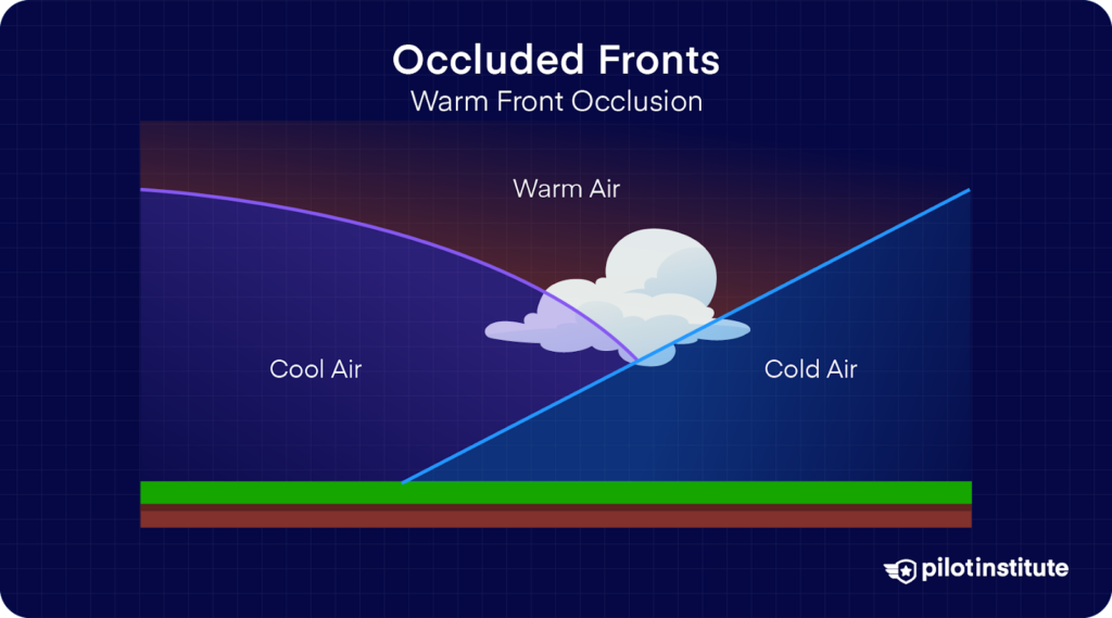
A warm front occlusion occurs when the air ahead of the warm front is colder than the air of the faster-moving cold front.
When this occurs, the cold front “rides up” and travels over the warm front’s cold air mass.
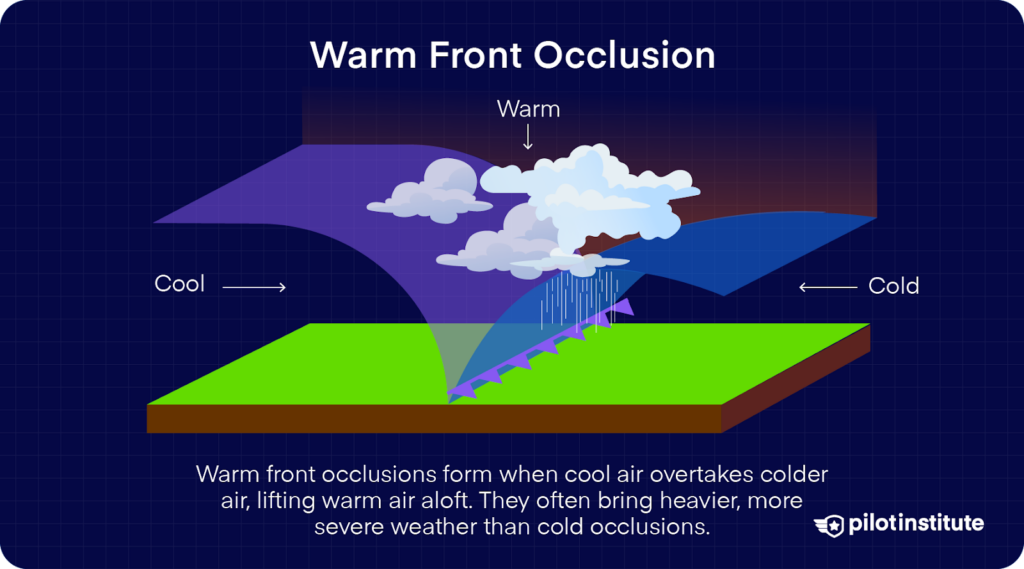
If the air forced upwards by the warm front occlusion is unstable, the weather is more severe than the weather found in a cold front occlusion. Embedded thunderstorms, rain, and fog are likely to occur.
Frequently Asked Questions
What Are the Four Types of Weather Fronts?
The four main types of weather fronts are:
- Warm Fronts
- Cold Fronts
- Stationary Fronts
- Occluded Fronts
Each type forms when different air masses meet. They bring unique weather patterns that pilots must prepare for. This can include light drizzle, poor visibility, thunderstorms, and severe turbulence.
What Is the Difference Between a Warm Occluded Front and a Cold Occluded Front?
A warm occluded front happens when the air in front of the warm front is colder than the air behind the cold front. This makes the cold front move over the colder air.
A cold occluded front forms when the air behind the cold front is colder than the air ahead of the warm front. This pushes both air masses upward. The weather in a warm occlusion tends to be more severe due to greater instability.
When Could a Stationary Front Become a Warm or Cold Front?
A stationary front can transform into a warm or cold front when one of the air masses begins to move with more force.
If the warmer air starts advancing, it becomes a warm front. If the colder air gains momentum, it becomes a cold front. This transition shifts the weather conditions and requires updated flight planning.
Conclusion
Knowing how the weather works is very important for pilots. By understanding the different fronts, you’ll make better-informed decisions during flight planning.
These decisions play a part in the PAVE checklist for your flight’s go/no-go decision.