-
Key Takeaways
-
What are Thunderstorms?
-
Types of Thunderstorms
- Single-Cell Thunderstorms
- Multi-Cell Thunderstorms
- Squall Line Thunderstorms
- Supercell Thunderstorms
-
Impact of Thunderstorms on Aviation
- Turbulence
- Wind Shear
- Lightning
- Hail
- Icing
- Heavy Precipitation
-
SIGMETs and Thunderstorms
- What Are SIGMETs?
- When Is a Thunderstorm SIGMET Released?
- Why Are SIGMETs Important?
-
How to Stay Safe: Thunderstorm Forecasts
- Use Aviation Weather Forecasts
- Safe Flight Planning Tips
- National Weather Service Resources
- Always Put Safety First
-
Conclusion
Thunderstorms vary in shape and size. Each poses unique challenges for pilots.
Some storms form and dissipate quickly. Others can stretch for hundreds of miles. They wreak havoc on the ground and in the skies.
They can range from a simple, single-cell storm to a complex supercell. You must know how these systems work for flight planning. Supercells can produce dangerous results, like tornadoes and hail.
But, we have you covered. This article will help you understand thunderstorms. We’ll also show you how to flight plan around them.
Key Takeaways
- Thunderstorms produce lightning, thunder, and heavy rain.
- Weather experts classify storms as single-cell, multi-cell, squall line, or supercell.
- Thunderstorms create turbulence, wind shear, and icing risks for aircraft.
- Pilots should use weather forecasts and SIGMETs for safe flight planning.
What are Thunderstorms?
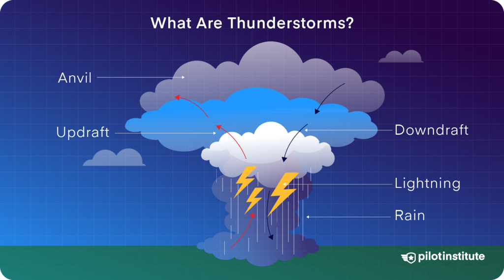
Thunderstorms are electrical local storms that deliver a punch of nature’s raw power. These atmospheric conditions typically include thunder and lightning, intense winds, excessive rain, and, at times, hail and tornadoes.
However, how do these meteorological marvels appear? The answer is simple; a thunderstorm requires three main ingredients:
- Moisture in the air.
- Unstable air (air that can rise quickly).
- Lifting movement of moist air.
When all these conditions occur, warm, moist air at the surface rises. As the air climbs, it cools and condenses, forming clouds; which rise and return to the Earth’s surface in the form of precipitation (rain, snow, or hail).
If the up movement is strong enough, these clouds will develop into massive structures referred to as cumulonimbus – the single predominant cloud type associated with thunderstorms.
As the air continues rising in the cloud, water droplets and ice crystals combine. This separates the positive and negative charges inside the cloud, which leads to lightning.
Types of Thunderstorms
As a pilot, it’s important to remember that not all thunderstorms are the same. Thunderstorms come in different shapes and sizes, with their own characteristics and potential hazards.
Let’s explore the types of thunderstorms you should be familiar with.
Single-Cell Thunderstorms
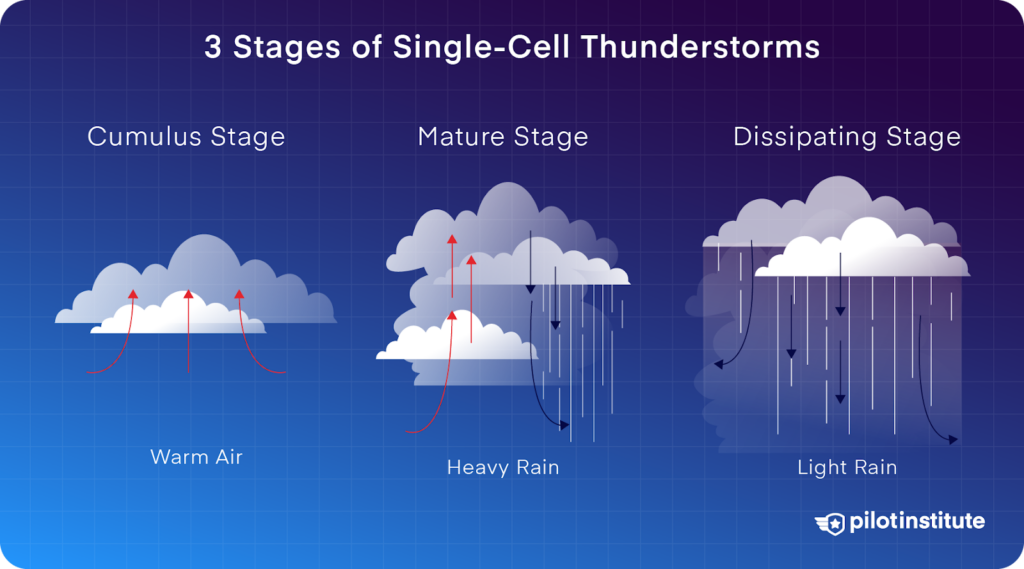
Severity Rating: Low
Single-cell thunderstorms are the least intense type of thunderstorms. They last for 30 to 60 minutes and undergo a certain life cycle:
- Cumulus stage: This occurs when warm air rises and creates a cumulus cloud.
- Mature stage: That’s when the storm is at its worst, followed by rain and lightning.
- Dissipating stage: As the storm begins to dissipate, downdrafts persist.
Even though single-cell thunderstorms have a low severity and last for only for a short period, they can cause heavy rain, lightning, and occasionally small hail. These thunderstorms typically take place during warm and humid summer days.
Multi-Cell Thunderstorms
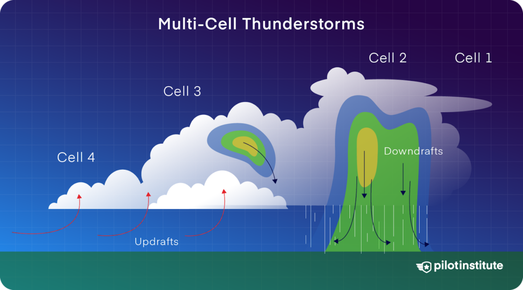
Severity Rating: Low to Moderate
Multi-cell thunderstorms develop and last longer than single-cell thunderstorms. They comprise a group of individual cells in different developmental stages, moving as a single unit.
Key weather features include:
- Multiple updrafts and downdrafts.
- A storm that can last several hours.
- Can turn into a deadly squall line thunderstorm.
Multi-cell storms can develop in groups known as clusters. The system as a whole can last for several hours while the individual cells dissipate in 20 to 60 minutes. These thunderstorms can produce strong winds, brief tornadoes, and heavy rain.
Squall Line Thunderstorms
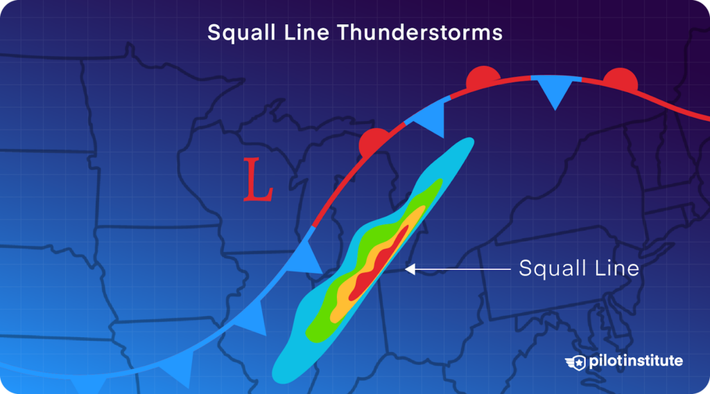
Severity Rating: High
Squall Line thunderstorms are a subclass of multi-cell thunderstorms. These severe thunderstorms take form in a narrow band, organized in a straight line that presents serious threats while you’re flying.
The main highlights include:
- A line formation that can extend for hundreds of miles.
- The storms can persist for several hours.
- They often develop before or after cold fronts.
Squall line thunderstorms have the potential for severe weather conditions, including strong straight-line winds, microbursts, wind shear, and flooding.
Supercell Thunderstorms
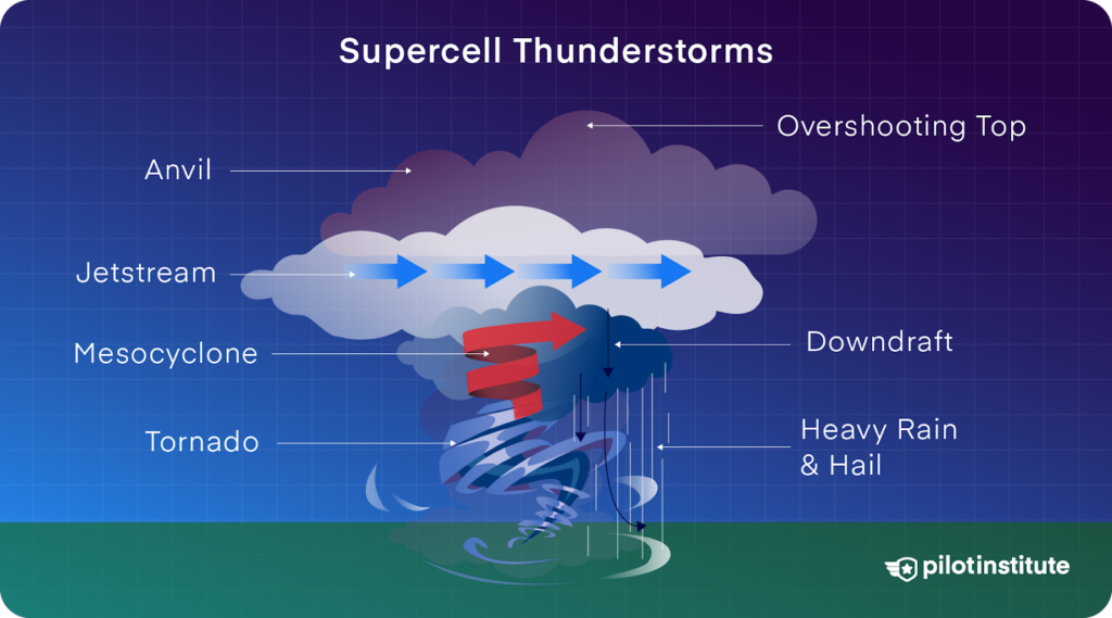
Severity Rating: Very High
Supercells are the strongest and most severe type of thunderstorms. Supercell thunderstorms get their reputation from what’s known as a mesocyclone, which is a strong, continuously rotating updraft.
Supercells tend to cause:
- Hailstones – above a golf ball size.
- Strong winds.
- Tornadoes.
- Constant rain and flash floods.
Supercells last for several hours and spread hundreds of miles across. They are dangerous while flying because of the heavy turbulence accompanied by sudden updrafts and downdrafts. These thunderstorms cause a majority of the tornadoes in the United States.
Impact of Thunderstorms on Aviation
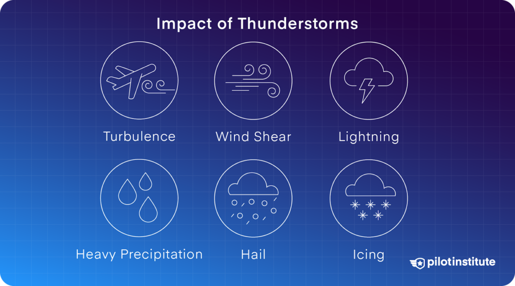
Thunderstorms are among the most dangerous of all the meteorological conditions that you can encounter during a flight. They present a variety of risks that can compromise flight safety:
Turbulence
Thunderstorms are the leading cause of turbulence. The conditions within a storm have air movements that are forceful enough to move an aircraft violently. This turbulence can:
- Cause loss of aircraft control.
- Can lead to structural damage of the aircraft.
- Make the passengers and crew members uneasy.
Wind Shear
Wind shear is a rapid variation in wind speed or direction, making it dangerous when you’re taking off or landing. Thunderstorms can produce microbursts, which cause intense downdrafts, pushing your aircraft toward the ground.
Lightning
While modern aircraft can withstand lightning strikes, lightning can still pose risks:
- While flying, you can lose vision for a while.
- Disturbance of navigation and communication instruments.
- Sometimes, the aircraft’s structural and/or systems may become affected.
Hail
Thunderstorms can produce hail, which is bad for the aircraft, windshield, and engines. Small hail stones can cause pitting and reduce your aircraft’s performance. It’s recommended to avoid hail as much as possible while you’re flying.
Icing
At higher levels of severe storms, supercooled water droplets can cause a rapid build-up of ice on your aircraft. This can lead to an increase in the aircraft’s weight and cause unwanted aerodynamic changes.
Heavy Precipitation
Heavy rain or snow can reduce your visibility to near zero, making it difficult to see other aircraft, terrain, and obstacles. Rainfall is particularly dangerous during takeoff and landing, as you may skid off the runway.
SIGMETs and Thunderstorms
Significant Meteorological Information (SIGMETs) exists to warn you of existing or developing adverse weather, including thunderstorms. Let’s learn more about them.
What Are SIGMETs?
SIGMETs provide you with in-flight weather advisories and critical information to improve flight safety. They are one of the most effective ways for you to prepare and learn about en route adverse weather conditions.
When Is a Thunderstorm SIGMET Released?
Weather services issue SIGMETs for thunderstorms when they meet the following criteria:
- Surface winds gusting 50 knots or higher.
- Hail of 3/4 inch diameter surface or larger.
- Tornadoes.
- Line, embedded, or area thunderstorms.
- Thunderstorms equivalent to and above VIP level 4 that cover 40% or more of a region of at least 3,000 square miles.
Why Are SIGMETs Important?
SIGMETs provide many benefits and advantages to you, including
- Real-time updates: You will receive up-to-date and current information about adverse weather conditions such as icing, thunderstorms, volcanic ash, etc.
- Area coverage: SIGMETs cover large areas (3,000 square miles) and contain information about weather conditions that can pose a threat during your planned route.
- Mandatory briefing: As a pilot, you must check the SIGMETs during the preflight weather briefing.
- In-flight updates: Since the weather changes rapidly, you can also receive SIGMETs in-flight.
To learn more, read our article on AIRMETs Vs. SIGMETS: What’s the Difference?
How to Stay Safe: Thunderstorm Forecasts
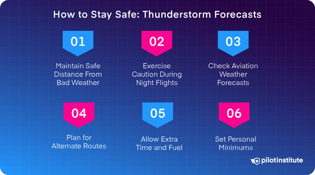
Never fly directly into a thunderstorm. The FAA recommends maintaining a distance of at least 20 Nautical Miles (NM) between a thunderstorm and your aircraft. If you have to deviate, choose the side of the thunderstorm with the best visibility.
Note: During night flights, you should use extreme caution as lightning can cover up a thunderstorm’s true size and location.
Here’s what you can do to avoid bad weather:
Use Aviation Weather Forecasts
Consider checking multiple weather outlets before your flight:
- Start early: It is advisable to check the weather forecast at least an hour before your intended departure.
- Use multiple sources: For a complete weather overview, you should use multiple sources, like the National Weather Service and Flight Service Station (FSS). The FSS provides 24/7 preflight weather information by calling 1-800-WX BRIEF.
- Understand the limitations: Don’t forget that weather predictions can easily change. If available, Automatic Dependent Surveillance-Broadcast (ADS-B) receivers on board can provide you with in-flight weather information.
Safe Flight Planning Tips
These are some tips you should consider when planning a flight:
- Plan alternate routes: To avoid getting stuck along the way because of thunderstorms, make sure you plan for different possible routes – Plan B and Plan C.
- Allow extra time and fuel: You should make allowances for unexpected diversions from thunderstorms or stops during the flight.
- Set personal minimums: Decide in advance which weather conditions you feel safe to fly in. When in doubt, ask ATC for help or divert.
National Weather Service Resources
The National Weather Service offers several valuable resources for aviation weather updates:
- Aviation Weather Center: Provides weather information and forecasts specifically for aviation.
- Convective SIGMETs: These include outlook maps of regions where severe and possible thunderstorms may occur.
- National Convective Weather Forecast: Illustrates the likelihood of thunderstorms and the area they will most likely cover.
Always Put Safety First
Remember, no flight is worth risking your safety. If you have doubts about thunderstorm activity, it’s always better to stay on the ground or plan a different route.
Now that you know about the different types of thunderstorms, you can use weather forecasts and other technology to make better decisions. Always avoid thunderstorms as best as you can because they hold a lot of destructive power.
Conclusion
Thunderstorms are truly fascinating but they can also be deceptive.
Some might seem harmless. But, they bring risks like wind shear, microbursts, and hail. They are anything but harmless.
You can’t take any of these storm types lightly. Single-cell storms may be short-lived. But, larger systems, like squall lines or supercells, can stretch far and cause real trouble.
Knowing how thunderstorms develop, and what to expect from each type, will help you stay safe, no matter where you are when the storm hits.
Fly safely!