
-
Key Takeaways
-
What Is a Weather Front?
-
Review of Cold and Warm Fronts
- Cold Fronts
- Warm Fronts
-
What Is an Occluded Front?
- “Occluded”
- Types of Occlusions
- Characteristics of Occluded Fronts
-
Weather Associated With Occluded Fronts
- Cloud Formation and Precipitation
- Turbulence and Wind Changes
- Icing Conditions
-
Impact on Aviation
- Flight Planning Considerations
- In-Flight Strategies
- Case Studies and Lessons Learned
-
Identifying Occluded Fronts on Weather Charts
- Symbols and Depictions
- Interpreting Weather Reports and Forecasts
-
Safety Measures and Best Practices
- Pre-Flight Preparation
- In-Flight Decision Making
- Equipment and Training
-
Frequently Asked Questions
- What Are Occluded Fronts Best Described as?
- What Is the Occlusion Stage?
- Are Occluded Fronts Fast or Slow?
- What Happens During a Stationary Front?
-
Conclusion
As a pilot, will you be able to recognize an occluded front when one comes your way? Will you know how to respond to the challenges it comes with?
Many student pilots feel lost when studying occluded fronts, and it’s easy to see why. But while they’re often overlooked and misunderstood, the fact is that they will come your way.
Together, let’s untangle the mystery of occluded fronts with a clear and steady approach. Understanding what you’re flying into will only prepare you for smooth flights ahead.
Key Takeaways
- Occluded fronts merge warm and cold front hazards, causing complex, severe weather.
- Identifying occluded fronts on charts is important for flight planning and safety.
- Pilots should anticipate heavy rain, storms, icing, and turbulence with occluded fronts.
- Learning about occluded fronts improves both decision-making and risk management.
What Is a Weather Front?
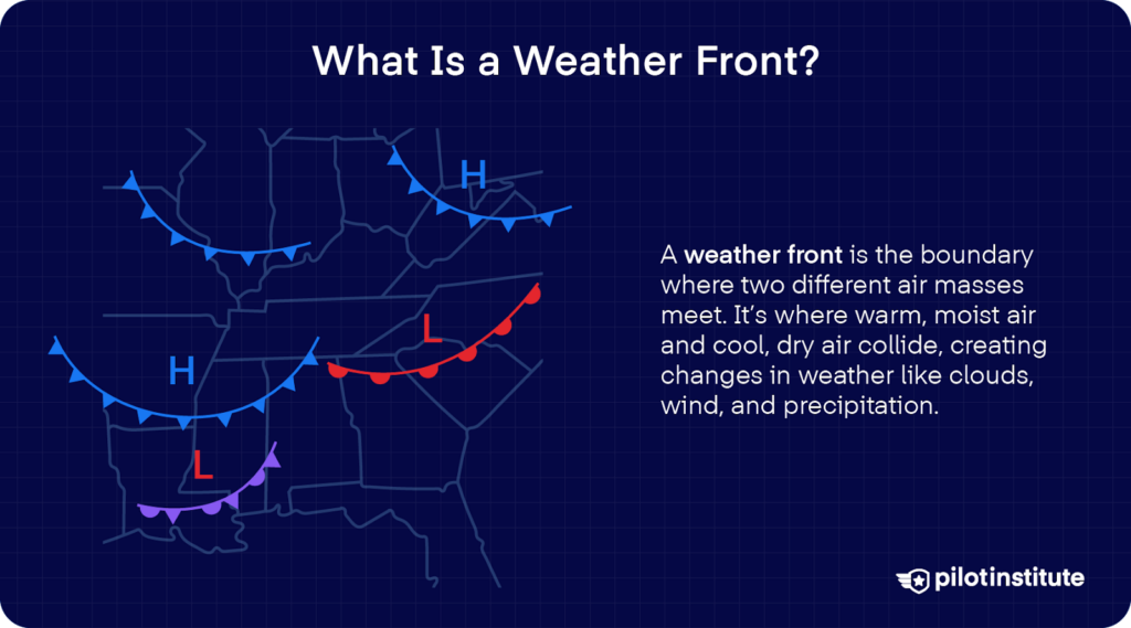
It’s best to begin with the basics, starting with the name. So, what is a front?
When air stays in the same region for days or longer, it takes on the features of its surroundings. The air’s characteristics, like temperature and moisture, become relatively uniform over a large area, and an air mass is formed.
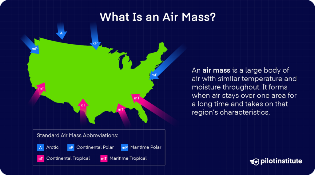
As an air mass moves over land and water, it eventually meets another air mass with different characteristics.
When warm and cold air masses meet, they do not mix because they have different densities. The boundary where these air masses meet is what we call a front. And when you hear about one approaching, expect a change in the weather soon.
There are four types of fronts. They are:
- Cold Front
- Warm Front
- Stationary Front
- Occluded Front
Review of Cold and Warm Fronts
But before we dive into occluded fronts, we must first understand cold and warm fronts.
Cold Fronts
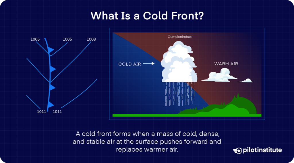
A cold front forms when a mass of cold, dense, and stable air pushes forward and replaces warmer air. Cold fronts move fast, usually at 25 to 30 miles per hour. Although in some extreme cases, they can reach 60 mph.
You could picture a cold front like a snowplow. Because the cold air is so dense, it stays low even when it meets a warm air mass. As these air masses collide, the cold air wedges underneath the warmer, lighter air and pushes it upward.
Cold Front Weather
How can you tell if a cold front is coming? The temperature suddenly drops as the warm air rises from the ground. Depending on the warm air’s stability, this process can form different kinds of clouds.
As the front moves over you, towering cumulus or cumulonimbus clouds remain. You should be prepared for heavy rain, lightning, thunder, or even hail. Severe cold fronts can even produce tornadoes.
Visibility worsens and winds become gusty during the passage. Temperatures and dew points also drop fast. The barometric pressure falls sharply, then slowly rises after the front moves on as it passes.
Warm Fronts
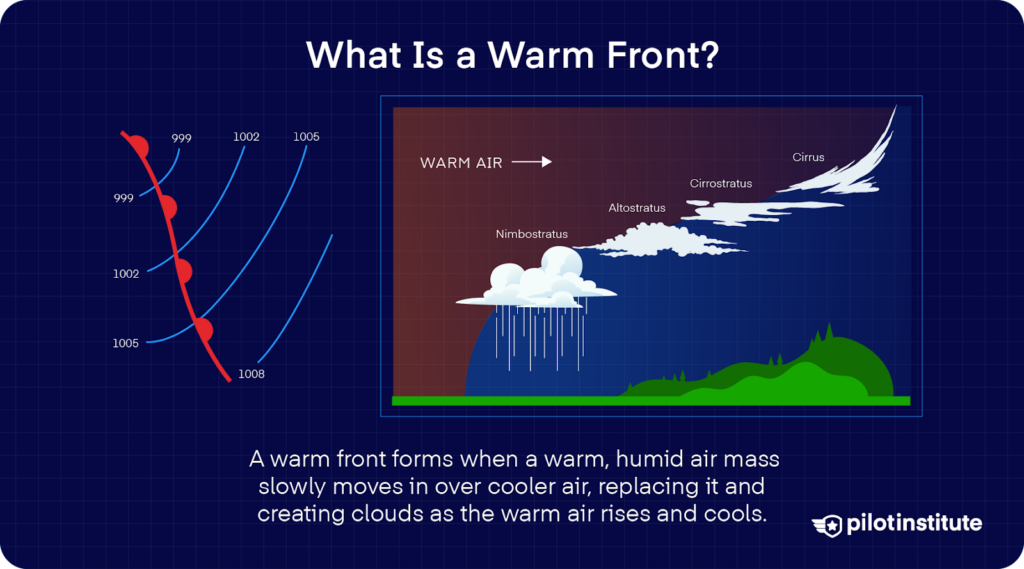
Now on the flipside, when a warm air mass moves in and replaces cooler air, you get a warm front.
The warm air gently slides over the cooler air, gradually pushing it out. This warm air is often humid, and as it rises, it cools. This cooling causes condensation, which makes clouds form.
Warm fronts move more slowly than cold fronts, usually only at 10 to 25 mph.
Warm Front Weather
It’s common to experience light to moderate precipitation, like rain, sleet, snow, or drizzle. Winds usually come from the south-southeast, and the air feels cool or cold, with a rising dew point.
Watch out, because this creates the perfect conditions for icing.
As the warm front passes, the sky becomes dominated by stratiform clouds, and maybe even some drizzle. Visibility remains low, then starts to improve.
Then, after the front moves through, you might see stratocumulus clouds and light rain showers. Visibility improves, although hazy conditions may linger for a short while.
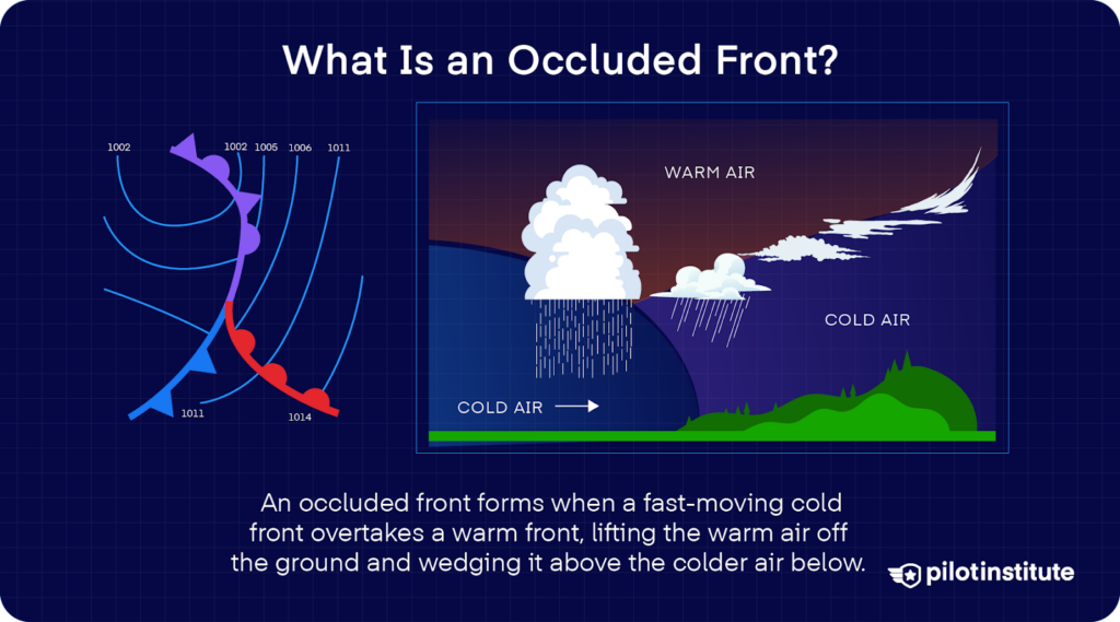
What Is an Occluded Front?
“Occluded”
The term “occluded” might not be familiar to some. It simply means to be stopped, to be cut off, or to be obstructed.
To understand how this fits into our subject matter, let’s review three basic ideas:
- Cold fronts move faster than warm fronts.
- Cold air sinks; warm air rises.
- In a warm front, the air ahead of the warm air mass is colder.
Sometimes, a fast-moving cold front will catch up to a slow-moving warm front. As the cold air mass overtakes the warm air mass, it wedges warm air upward, and the cold air mass crawls underneath.
It eventually reaches the front and meets the cold air mass on the other side. The cold air masses push and meet in the middle.
When this happens, the warm air mass gets entirely occluded, or cut off, from the ground and pushed aloft. What you get, in essence, is an occluded front.
Types of Occlusions
Remember the two cold air masses underneath? Well, they don’t always have the same temperature.
Depending on which is colder, you can get two types of occluded fronts: a cold occlusion and a warm occlusion.
Cold Occlusion
A cold front occlusion occurs when the air mass behind the fast-moving cold front is colder than the cool air mass ahead of the warm front.
What happens here? The cold air replaces the less cool air, and it forces the warm front upward into the atmosphere.
The weather around a cold front occlusion is usually a mix of weather found in both warm and cold fronts, but only if the air is relatively stable. This is common in regions where cold air moves into an area of cool air.
Warm Occlusion
On the other hand, a warm front occlusion happens when the cool air behind the advancing cold front is warmer than the cold air ahead of the warm front. In this case, the overtaking cool air can’t dive beneath the colder air, so it rides over.
If the air forced upward is unstable, prepare for weather that’s more severe than that in cold front occlusion. Expect embedded thunderstorms, rain, and fog.
Warm occlusions often happen in coastal areas where cool maritime air overtakes colder continental air.
Characteristics of Occluded Fronts
An occluded front combines features of both warm and cold fronts. It brings cold, cool, and warm air masses together, which makes for a jumble of weather features from each type.
As you can expect, the weather near occluded fronts is complex and unpredictable. Multiple air masses are colliding with each other, so expect conditions to change quickly.
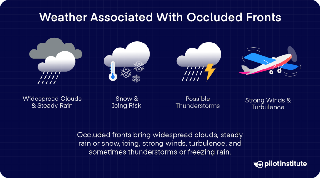
Weather Associated With Occluded Fronts
Occluded fronts are catalysts for changes in the weather. These fronts all stem from temperature and pressure differences—the main ingredients in every atmospheric process.
Cloud Formation and Precipitation
As the warm air is forced upward, it begins to cool and condense. This results in widespread cloudiness and precipitation. You’ll often see layers of stratiform clouds, sometimes even cumuliform if the air is unstable.
Visibility can drop sharply because of this mix of cloud types, and it might call for IFR conditions.
What’s the weather like along an occluded front? You might experience steady rain and drizzle, thunderstorms, freezing rain, and even small hail. Cold-air funnels or cold-core tornadoes can even form along the front in rare cases.
Turbulence and Wind Changes
Occluded fronts often bring strong winds and sudden wind shifts. As air masses collide, turbulence increases, especially in storms embedded along the front. Stay on the lookout; turbulence may appear before, during, and after the front moves through.
But there’s another danger that might be lurking around an occluded front. When cold air catches up with warm air, it creates a sharp temperature difference.
Surface winds associated with a frontal passage can also be quite different from winds aloft. For example, as a cold front passes, surface winds may shift from southwesterly to northwesterly, while winds above may continue from the west.
All these and more create the perfect recipe for wind shear.
Icing Conditions
Occluded fronts are notorious for something else. When you have extensive cloud layers and precipitation, you get the ideal conditions for structural icing.
Worse yet, there could be supercooled large droplets (SLD) present near these fronts. These SLDs can lead to freezing rain or freezing drizzle.
How can you stay on the safe side? If you’re flying in clouds at or below 0 °C (32 °F), you should be prepared for icing and exercise caution.
And since icing can occur at any altitude, you might have a harder time selecting a flight level.
Impact on Aviation
Flight Planning Considerations
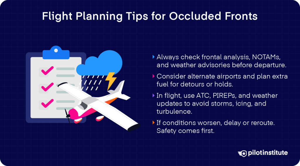
With all these dangers standing in your way, your best layer of safety is being ready for them. Before take-off, always include frontal analysis in your weather briefing, and look out especially for occluded fronts.
Don’t forget to review NOTAMs and weather advisories. They’re helpful tools in spotting occluded fronts and related weather phenomena.
Occluded front in forecast, do you know the dangers ahead? How do you plan to proceed?
All pilots—including you—are responsible for gathering complete weather data before departure.
It’s wise to reroute around bad weather or reschedule the flight. But if you plan to make a detour or hold for weather, don’t forget to account for fuel.
Another important thing, make sure you consider alternate airports with better conditions if the front moves through your area.
In-Flight Strategies
Once you’re airborne, stay flexible. You may need to fly around or above the occluded front, but you’ll also have to consider your aircraft’s limits.
Keep a close eye on in-flight weather updates from ATC, En Route Flight Advisory Service (EFAS), ATIS, ASOS/AWOS, and onboard systems.
To get real-time reports from other pilots, make use of Pilot Reports (PIREPs) and urgent PIREPs.
You can always contact ATC or Flight Service for guidance; don’t be afraid to speak up. They’ll help you avoid embedded thunderstorms, and you can even request altitude changes to escape icing or turbulence.
If conditions get too rough near descent, don’t hesitate to delay or hold off until it’s safe to continue.
Case Studies and Lessons Learned
Safety lies in your choices, and previous cases have shown us why.
In December 2022, Hawaiian Airlines Flight 35 was flying at FL400, above a cloud layer between FL370 and FL380.
The flight crew chose a higher flight level to avoid the cloud, until another update from ATC reported that the cloud tops had grown to FL410.
The flight was on track to enter the cloud. Seconds later, the airplane was rattled by severe turbulence of more than 2 Gs.
The thing is, the flight crew had been briefed about an occluded frontal system in the area. The occlusion was part of a Kona storm, which brought embedded thunderstorms and strong updrafts.
Their mistake? The flight crew chose to fly over the cloud, when they should have flown around it.
The operator’s flight manual recommends avoiding thunderstorms by 20 nautical miles laterally, or overflying by at least 5,000 feet if tops were above 25,000 ft.
This accident led to 24 injuries and serious damage to the cabin.
Identifying Occluded Fronts on Weather Charts
Symbols and Depictions
Charts give us a good clue on features like cloud cover, precipitation, and wind changes so that you can plan your flight path accordingly.
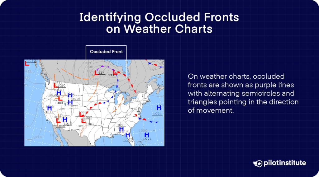
Do you know how to spot an occluded front on a map? Surface analysis charts show us the big picture when locating fronts. These charts also tell you which direction the fronts are moving, and they’re updated every three hours.
Warm fronts are shown as a red line with semicircles. Cold fronts lie along the blue lines with triangles on the chart.
For an occluded front, these symbols are combined. They’re shown as a purple line with alternating semicircles and triangles pointing towards the front’s movement.
Interpreting Weather Reports and Forecasts
Hawaiian Airlines Flight 35 had a weather radar onboard the flight, which does come in handy in detecting storm cells. But according to the flight crew operating manual, the radar tends to miss weather that “has small droplets,” like clouds.
So, how can you get the full picture of the weather?
Most weather reports mention the presence of occluded fronts. For example, Area Forecasts (FAs) give you frontal positions and expected movement.
In METARs and TAFs, you might see terms like “FROPA,” which stands for frontal passage. They might even mention frontal effects like precipitation or wind shifts.
Stay tuned for PIREPs to get real-time updates near occluded fronts. They give insights that forecasts or radars might not be able to relay.
You should also use weather apps and onboard weather systems. They often overlay frontal symbols and forecast data, so you can track occlusions as you fly.
Safety Measures and Best Practices
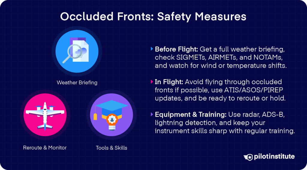
Pre-Flight Preparation
The best way to dodge the hazards of an occlusion is to identify them from the start. From the ground, conduct a comprehensive weather briefing, and pay close attention to frontal activity.
Take note of the front’s location and type. Keep its speed and direction in mind as you make your briefing.
We also mentioned how fronts usually give you signs before they arrive. Do you remember what to look out for? Check to see if there’s any sudden wind shifts or temperature changes.
Be sure to check SIGMETs and AIRMETs for icing, turbulence, and convective activity. And don’t forget to review NOTAMs in case there are airspace restrictions or airport closures due to weather.
In-Flight Decision Making
Let’s say you get caught heading into an occluded front in the air. How can you escape danger?
First, make sure you have full situational awareness. It will help to check for ATIS, ASOS, or AWOS updates while airborne.
Wherever possible, avoid flying directly through occluded fronts, especially if your aircraft isn’t equipped for icing or turbulence. You should stay flexible, so be ready to reroute and climb above or stay away from the front.
Submit a PIREP to give others a heads-up if you encounter severe weather. Real-world pilot reports are often the most reliable source for weather conditions as they happen.
If you find yourself in instrument conditions, stick to IFR procedures. Make the most of the tools in your cockpit and coordinate effectively with your crew.
Remember that holding or delaying descent is always a wise option if conditions get worse during your approach.
Equipment and Training
When dealing with adverse conditions, it helps to have the right equipment.
Make sure your aircraft has the appropriate weather detection tools. Your onboard radar lets you see precipitation and storm structures ahead in real time, which is especially useful near occluded fronts where mixed cloud and rain systems happen.
Both ADS‑B In and XM Weather give you real-time weather updates. They deliver radar imagery, and even METARs, TAFs, AIRMETs, SIGMETs, and NOTAMs.
Lightning activity often points to strong updrafts and turbulence, which are common near occlusions. Stormscopes and lightning detection systems show electrical discharge in nearby clouds.
But with all that said, having the right gear means nothing without the right knowledge. So make sure you’re always training for the worst.
Review weather theory and instrument flying skills regularly. If you have access to simulators or training devices, practice flying in scenarios involving occluded fronts.
There are organizations that offer advanced meteorology courses or weather seminars. Consider attending them to strengthen your understanding.
Frequently Asked Questions
What Are Occluded Fronts Best Described as?
Occluded fronts are mixed boundaries that form when a cold front overtakes a warm front and meets another cold air mass on the other side.
They’re called occluded because the warm air gets lifted completely off the ground. This creates a surface boundary between cold and cool air masses, with a layer of warm air aloft.
What Is the Occlusion Stage?
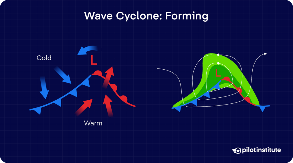
When we’re dealing with wave cyclones, the occlusion stage happens at the mature phase of the system. During this stage, the wave cyclone starts to weaken.
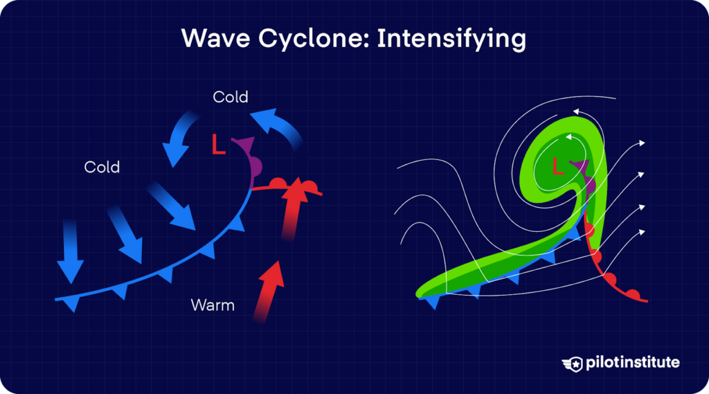
A wave cyclone starts with a stationary front separating warm and cold air. Sometimes, a disturbance forms along this boundary, and it creates a low-pressure wave. Precipitation is heaviest in the zone where warm air is getting lifted along the front.
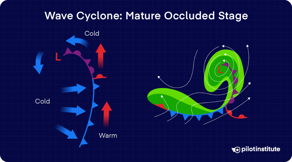
As the wave intensifies, both the cold and warm fronts become better organized. Then, eventually, as the cold front overtakes the warm front, an occluded front forms. The wave becomes a mature low.
This occlusion gradually cuts off the warm air supply that fuels the system. With warm air running out to keep the process going, the cyclone weakens and eventually dies out.
Are Occluded Fronts Fast or Slow?
We learned that cold fronts are fast (25 to 30 mph), and warm fronts are slow (10 to 25 mph). Naturally, we’re inclined to wonder, how about occluded fronts?
Since occluded fronts are formed from the fusion of two fronts moving at different speeds, it will all depend on the speeds of these fronts, along with several other variables in the atmosphere.
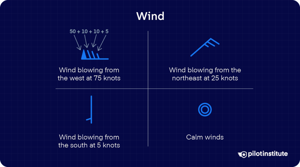
What you can know for sure are the wind speeds along a particular front. Surface analysis charts use symbols to tell you the wind speed and direction in different locations.
Station METAR/TAF reports also include hourly wind speed and direction. You can check out AIRMETs and SIGMETs, in case they describe weather conditions around an occluded front.
QuikSCAT and scatterometer data give surface vector wind fields, and they can show the strength and direction of winds along and around fronts.
What Happens During a Stationary Front?
When two air masses push against each other with about the same strength, the boundary between them remains stationary. This boundary is appropriately called a stationary front.
It can stay in the same area for several days and affect the weather. The weather along a stationary front is usually a mix of what you’d see in both warm and cold fronts. You’ll likely see clouds, light rain, or even storms.
Conclusion
Occluded fronts bring complex weather challenges that demand careful planning and execution. But we’ve also seen that they’re easier to understand than many pilots think.
Occluded fronts will come your way, and when they do, will you be ready? Make sure your understanding is always sharp, and integrate what you learn into your flight prep.
When you know the hazards ahead, you’ll be ready to navigate the challenges of occluded fronts with ease and skill.