-
Top 5 best drones for mapping and surveying
- 1. DJI Mavic 3 Enterprise
- 2. DJI Matrice 300 With a Zenmuse P1
- 3. DJI Phantom 4 RTK
- 4. Yuneec H520 RTK
- 5. senseFly eBee X
-
What to look for in a mapping and surveying drone
- 1. Mechanical Shutter
- 2. Fixed-wing vs Multirotor
- 3. Autonomous flight capability
- 4. Long battery time
- 5. 4K camera
- 6. RTK compatibility
- 7. Interchangeable payload
-
Final thoughts
Of the many commercial uses of drones, mapping and surveying seem like some with the most natural fit. By using a drone, surveyors no longer need to spend several days or weeks walking through the survey area and taking manual measurements. Not only do drones make surveying jobs easier, but they can also produce data and models that are more accurate.
However, doing a drone survey is going to take more than just buying any standard commercial drone. Not all drones are made for the job, so here’s a short list of the best drones for mapping and surveying.
Top 5 best drones for mapping and surveying
1. DJI Mavic 3 Enterprise
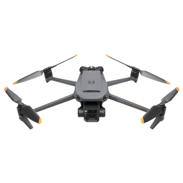
The Mavic 3 Entreprise is a long-awaited replacement to the DJI Phantom 4, which has long served as the workhorse of drone mappers worldwide. The reason that this drone is awesome for mapping is because it’s one of a handful of drones that has a mechanical shutter. A mechanical shutter will dramatically improve your drone models because you won’t have rolling shutter issues which create blur in your images when you are flying.
The micro 4/3 sensor on the Mavic 3 Enterprise is significantly larger than the 1 inch sensor on the Phantom 4. This means that the drone has better low light capabilities, which will help you get better photos outside of peak sun hours or during cloudy conditions. Additionally, the Mavic 3 Enterprise has a flight time of up to 45 minutes, which is more than a 50% increase compared to the Phantom 4.
Learn how to create professional drone maps.
2. DJI Matrice 300 With a Zenmuse P1
If you want the best setup, the DJI Matrice 300 with a Zenmuse P1 can’t be beat.
The Zenmuse P1 is a full frame camera that’s on a 3-axis gimbal. It has a global mechanical shutter and it can produce models with up to 3 cm level accuracy without ground control points. The only real downsides are the size of the drone and the extremely high cost.
3. DJI Phantom 4 RTK
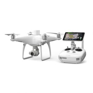
For a very long time, the Phantom 4 drone from DJI was considered the standard of professional-grade drones. When the RTK version of the Phantom 4 was released several years ago, it instantly changed the game as far as mapping professionals were concerned. It’s a drone that came with the industry-defining features of the Phantom 4 and was further augmented with RTK technology.
The Phantom 4 RTK retains all the best qualities of the standard Phantom 4 – a 1-inch CMOS sensor, a 3-axis gimbal, and a 5870 mAh battery that can keep the drone airborne for up to 30 minutes. Located at the top of the drone is the characteristic RTK module. Combined with the D-RTK2 ground station, this drone can collect spatial data at centimeter-level accuracy.
The Phantom 4 RTK also comes with an upgraded controller with a hot-swappable battery, a slot for a microSD card to store survey data, and an option for 4G connectivity for cloud-based backup. The special GS RTK app was developed specifically for this drone, allowing for intuitive flight planning and easy execution on the field.
The biggest limitation of the Phantom 4 RTK is the fact that it was not designed to be compatible with a Post-Processing Kinematic (PPK) workflow. It also does not have an interchangeable payload which restricts you to mapping via photogrammetry.
4. Yuneec H520 RTK
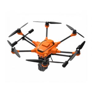
The H520 RTK is Yuneec’s entry into the market for mapping drones. Sporting the signature hexacopter build of Yuneec, the H520 RTK offers a wide range of solutions for mapping professionals. As the name implies, the drone comes with a built-in RTK module and a Network RTK base station.
There are a couple of things about the H520 RTK that make it stand out. First off is the fact that it does not have a fixed payload. Yuneec offers a range of high-end accessories for the H520 RTK including the CGOET thermal camera and the E90 20MP high-speed camera. These are sold separately but can certainly expand the possibilities of the drone.
The H520 RTK was also designed to be compatible with a PPK process. PPK is useful when doing mapping surveys in areas where communication between the drone and the ground station is not assured. Instead of doing real-time corrections to spatial data, PPK allows for coordinated data collection so that they can be corrected during post-processing.
5. senseFly eBee X
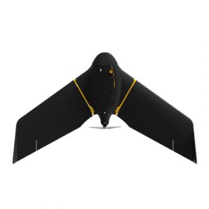
Few companies have as much experience in aerial mapping as senseFly, so it only makes sense for one of their drones to be included in this list. Our choice is the eBee X, a fixed-wing drone that offers enough flexibility for any mapping needs.
The eBee X is an extremely versatile drone. It can accommodate both PPK and RTK workflows and is compatible with a wide range of payload options both from senseFly and third-party companies. These include the SODA 3D mapping camera and the Parrot Sequoia multispectral sensor, among others.
As we have mentioned, the best thing about flying a fixed-wing drone is the fact that it can stay airborne for a really long time on a single battery cycle. In the case of the eBee X, it can fly for up to 90 minutes uninterrupted – a huge value if you’re surveying a wide area. When it comes to planning your surveys, the eBee X is compatible with the widely used Pix4D suite of mapping platforms.
The last thing you need to know about the eBee X is that it’s very expensive – the drone with the accessories can cost up to $15,000. It’s a huge sum, but we’re sure that lots of drone mapping professionals won’t mind the price for such a dependable and high-quality drone.
What to look for in a mapping and surveying drone
To help us narrow down the wide selection of commercial drones, let’s look at the qualities we should look for in a mapping survey drone. These qualities prioritize both the quality of data that the drones can collect as well as the ease with which they can be used for large-scale aerial surveys.
1. Mechanical Shutter
If you are doing drone mapping professionally you should prioritize a drone that has a mechanical shutter. It is possible to create drone models from basically any drone, but if it doesn’t have a mechanical shutter the quality will suffer and it will take a much longer time to map the area.
With a regular shutter, the camera lens is exposed to light one line at a time. This produces blur if the drone is in motion while it takes the photo. In contrast, mechanical shutters take a photo by exposing the whole shutter simultaneously.
2. Fixed-wing vs Multirotor
Although multirotor drones are more common nowadays, mapping surveys can also benefit from the unique capabilities of fixed-wing drones. Choosing one over the other will depend on your budget, the size of your survey area, and your level of expertise as a drone pilot.
Multirotor drones are much easier to fly and maneuver, mostly because they can hover in place. Since they are so common nowadays, they are also much cheaper compared to professional-grade fixed-wing drones. However, they suffer in terms of battery efficiency as they rely on rotors to generate both lift and propulsion. If you’re surveying an area that only measures a few acres wide, then a multirotor drone may be the practical choice.
Fixed-wing drones truly shine if you are surveying a few hundred hectares of land. The design of fixed-wing drones allows them to generate lift by the mere act of gliding through the air. Since their rotors are only responsible for providing propulsion, they can stay airborne far longer on a single battery cycle. However, they also need a more skilled pilot at the helm.
3. Autonomous flight capability
More often than not, aerial mapping surveys will require that you fly over an area multiple times to ensure data consistency and accuracy. To do this, you must ensure that the drone flies along the same flight path every single time. Doing this manually is virtually impossible, so you’re going to need to use a drone that can be programmed for autonomous flight.
Autonomous flight isn’t a feature that you can just activate with any drone. You will probably need to use another software (such as Litchi) to create these flight paths, which will then be transmitted to the drone’s remote controller. By removing heavy pilot input, errors due to human lapses can be avoided.
4. Long battery time
It’s not unusual for mapping surveys to cover areas that are several hectares large. Even with the speed with which drones can fly, a standard drone can’t finish an entire survey on a single battery cycle. Thus, there will certainly be a need for the drone to fly back to a designated landing spot so that its batteries can be swapped.
As you can imagine, landing and deploying the drone multiple times in a single survey will take lots of precious minutes. To optimize the time that you spend in the field, you will want a drone that can fly for at least 30 minutes uninterrupted. This is pretty much a standard number for most modern drones.
5. 4K camera
Photogrammetry is the most common technique used for aerial surveying. The technique uses a series of overlapping geotagged photos taken by the drone to infer the dimensions of all the features on the ground. Although photogrammetry has limitations, it’s a widely favored option because of how accessible and inexpensive it is.
The key to data quality in photogrammetry is the resolution of the camera. You will want to use a camera that can capture as much of the fine details on the ground as possible, allowing the software to recreate these features during 3D modeling. Cameras that can capture 4K videos and 12 MP photos are standard nowadays, but you can go for as high a resolution as available.
6. RTK compatibility
All drones that are commercially available today come with a built-in GPS receiver to allow for locational tracking. This GPS feature provides flight stabilization as well as the tracking that the drone needs for autonomous flight. When doing mapping surveys, the GPS receiver also automatically geotags photos. By embedding the photos with spatial data, the mapping software can recreate an entire 3D model by “stitching” the photos together.
Depending on several conditions, GPS data can have errors of up to a few meters. While this may not be significant to some applications, fields like urban planning and construction may benefit from more accurate measures.
In recent years, drone manufacturers have addressed this problem by integrating RTK technology into mapping drones. RTK stands Real-Time Kinematic, a method by which GPS data can be improved by differential measurements. RTK relies on a constant correction of GPS data relative to a fixed ground station. Through this technique, locational accuracy can be improved to centimeter-level.
RTK drones provide a huge jump in terms of data accuracy for mapping and surveying. However, the upgrade from standard GPS to RTK will also be very expensive.
7. Interchangeable payload
While photogrammetry is the more common mapping method used, it’s far from being the best. If you need more detail in your model, then an alternative would be to use a Light Detection and Ranging (LiDAR) sensor. This sensor emits pulses of light that bounce off solid objects in the survey area. By calculating for the time it takes for these pulses to return to the sensor, LiDAR more accurately determines the size and shape of individual features.
Drone mapping technology can even be combined with other imaging technologies such as thermal imaging and multispectral imaging to generate a variety of data maps. This has proven useful in several industries, from the management of crop farms to surveying of utility pipes.
Drones that come with built-in LiDAR sensors or thermal cameras are rare. If you want these functions, you will have to go with third-party accessories and a drone that can accommodate different types of payload. Such drones are certainly at the high-end and much more expensive than many commercial drones.
Although mapping is a highly technical application of drones, it doesn’t exactly take a highly sophisticated drone to do the job. At the minimum, you’ll need a drone with a good camera, autonomous flight capabilities, and a GPS receiver. Scaling up operations with more advanced gear will require a huge investment but will also allow you to charge premium rates.
Final thoughts
Aerial mapping and surveying are some of the most lucrative fields in the era of commercial drone flight. It’s also one of the most technically demanding, creating a huge barrier to entry in terms of skill and technology. While this article doesn’t touch on the skill you need to be a professional drone mapper, we hope that we have pointed you in the right direction in terms of the hardware you’ll need.
Note: Pilot Institute is part of the Amazon Associates program. We may earn a commission on sales, although this does not increase the cost for you.