-
Key Takeaways
-
What Is a SPECI?
-
Why and When Is a SPECI Issued?
-
Key Components of a SPECI Report
- Type of Report, Station Identifier, Date & Time, and Report Modifier
- Wind Information
- Visibility and RVR
- Present Weather
- Sky Condition
- Temperature and Dewpoint
- Altimeter Setting
- Remarks
-
SPECI Validity and Duration
-
How to Read a SPECI METAR
-
Conclusion
In aviation, staying ahead of the weather is a must. When weather conditions shift unexpectedly, that’s when a SPECI report comes in.
A SPECI (or Special Report) offers a quick weather update between the routine METARs.
So, if there’s a sharp dip in visibility, a thunderstorm fires up, or the wind takes a sudden turn, a SPECI alert goes out. This is extremely helpful.
And these aren’t just minor updates, SPECIs are issued only when there’s enough change to potentially affect flight conditions.
Let’s explore how SPECIs are going to help you plan around unexpected weather twists.
Key Takeaways
- A SPECI gives updated weather information when significant conditions suddenly arise.
- They are triggered by events like changes in visibility, wind, or storms.
- Special reports include data on wind, visibility, cloud cover, temperature, and weather events.
- Understanding a SPECI helps you make safer flight decisions.
What Is a SPECI?

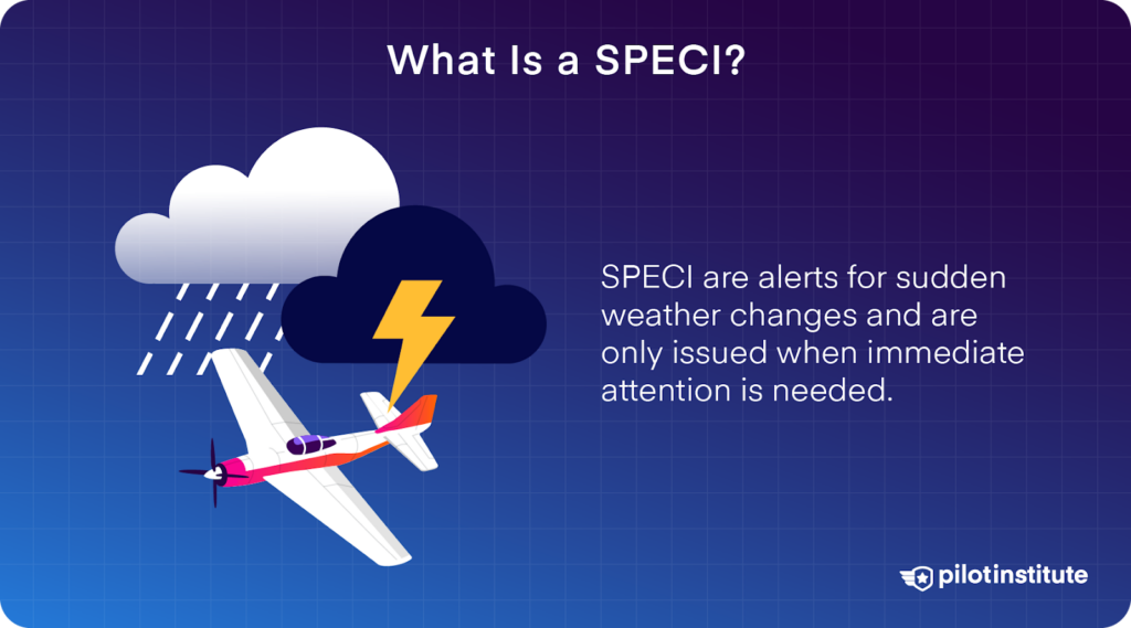
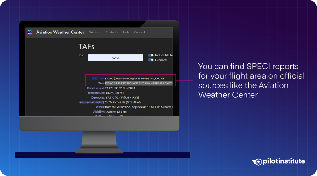
When there are significant changes in weather conditions, weather stations may issue a SPECI (Special Weather Report). Unlike METARs (Aviation Routine Weather Reports), which are issued at specific intervals, a SPECI is released when there’s an unexpected shift in weather you need to know right away.
For example, if a storm rolls in or visibility suddenly drops, a SPECI will be issued to inform you about them.
A SPECI covers elements like wind speed and direction, visibility, cloud cover, temperature, and pressure. If any of these elements drastically change between regular METAR reports, a SPECI will let you know about it as soon as possible. This allows you to make quick adjustments to your flight plan.
Basically, you can think of SPECIs as emergency alerts.
They’re issued only when something unusual or significant requires immediate attention.
Both METARs and SPECIs follow a standard format. So, wherever you are on the globe, you’ll know exactly what they say.
Why and When Is a SPECI Issued?

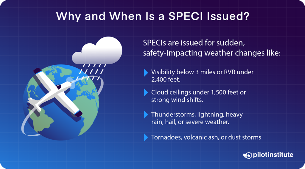
Certain weather events that could impact your flight’s safety will call for a SPECI.
When it comes to cloud cover and visibility, the rules for issuing a SPECI are based on something called the Highest Alternate Minima (HAM).
The alternate minima spells out the specific weather conditions that affect aircraft operations. If these conditions are met or exceeded, you’ll need to adjust your flight, such as using alternate landing procedures.
So, which weather events prompt a SPECI issue?
The FAA has published a list of criteria for a SPECI issue. Let’s look at each weather condition.
- A SPECI is issued if visibility drops below 3 miles or improves above a quarter mile after being lower.
- Runway visual range (RVR) under 2,400 feet triggers a SPECI, and another is issued if it rises to 2,400 feet or more within 10 minutes.
- Cloud ceilings below 1,500 feet or cumulonimbus clouds can trigger a SPECI.
- A sudden wind shift, a 10-knot or greater speed increase, a 45-degree or more direction change, or gusts exceeding limits may also cause a SPECI.
- Thunderstorms, lightning, or severe weather near the airport or flight path lead to a SPECI.
- Changes in precipitation type or intensity, like heavy rain or hail, can also result in a SPECI.
What do these mean for your flight? Well, these events can quickly affect visibility or runway conditions so much that they call for a special report.
Sharp fluctuations in temperature or pressure can affect aircraft performance, especially during take-off and landing. If either changes significantly within a short period, a SPECI may be issued.
Tornadoes, funnel clouds, volcanic ash, or dust storms are extremely dangerous to all pilots. This is why they also call for a SPECI issue.
Key Components of a SPECI Report

To ensure that you make safe and accurate decisions, it’s essential to know how to understand the data in these reports.
Do you know what you’ll find in a SPECI?
Just like a METAR, a SPECI covers the following elements:
- Type of report.
- Station identifier.
- Date & time issued.
- Report modifier.
- Wind information.
- Visibility.
- Runway visual range (RVR).
- Present weather.
- Sky condition.
- Temperature and dew point.
- Important additional remarks.
Now, let’s look at each part of the report.
Type of Report, Station Identifier, Date & Time, and Report Modifier
First up, you’ll see which type of report you’re looking at. This could be either METAR or SPECI.
After that, you’ll see the station identifier. This will tell you the airport or weather station where the report is issued. You will also find the date and time the report was issued.
The report modifier indicates whether the report was generated by an automated system or includes human observations.
Always make sure you’re looking at the most recent weather report for the correct airport.
Wind Information
The next thing you will find is wind information. This includes the wind direction in degrees and the wind speed in knots.
Will you be able to take off safely, or should you delay your flight? Strong winds or direction shifts of 30 degrees or more can severely impact your aircraft’s performance.
Always watch out for the letter “G” in the report. It stands for gusting winds and can be a sign of a tricky landing or take-off, especially for light aircraft.
Visibility and RVR
You’ll also find visibility information in the SPECI, measured in meters or statute miles. If you’re flying in VFR, it’s vital for you to know the visibility.
For example, visibility dropping below 5,000 meters can spell poor conditions for VFR operations. Thunderstorms (TS) or severe precipitation can also affect visibility and flight safety.
After that, you’ll see the runway visual range, which shows the visibility down a specific runway. Low RVR values, say, below 2,400 feet, can call for delaying takeoffs or landings, especially when the ILS is unavailable.
Present Weather
You’ll also see codes that indicate weather events, such as:
- RA – Represents rain.
- SN – For snow.
- TS – For thunderstorms.
The present weather section shows specific weather events that could impact operations. And if you see “TSRA,” that’s a red flag.
It stands for thunderstorms with rain, which is a tricky thing to fly through. Expect poor visibility, increased turbulence, and slippery runway surfaces.
Thunderstorms can also bring wind shear and lightning. If severe weather is reported, do you have a plan B? You should always stay ahead of the weather, so plan for potential delays or alternate routes.
Sky Condition
The sky condition is presented in oktas, which is eighths of the sky covered by clouds. This information is vital for determining cloud ceilings, especially during landing approaches.
Cloud cover is reported as:
- FEW (Few clouds)
- SCT (Scattered)
- BKN (Broken)
- OVC (Overcast)
These are followed by the altitude of the cloud base in hundreds of feet.
Low cloud ceilings, especially below 1,500 feet, lower visibility in VFR. When these happen, they’ll usually call for an instrument approach. You can expect the same when cloud cover is reported as broken or overcast. It suggests thick cloudiness, which could lead to poor visibility.
Temperature and Dewpoint
The temperature and dew point values tell you about the moisture level in the air. Pay attention to this because a smaller difference between temperature and dew point, say within 2°C, means a higher chance of fog or mist forming.
You should monitor the temperature closely during winter or in colder regions since icing can impact both lift and control.
Altimeter Setting
The altimeter setting gives you pressure information in inches of mercury or hectopascals. For accurate altitude readings, you should set your aircraft’s altimeter to match the local altimeter setting.
A wrong setting can lead to inaccurate altitude indications. This can get you in a lot of trouble, especially during approaches.
Always adjust your altimeter according to the reported pressure to ensure you’re flying at the correct altitude.
Remarks
Lastly, you’ve got the remarks section. This provides additional details about weather conditions not covered in the standard fields.
These could include precise temperature readings, pressure changes, or special observations like lightning, precipitation intensity, or runway conditions.
As a pilot, you should pay close attention to this section. It can give extra context that helps you make decisions, such as runway friction during snowfall or rapid pressure changes that impact performance.
To interpret the remarks, look for codes indicating unusual or hazardous conditions. For example, “WS” means wind shear, which is important for approach and landing, while “SLP” provides detailed sea-level pressure information for adjusting your altimeter.
If the report mentions rapid pressure drops or deteriorating runway conditions, consider delaying the flight or revising your landing strategy.
SPECI Validity and Duration
Ever wondered how long a SPECI is valid?
A SPECI report is effective from the moment it’s issued until the reported conditions change. This can be when the weather stabilizes or when another report is issued.
When you receive a SPECI report, use it to quickly evaluate how the current weather will affect your flight. Pay attention to factors affecting takeoff, landing, or en-route flight safety.
Although a SPECI provides an immediate weather snapshot, you should still compare it with the latest METAR and Terminal Aerodrome Forecast (TAF) to understand overall trends. This helps in planning for ongoing or expected changes instead of only relying on a one-time update.
If you notice worsening conditions, you may need to delay the flight, divert to an alternate route, or adjust your approach to ensure a safe landing.
How to Read a SPECI METAR

A SPECI is often published in a standard code. But without any decoding program, and with how urgent the update is, how can you interpret a SPECI right away?
We’ll break down the abbreviation system per section so you can read a SPECI easily:
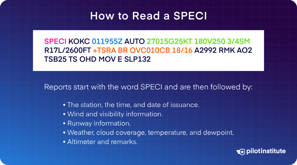
SPECI KOKC 011955Z AUTO 27015G25KT 180V250 3/4SM R17L/2600FT +TSRA BR OVC010CB 18/16 A2992 RMK AO2 TSB25 TS OHD MOV E SLP132
- SPECI: The type of report (in this case, a special weather report).
- KOKC: The station identifier (Will Rogers World Airport).
- 011955Z: The date and time of issuance (first day of the month at 19:55 UTC).
- AUTO: Indicates an automated report without human intervention.
- 27015G25KT 180V250: Wind information (wind from the west at 15 knots, gusting to 25 knots, with a variable wind direction from 180° to 250°).
- 3/4SM: Visibility of ¾ statute miles.
- R17L/2600FT: Runway visual range (RVR) for runway 17L is 2,600 feet.
- +TSRA BR: Heavy thunderstorms with rain and mist.
- OVC010CB: Overcast layer of cumulonimbus clouds at 1,000 feet AGL.
- 18/16: Temperature of 18°C and dew point of 16°C.
- A2992: Altimeter setting of 29.92 inHg.
- RMK AO2 TSB25 TS OHD MOV E SLP132: Remarks indicating the automated station, thunderstorm beginning at 25 minutes past the hour, thunderstorm overhead moving east, and sea-level pressure of 1013.2 hPa.
Let’s take a closer look at some of these SPECI components.
In this SPECI, the RVR for runway 17L is 2,600 feet.
- +TSRA BR
Next up, you’ll see the present weather section. This includes precipitation, obscurations, and other weather phenomena. The SPECI also mentions how intense or close these are to the airport.
The table below shows a guide to the codes in this section. Can you figure out what our SPECI says?
| Intensity or Proximity | Descriptor | Precipitation | Obscuration | Other |
| – Light | MI – Shallow | DZ – Drizzle | BR – Mist | PO – Dust/Sand Whirls |
| Moderate | PR – Partial | RA – Rain | FG – Fog | SQ – Squalls |
| + Heavy | BC – Patches | SN – Snow | FU – Smoke | FC – Funnel Cloud, Tornado, or Waterspout |
| VC – In the Vicinity | DR – Low Drifting | SG – Snow Grains | VA – Volcanic Ash | SS – Sandstorm |
| BL – Blowing | IC – Ice Crystals (Diamond Dust) | DU – Widespread Dust | DS – Dust Storm | |
| SH – Showers | PL – Ice Pellets | SA – Sand | ||
| TS – Thunderstorms | GR – Hail | HZ – Haze | ||
| FZ – Freezing | GS – Snow Pellets | PY – Spray | ||
| UP – Unknown Precipitation |
In our SPECI, it says that you should expect heavy thunderstorms and mist.
- OVC010CB
Sky condition describes the appearance of the sky. It includes cloud cover in oktas, vertical visibility, and clear skies.
Each layer is coded using the appropriate contraction in the table below:
| Reportable Contraction | Meaning | Summation Amount of Layer |
| VV | Vertical Visibility | 8/8 |
| SKC or CLR | Clear | 0 |
| FEW² | Few | 1/8 – 2/8 |
| SCT | Scattered | 3/8 – 4/8 |
| BKN | Broken | 5/8 – 7/8 |
| OVC | Overcast | 8/8 |
The contractions “FEW,” “SCT,” “BKN,” and “OVC” will be followed by the layer’s height. They are given in hundreds of feet above the surface using three digits.
In this example, you should watch out for an overcast layer (ceiling) of cumulonimbus clouds 1,000 ft AGL.
- 18/16
After this, you’ll see temperature and dewpoint information. They’re coded as two digits rounded to the nearest whole degree Celsius.
Sub-zero temperatures are prefixed with an M. For instance, a temperature of 4ºC with a dewpoint of -2ºC will be coded as 04/M02.
Our SPECI says that the temperature is 18ºC, and the dewpoint is 16ºC.
- A2992
The altimeter group always starts with an “A,” followed by the four-digit group representing the pressure in inches of mercury with the decimal point removed.
In our example, an altimeter setting of 29.92 inHg would be coded as A2992.
- RMK AO2 TSB25 TS OHD MOV E SLP132
Finally, the remarks section in a SPECI gives you extra weather details not found in the main report, like storm specifics, runway conditions, and pressure changes.
In our example, “AO2” means it’s an automated station that can tell the difference between rain and snow. “TSB25” shows a thunderstorm began at 19:25 UTC, and “TS OHD MOV E” means a thunderstorm is overhead, moving east.
Lastly, sea level pressure is shown as “SLP” followed by numbers. For “SLP132,” add “10” in front and place a decimal before the last digit to get 1013.2 hPA.
That’s it! You now know everything there is to know about SPECI.
Conclusion
Basically, SPECIs bridge the gap between hourly METARs. They give you real-time updates when the weather changes on you unexpectedly.
Next time you see “SPECI” on a report, know it’s there to give you that heads-up on what’s changed—fast. METARs give a steady beat of info, and SPECIs give you the precision updates you need when it matters most.
Fly safe!


