VOR (Very High Frequency Omnidirectional Range) stations were once the most common radio navigational aid (NAVAID) in the United States. The advent of GPS has made them obsolete to some degree. Yet, many aircraft still heavily rely on these NAVAIDs.
Since 2016, the FAA has been decommissioning VORs as GPS becomes the primary form of navigation. The issue is that aircraft need a navigational backup in the event of a widespread GPS outage. To address this, the FAA introduced the Minimum Operational Network (MON), a scaled-down system of VORs designed to ensure redundancy.
As a result of the MON, the FAA changed the Standard Service Volumes (SSVs) in December 2020. This article will examine the older service volumes and explore the changes to better understand the new volumes.
Key Takeaways
- The Minimum Operation Network (MON) has forced the FAA to change Standard Service Volumes (SSVs).
- The FAA added two new expanded SSVs for Low and High VORs.
- VOR service volumes are now identifiable on an IFR low enroute chart.
What is a Service Volume?
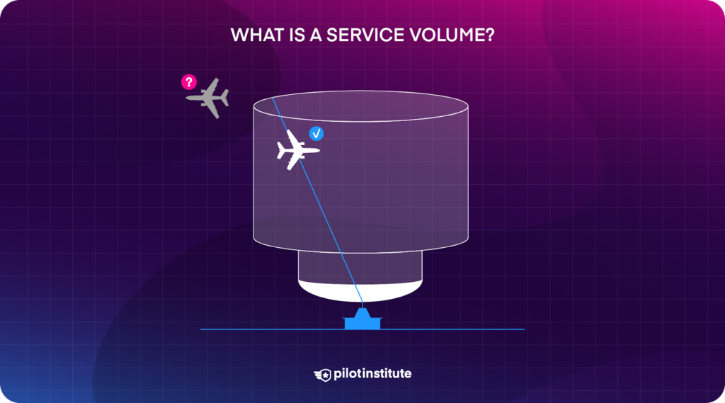
A service volume is a three-dimensional area where aircraft can reliably pick up the NAVAID’s signal, free from interference.
When we use a VOR within its service volume, the FAA ensures navigational accuracy, accounting for standard errors.
Original Service Volumes
Previously, there were three main types of VOR service volumes: Terminal, Low, and High.
All VOR service volumes begin at 1,000 ft AGL, as signals below this altitude are unreliable and can cause confusion and incorrect indications. Therefore, all service volumes begin 1,000 ft above the station elevation.
Terminal
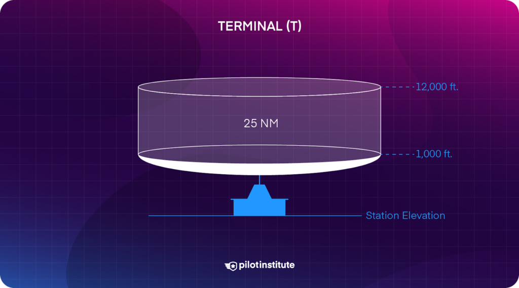
Terminal VORs have the smallest service volume. They provide reliable navigation services for areas up to 25 NM from the transmitter. As mentioned, the service volume begins at 1,000 ft and continues to a maximum altitude of 12,000 ft above the station.
The small service volume means that these types of VORs are usually co-located with airports and are typically used for approaches.
Low
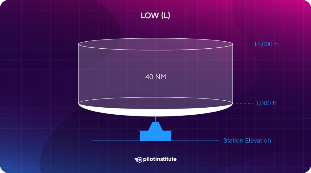
Low VORs provide reliable navigation services for areas of 40 NM from the transmitter. The service area begins at 1,000 ft and continues to a maximum altitude of 18,000 ft above the station.
High
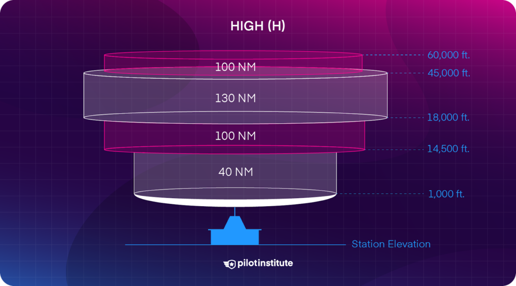
High VORs provide the most range of all the legacy VORs. This service volume changes with altitude, making it look like an upside-down wedding cake.
The first layer resembles a Low VOR, with 40 NM coverage from 1,000 ft to 14,500 ft. From 14,500 to 18,000 ft, the range extends to 100 NM. The largest layer begins at 18,000 ft and continues to 45,000 ft, providing reliable navigation to 130 NM. The final layer is from 45,000 ft to 60,000 ft and shrinks in distance, providing navigation to 100 NM.
The New Standard Service Volumes
Thanks to improvements in transmitter technology, VORs are now more powerful and capable than previous generations. The FAA has added two new types: VOR Low and VOR High.
Like the old VORs, the new VORs’ service volumes begin at 1,000 ft. Radio wave propagation at low altitudes can be disturbed and is unreliable.
VOR Low
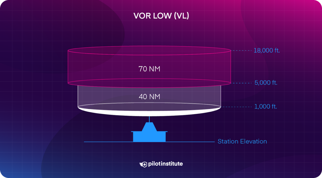
Unlike legacy Low VORs, these new VORs (VL) have two layers. The first begins at 1,000 ft and ends at 5,000 ft. It allows navigation to 40 NM.
The second and final layer ends at 18,000 ft and provides reliable navigation up to 70 NM. This service expansion offers pilots a considerable increase in navigation range at higher altitudes over the legacy VORs.
VOR High
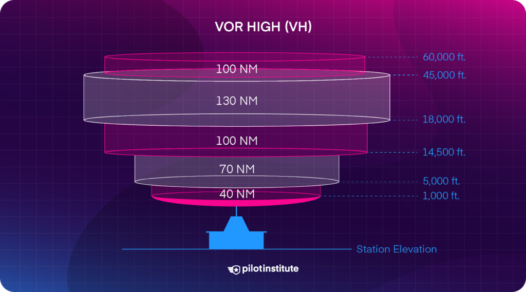
The new High VOR service volume contains five layers, compared to the four layers of the old service volume. The extra layer directly results from the Low VOR service volume change.
As always, the first layer begins at 1,000 ft and ends at 5,000 ft, providing navigation up to 40 NM from the transmitter. The second layer ends at 14,500 ft and provides navigation up to 70 NM.
The three remaining layers remain the same as the legacy service volume. 14,500 ft to 18,000 ft provides navigation to 100 NM, and 18,000 ft to 45,000 ft provides navigation to 130 NM. Finally, the last layer goes from 45,000 ft to 60,000 ft and offers navigation up to 100 NM from the transmitter.
How to Identify the VOR Service Volume
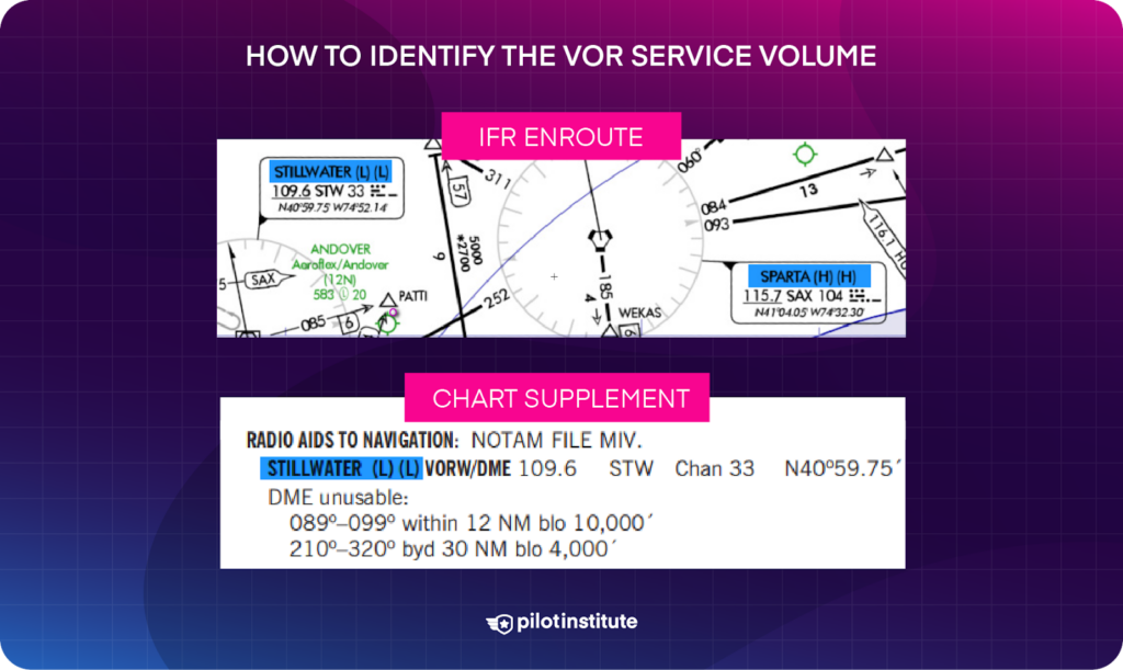
Currently, there are two ways to determine a VOR’s service volume:
- View the VOR info box on an IFR low or high enroute chart.
- Check the Chart Supplement for NAVAID info.
In 2022, the FAA (and Jeppesen) began listing VOR service volumes directly on the IFR enroute charts. You’ll see letters in parentheses indicating the SSV in the info box.
You can also find VOR service volumes in the Chart Supplement under an airport’s Radio Aids to Navigation section.
The SSV is identified by (T), (L), and (H) for legacy volumes and (VL) and (VH) for new service volumes.
There will be two letters if the NAVAID has more than one component (e.g., a VORTAC or VOR/DME). Here’s how to decode it:
- The first letter is the VOR’s SSV.
- The second letter is the other component’s SSV (e.g., TACAN, DME).
Conclusion
The FAA plans to maintain a working network of VORs in case of GPS outages. Newer VORs are more powerful. As a result, the FAA has simplified and expanded the types of service volumes.
Though the FAA is decommissioning VORs nationwide, they are still a heavily used resource for navigation and maneuvers such as holding. To learn how to fly the perfect hold, read this.

